An extended run of W/SW swell continues

South Australian Forecast by Craig Brokensha (issued Wednesday 25th January)
Sign up to Swellnet’s newsletter and receive the South Australian Forecaster Notes and latest news sent directly to your inbox. Upon signup you'll also enter the draw to win a surf trip to P-Pass for you and a mate (this is the final week). It doesn’t get much easier so click HERE to sign up now.
Best Days: Mid Coast each day working the tides, Saturday afternoon, Sunday, Monday, South Coast Friday morning onwards
Recap
Poor conditions down South with a fresh to strong onshore wind and poor windswell, while the Mid Coast was a bumpy 1-1.5ft, growing in size and strength through the afternoon and cleaning up late.
Today tiny 1-1.5ft waves were continuing on the Mid, while the South Coast was cleaner and fun at magnets, with 2ft sets off Middleton.
This week and weekend (Jan 26 - 29)
From today through the rest of the week we'll see small levels of W/SW swell across the coast, generated by small persistent mid-latitude frontal activity passing under the country.
The Mid Coast should persist around 1-1.5ft on the favourable parts of the tide, while Middleton is only due to be around 2ft tomorrow and Friday.
Winds will swing back onshore for the South Coast tomorrow with a S/SE breeze, while the Mid will be cleanest during the morning and late in the day.
Friday will become cleaner again down South with a morning NE'ly ahead of afternoon sea breezes.
A slight kick in power is due on Saturday, produced by stronger W'ly gales developing in our western swell window, south-west of WA today.
This should see slightly stronger sets down South to 2-3ft off Middleton and 1-1.5ft on the Mid (possibly kicking to 2ft with the afternoon tide).
An even better W/SW swell is due to fill in on Sunday though, produced by a slightly weaker but persistent mid-latitude low forming on the tail of the fetch generating Saturday's swell and projecting towards the Bight, before dipping a touch south and towards Tasmania.
A building trend is expected through Sunday, reaching 2ft into the afternoon on the Mid Coast, while the South Coast should increase to 3ft+ across Middleton.
 Winds on Saturday will be good for both coasts with a morning offshore and afternoon sea breezes, with favourable E/NE winds Sunday morning.
Next week onwards (Jan 30 onwards)
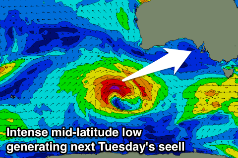
Into Monday the W/SW swell should ease back from 1-2ft on the Mid Coast and 3ft on the sets at Middleton with great conditions under a N/NE tending NW offshore. A late change will be linked to an intense mid-latitude low moving in from the west, producing yet another W/SW groundswell for Tuesday.
This swell looks to be a little stronger and larger, peaking Tuesday afternoon, but more on this Friday.