Best Saturday morning down South

South Australian Forecast (issued Wednesday 10th February)
Best Days: Keen surfers Friday morning down South and late on the Mid, Saturday morning South Coast, Mid Coast Monday morning
Recap
Tiny start to yesterday ahead of a new pulse of SW groundswell which over-performed across the Mid with 1-2ft sets into the evening, still present at dawn this morning but more in the 1-1.5ft range. A classic case of lower-period swell sneaking in through Investigator Strait better than longer-period energy.
The South Coast was workable but small yesterday morning before sea breezes kicked in, with better 2-3ft sets this morning across Middleton and more size out at Waits with light S'ly winds.
This week and weekend (Feb 11 - 14)
South Coast: A drop in swell is expected tomorrow morning with moderate to fresh S/SE winds, creating poor conditions.
Friday should see better and lighter E/SE winds through the morning with small 2ft sets at Middleton and 3ft+ waves at Waits and Parsons ahead of a new SW groundswell through the afternoon.
This SW groundswell is looking a touch better with the weak polar frontal progression generating it holding its strength under the Bight as it moved in from the south-east Indian Ocean.
Middleton should kick to a good 3ft into the afternoon with 4ft+ sets at Waits and Parsons with moderate S/SW sea breezes.
Saturday is the day to surf as the swell eases from 2-3ft and 4ft respectively under early NW winds, swinging W/NW through the morning ahead of a fresh SW change around midday.
Sunday will then be a write-off with fresh S/SW winds, but a new building S/SW groundswell.
The source of this S/SW groundswell will be a 'bombing low' but the structure and south-east track of the system is not as favourable as forecast on Monday.
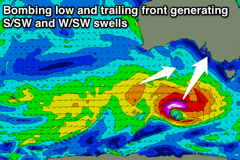 Still we should see a short-lived fetch of severe-gale to storm-force SW winds generated through our southern swell window, producing a moderate sized S/SW groundswell kicking to 3-4ft at Middleton and 5ft at Waits into the afternoon easing back from a similar size Monday morning, but with persistent onshore S/SW winds.
Mid Coast: Yesterday afternoon's and today's SW swell should ease back to a tiny 0.5-1ft tomorrow, with Friday afternoon's kick likely to see 1-1.5ft sets developing, easing back from 1ft+ Saturday morning.
While Sunday's S/SW swell isn't expected to really impact the Mid, a better aligned front behind the 'bombing low' should produce a fun W/SW swell for later in the day to 1ft, peaking Monday morning to 1-1.5ft.
Longer term, weak but persistent frontal systems will move under the Bight, producing plenty of fun SW swell for next week but with persistent onshore winds down South, cleaner on the Mid. More on this Friday.