Tuesday morning the best of the week

South Australian Forecast (issued Wednesday 30th December)
Best Days: Tuesday morning South Coast, Saturday and Sunday mornings South Coast
Recap
Solid levels of S/SE windswell providing waves at novelty spots for keen surfers, while the Mid Coast was a tiny 0.5ft.
Today the S/SE windswell was back down to the 2-3ft range with lighter E'ly winds early favouring protected spots for a surf, while the Mid remained tiny and clean.
This week (Jan 5 - 8)
South Coast: Tomorrow morning is the best chance for a clean wave across the South Coast this coming week.
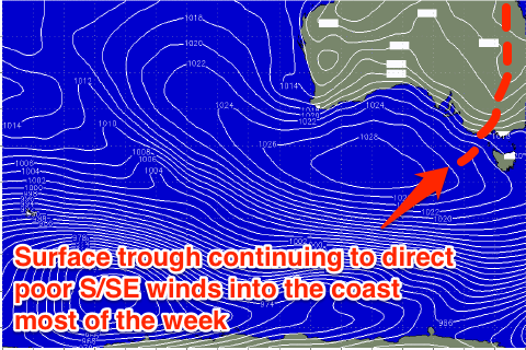
A surface trough that's currently sitting just to our east will weaken slightly tomorrow and slip a touch further west resulting in winds tending light E/NE tomorrow morning down South ahead of S/SE sea breezes.
 This should create fun peaky waves, but the swell will be weak from the S/SE and to 2-3ft across most exposed locations.
From Wednesday the trough will drift back to the east resulting in fresh to strong S/SE winds, kicking up some new S/SE windswell, holding Thursday with SE tending S/SE winds. Friday should see the trough starting to weaken with weaker but still fresh SE winds and easing levels of S/SE windswell.
Mid Coast: Tiny clean waves are expected for most of the week, with an inconsistent long-range SW groundswell for Thursday likely to provide the odd 1ft set (more so on the incoming tide), easing from a similar size Friday morning.
This weekend onwards (Jan 9 onwards)
South Coast: Conditions will finally improve into the weekend with the arrival of a fun new S/SW groundswell.
This swell will be generated by a healthy polar front producing a fetch of W/NW gales through our southern swell window.
Middleton should see fun 2-3ft sets, with 3-4ft waves at Waits and Parsons Saturday, easing back through Sunday morning.
A morning E/NE wind will create peaky conditions before sea breezes kick in, while Sunday looks straighter with a N'ly offshore ahead of a shallow change.
The Mid Coast isn't expected to see any size from this swell with tiny 0.5ft sets max.