Fun South Coast tomorrow and through the weekend

South Australian Forecast (issued Monday 31st August)
Best Days: Tuesday South Coast, early Wednesday keen surfers South Coast, Saturday South Coast, Sunday morning South Coast
Recap
Average conditions Saturday with a fresh E'ly wind and sloppy mix of swells down South, while Sunday was the pick with a better offshore N/NE breeze with peaky fun waves across exposed breaks.
Today conditions were a bit straighter with a light offshore wind again down South with 2-3ft sets across Middleton with better and punchier waves out at Waits and Parsons. A light sea breeze has just started to develop but conditions are still clean. The Mid Coast is also clean but tiny and around 0.5-1ft.
This week and weekend (Sep 1 – 6)
Make the most of tomorrow as we'll see easing levels of swell under favourable and fresh N/NE tending N/NW winds (becoming funky and variable late afternoon).
Middleton is expected to ease from a small 2ft+ with 4ft sets at Waits, smaller into the afternoon and into Wednesday with strong but easing N/NE tending N/NW winds ahead of a possible late onshore change.
The rest of the week will be poor with a surface trough pushing across us Wednesday evening bringing strong S'ly winds and a building windswell Thursday, easing Friday with S/SW winds. The Mid will see tiny levels of building swell Thursday to 1-1.5ft, fading Friday.
The weekend will be better for a surf, with a mix of long-range and inconsistent SW groundswell and short-range SW swell. The short-range swell will be generated by a small front swinging in under WA and towards Tassie through the end of the week, while the long-range swell is being produced by a strong but distant polar front currently in the Heard Island region.
Middleton should see inconsistent 2-3ft sets with 4-5ft waves at Waits and Parsons and 1ft waves on the Mid.
 Winds should be good and light offshore from the N/NE, tending variable into the afternoon, and then N'ly tending light S'ly winds Sunday as the swell eases.
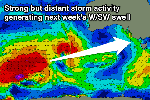
Longer term, some better long-range W/SW groundswell is due into early next week, generated by a larger, broader and more vigorous polar frontal progression south-west of WA during the end of this week.
Winds are looking a little dicey for the South Coast and better on the Mid at this early stage, but we'll review this again Wednesday.