Mid Coast Friday, South Coast from then on for great waves

South Australian Forecast (issued Wednesday 16th July)
Best Days: Thursday in protected locations down South, Friday on the Mid, Saturday onwards down South
Recap
The South Coast offered great waves all day yesterday with an inconsistent but good 2-3ft of swell at Middleton with bigger waves out at Waits under N'ly winds. The Mid Coast was tiny and choppy with a freshening N'ly breeze.
Today a new mix of swells are building across both coasts with clean 3ft waves this morning down South at Middleton and tiny choppy waves on the Mid again. Winds are now strengthening from the NW and with this we should see an increase in windswell along with a stronger W/SW groundswell across the Mid, while the South Coast should also build in size as winds strengthen from the W/NW.
This week and weekend (Jul 17 -20)
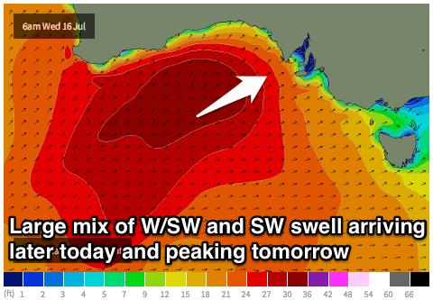 This afternoon a mix of long-range but strong W/SW groundswell and localised windswell are due to build across the Mid Coast to 2-3ft+. The Cape du Couedic buoy is on a rapid rise, with a broad and vigorous frontal system pushing through the Bight now starting to move across Adelaide.
Tomorrow morning should reveal 3-4ft waves across the Mid with a mix of windswell and groundswell under fresh to strong W'ly winds. A drop in size is due into the afternoon and further Friday from 2-3ft, but winds should improve considerably, swinging S'ly Friday morning creating great waves across selected locations.
The South Coast will see a mix of W/SW groundswell and closer-range SW swell from the tail of the front as it pushes through tomorrow. Middleton should see 5ft waves through tomorrow with larger 6ft+ sets out at Waits but strong W'ly tending SW winds will only favour protected locations, and initially through the morning, they won't offer any major size with the westerly nature of the swell.
Friday will remain large but conditions will be poor with a fresh but easing S/SW wind. Late in the day may be worth a look if you're in the area as winds really back off.
The weekend is looking great for waves across the South Coast, and while the Mid Coast will also be clean there won't be any major swell with a fading 1ft+ wave from Saturday onwards.
Around Victor, offshore N'ly tending variable winds on Saturday will create clean conditions with an easing swell from 3-5ft along the Middleton stretch with 4-5ft+ sets at Waits and Parsons.
Sunday will provide better waves at Waits and Parsons for experienced surfers as the swell drops back to 3-4ft+ or so under N/NE winds. A late kick in new S/SW groundswell may be seen, but this is discussed further below.
Next week onwards (Jul 21 onwards)
The frontal activity will finally settle down through next week as a strong blocking high moves in slowly from the west. This won't mean there won't be swell, with the westerly stormy track remaining active all the way from Heard Island to under the country, with a couple of intense polar fronts expected to generate some fun pulses of S/SW groundswell.
The first is due later Sunday to 3-4ft across Middleton and 4-5ft at Waits before easing from a similar size Monday morning. Conditions will be excellent with a fresh but easing N/NE breeze.
Another slightly smaller SW groundswell should arrive through Tuesday and build into the afternoon as winds remain OK and fresh to strong from the N/NW.
Into the end of the week smaller but clean surf is due and exposed beaches will offer the best bang for your buck if you've got the ability.