Fun week around Victor Harbor

South Australian Forecast (issued Monday 30th June)
Best Days: Tuesday morning through Friday morning down South, Sunday down South
Recap
The Mid offered stormy 3-4ft waves Saturday morning but the swell dropped through the afternoon as winds backed off.
The South Coast was cleaner and in the medium sized range with a strong W'ly wind, but a large kick in S/SW swell was seen through the afternoon, offering good waves in protected locations.
The swell eased overnight but Sunday morning was still solid but poor with onshore winds. A temporary swing to W'ly winds was seen through the morning, but before lunch winds took a bad turn to the S/SW again.
Today is much better down South with an offshore NW wind and good swell in the 4ft range, while the Mid Coast is a poor 1-1.5ft.
This week (Jun 30 – Jul 4)
Good waves are due across the South Coast most of the week, biggest through tomorrow and Wednesday morning before fading into Thursday.
A new S/SW groundswell is due to fill in tomorrow but the models seem to be over-forecasting the size a little with only a 3ft wave expected at Middleton with 4ft sets at Waits. This swell should then ease from 2-3ft and 3-4ft respectively Wednesday.
Winds should tend variable and light from the NW through tomorrow morning with a weak W/SW'ly due into the afternoon. Wednesday looks much better with offshore N/NW winds persisting all day.
Thursday will become tricky with a stronger N/NW breeze and small easing swell, get in early for the best of it
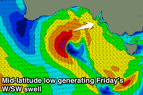 Into the end of the week a mid-latitude low moving in from WA should kick up a good W/SW groundswell for the Mid Coast Friday to 2-3ft. Winds will be poor and fresh to strong from the W/SW tending SW though as the low pushes across us and towards Tassie.
As the low does push across us though, an additional SW tending S/SW swell will be generated for the South Coast although with winds swinging SW it will be average. The morning should be workable though with a strong W/NW'ly and fun W/SW swell to 2-3ft at Middleton and 3-4ft at Waits.
This weekend onwards (Jul 5 onwards)
Friday's W/SW swell will fade across the Mid Coast Saturday as winds remain average and from the SW.
The South Coast should continue to offer plenty of size early with the S/SW swell, but conditions will also be poor with the onshore breeze. Sunday is looking a lot better as winds swing back to the NW, but you'll have to get in early before the swell drops away.
Into the start of next week there's nothing major on the cards, but the second half of the week is looking a lot more interesting. A strong amplification of the Long Wave Trough is forecast to move in from the west and with this we should see a series of vigorous polar fronts pushing up towards us, generating at least one large pulse of groundswell later in the week.
Check back here on Wednesday for a running update on these developments though.
Comments
Good ol' winter is back!!