Active, windy period of surf ahead

South Australian Surf Forecast by Ben Matson (issued Friday 23rd May)
Best Days: Sat/Sun: Good surf down south with good winds. Sun: keep an eye out for a sneaky long range swell in the a'noon. Mon onwards: waves on the Mid all next week but generally onshore and bumpy.
Recap: Great waves down south both days with offshore winds and an easing swell ahead of an (apparent) late pulse in new S/SW swell this afternoon. Small residual surf on the Mid but generally clean.
This week (May 22-23)
*sorry - super short today as I’m low on time. Craig is back next week*
This weekend (May 24-25)
Great weekend of waves down south. We’ve got a new S/SW swell starting to push into the region and it’ll provide clean 3ft waves across the Middleton stretch on Saturday, with smaller surf on Sunday. Offshore winds will prevail both days (with a brief overnight W’ly change on Saturday unlikely to do any great damage) so there’ll be good options everywhere. Expect long breaks between the bigger sets.
Unfortunately, this swell direction won’t favour the Mid Coast (due to the swell shadowing of Kangaroo Island) so tiny residual swell is expected on Saturday. However, as per Wednesday’s notes, Sunday will see the arrival of a very long period SW groundswell that was generated mid-week by an intense storm many thousands of kilometres away. The bulk of this energy is expected to push through on Monday, and the enormous travel distance will keep a lid on size prospects in the gulf.
That being said, it’s possible that we may see some infrequent waves building to (perhaps) between 1ft and maybe 2ft late on Sunday afternoon if we’re super lucky. And with twenty minute breaks between sets too. Winds will be light so conditions should be clean.
I’m still not especially confident for this swell to deliver anything worthwhile, so I’d recommend a Victor mission on Sunday - but keep an eye on the CdC buoy in the morning, and the South Port surfcam around lunchtime - and make the dash back in the afternoon if it starts to show signs of building.
Next week (May 26-30)
We’ve got a very complex forecast period ahead for the region with a strong cut off low expected to migrate slowly through the Bight over the weekend. The models have now firmed up what will probably happen at the surface - most of this system will probably be initially located over land, or inside the swell shadow of the lower SW of WA (i.e. the Margs coast) as the low approaches the mainland.
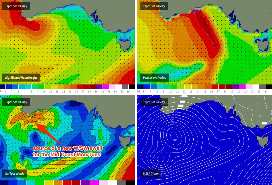
A smaller, slightly weaker fetch will push through the northern Bight (see image below) but right now I can’t see much more than a couple of feet of groundswell for the Mid, coming in two pulses - one on Monday (on top of the pre-existing long range groundswell) and another on Tuesday. Local windswell could add another couple of feet on top of this depending on the strength of the winds.
Additionally, it’s going to become quite windy so conditions won’t be great. There’s a chance for a brief period of lighter N’ly winds at some point on Monday (early? late? I’m not sure yet) but Tuesday will invariably see strengthening NW tending SW winds as the associated front crosses the region. So, a mid-range stormy for the Mid Coast (maybe even some small waves on the metro beaches?) and not much down south due to the swell direction.
Just as a side note, Monday should see small clean waves down south with the strengthening northerly wind. But mainly restricted to the swell magnets.
The computer models have now wiped off the chance of a big S/SW swell for the Victor coast Wed/Thurs, and instead have a mobile solution consisting of back-to-back fronts through the Bight.
This points to an extended period of strong swell on the Mid (relatively speaking) through the second half of the week, but with average/variable conditions under a mainly onshore airstream. Similar conditions are expected down south but with less swell (due to the swell direction). So in short, there’ll be waves all week but don’t expect any great quality.
Longer term (May 31 onwards)
More frontal activity expected into next weekend and the following week. All fairly standard for this time of year which is a promising sign. More from Craig on Monday!
Comments
The CdC buoy picked up the leading edge of the anticipated super long range groundswell in the early hours of this morning (18 sec, see below). Will be interesting to see if we pick up any swell in the gulf from it.
Also of interest - today is a good example of how the Noarlunga AWS is not necessarily a good representation of local winds at the coast. It's recorded a light N'ly flow under 6kts since 10pm last night - dropping below 3kts since 3am - yet there is visible scarring on the surface (via the South Port surfcam), which suggests slightly stronger winds (say, 10kts+). This is a common occurrence, due to the AWS being located inland.
Coupla small lines on the Mid this arvo. Long wait for sets but looks 1-1.5ft.