Good surf from Wednesday onwards, with tiny waves to kick off the weekend

South Australian Forecast (issued Monday 5th May)
Best Days: Wednesday, Thursday, early Friday, Sunday on both Mid and South Coasts, Monday
Recap
Saturday was poor across the state with plenty of swell but strong onshore winds from the S/SW. The Mid Coast offered the best of it with a lighter S'ly wind and peaky 1-2ft of swell.
Sunday was much better down South with a moderate and easing S/SW groundswell under favourable W/NW winds during them morning, while the Mid Coast offered tiny 1-1.5ft waves with variable winds.
Today conditions were good again down South with an early NW'ly and moderate SW swell, but an onshore change has since moved through, creating poor conditions. The Mid was still in the 1-1.5ft range but average with a N'ly breeze.
This week (May 5 - 9)
The new S/SW swell due tomorrow afternoon across the South Coast has been downgraded a touch due to the deepening low pressure system to our south-southwest forming a little later in our swell window and pushing more into Tassie than Vicco.
Still, this tight low is generating a fetch of gale to severe-gale SW winds on the periphery of our swell window and should generate a medium to large sized S'ly groundswell for tomorrow afternoon to 4-5ft across most locations along the South Coast, with 6ft sets at swell magnets. The Mid Coast won't see any size at all, with tiny 0.5-1ft surf expected.
Winds will improve on this afternoon's onshore down South but remain average and from the East, but Wednesday however looks great with the swell easing from 3-4ft+ under NE winds that should persist into the early afternoon.
From Wednesday afternoon onwards, the swell will drop steadily away with nothing of note due until the weekend. Winds will remain favourable for exposed locations though with a fresh N/NE'ly breeze all day Thursday and stronger N'ly Friday, creating tricky conditions with the minimal amount of swell.
This weekend onwards (May 10 onwards)
Saturday will be close to flat down South and with fresh NW tending SW winds, it'll be worth giving a miss around Victor.
A new acute W'ly swell is due on the Mid though, generated by a vigorous front dipping south-east from WA and then pushing through the Bight on Friday. This should kick up an afternoon increase to 2ft before easing from a similar size on Sunday morning.
The South Coast on Sunday should see some W/SW swell off this front filling in but only to 2-3ft at Middleton and 3-4ft out at Waits. Winds should be favourable for the Mid and light offshore, while the South Coast will be lumpy under a light variable wind before weak SE sea breezes kick in.
Into next week we should see the arrival of a long-range but strong SW groundswell across the state and under offshore winds!
The source of this swell will be a series of strong polar fronts firing up one after the other in our far swell window in the Heard Island region.
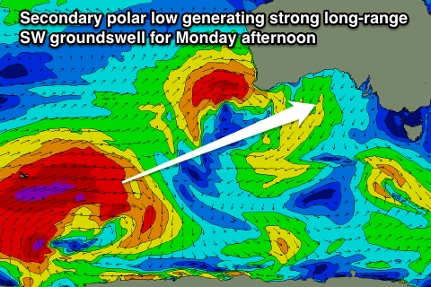 An initial broad fetch of severe-gales will setup an active sea state for a secondary polar low to piggyback over the top of, generating an additional fetch of severe-gales and large W/SW groundswell (pictured right).
Due to the large distance between the source of the swell and our coasts, there'll be a lot of swell decay and loss in consistency, but when the sets do arrive, they'll be strong.
Size wise, the swell should kick strongly Monday afternoon, reaching an inconsistent 3-5ft at Middleton with 5-6ft sets at Waits mixed in with the possible bigger bomb. The Mid Coast should see inconsistent 2ft+ waves into the afternoon and under N/NE winds, conditions look unreal.
Check back here on Wednesday for confirmation on the timing and local winds around this swell, but at the moment it doesn't look like there'll be much change.