Indonesia/Maldives forecast Dec 12

Indian Ocean Basin analysis by Craig Brokensha (issued Thursday 12th December)
This week through next (Dec 11 - 20)
Our large, inconsistent groundswell should have built through yesterday and will be on the ease today, with this trend continuing into tomorrow and the weekend.
A small mid-period SW swell should boost wave heights slightly into late Sunday but more so Monday, though we’ve got our larger swells to follow into Wednesday and Thursday.
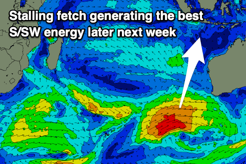
The source of the larger energy is a strong frontal progression that’s currently south-east of South Africa, with it originating to the south of that country earlier this week.
An initial strong low has generated a long-range SW groundswell for Wednesday/Thursday next week, though only moderate in size, and the evolution of the following progression as it moves east over the coming days will produce some better, closer-range energy.
Various fetches of gale to at times severe-gale W/SW winds will race across the southern Indian Ocean, with the speed not being ideal for swell generation (as the storm races ahead of the swell it's producing).
As the progression nears Western Australia though it’s due to stall, with a great fetch of strong to gale-force winds being projected through Indonesia’s southern swell window.
What we can expect from all this activity is a mix of jumbled swell trains, arriving later Tuesday and building through Wednesday ahead of a peak into the evening/Thursday morning.
The models are incorrectly combining all these varying swells and over-forecasting the size but we should still at least see 6-8ft surf Wednesday afternoon and Thursday morning.
The current monsoonal surge should start to back off into tomorrow and the weekend, bringing more variable, local offshore winds (ahead of afternoon sea breezes), but we’re likely to see winds slowly strengthen through next week again as the next surge arises.
Over in the Mentawais, strong NW winds are slowly easing across the region but we’ll then see winds tipping W/NW on the weekend and then W-W/SW into Sunday with weaker SW winds to the north.
Gusty NW winds look to again develop across southern regions next week with weaker W/NW-NW breezes to the north.
----------------------------------------------
Maldives: We’ve got a low point in swell energy across the region, but some small S’ly groundswell is due to fill in tomorrow ahead of better pulses from Sunday, peaking Monday next week.
The best swell for Monday was generated by the initial stages of the frontal progression now mobilising east, with the strong low generating a moderate sized pulse that will then be reinforced by a secondary good pulse into Tuesday as the progression moved further east.
The SE trade-swell signal will be weak and inconsistent but we should see a renewal of energy from the weekend of the 21/22 if all goes to plan. More on this next week.
Eastern Indonesia:
Easing surf over the coming days.
Small, mid-period SW swell for later Sunday and Monday to 3-4ft across exposed breaks.
Moderate to large mix of SW swells building next Wednesday to 6-8ft across exposed breaks later, easing out of the S/SW from a similar size Thursday.
Variable tending locally offshore winds tomorrow and on the weekend, slowly increasing from the W/NW-W/SW through next week.
Uluwatu 16-day Forecast Graph/WAMs
Western Indonesia/Mentawais/South Sumatra:
Easing groundswell into the weekend.
Small-moderate sized, mid-period SW swell building Sunday, reaching 4ft across exposed breaks, easing Monday.
Moderate to large mix of SW and S/SW swells building Tuesday, peaking next Wednesday to 6ft to occasionally 8ft across exposed breaks, easing slowly Thursday.
Easing NW winds into the weekend, tending more W/NW with funkier winds to the north.
Increasing NW winds again next week to the south, weaker W/NW-NW to the north.
Mentawai 16-day Forecast Graph/WAMs
Maldives:
Small, inconsistent S’ly groundswell tomorrow to 3-4ft on the southern atolls (smaller Male).
Inconsistent S’ly groundswell Sunday but more so Monday to 4-5ft across the southern atolls (smaller Male), with a secondary, reinforcing pulse Tuesday, easing slowly through the week.
Moderate W/SW winds tomorrow (fresher to the south), similar but tending more W’ly on Saturday, weaker and W/NW-NW on Sunday.
Slowly strengthening W-W/SW winds mid-late next week.
Comments
Latest notes are live.
Cheers Craig , had a window yesterday from 2pm - 4 pm where the wind dropped and glassy 3-4 ft on NL . Today back to pissing down rain which looks set in for rest of the year . Can only imagine what the east coast water quality is now like aagggghhhh .
Heading to Nusa Dua for a family trip at on of the big resorts on the 3rd of Jan for 10 days. Planning on hitting Main Peak (Geger right?) and Chickens most days (with gratitude to the kids club).
Has anyone surfed out there recently, I haven't surfed it in 15 years. It's typically offshore this time of year? Appreciate any advice.
You should be sure to get waves PL, unless devil south wind kicks in, but that is usually mid morning.
Late arvo sessions can be magic that time of year.
Road goes right around to Pandawa now so other options abound.
Cheers Andy.
I had a week there in November PL and loved it. Following advice from Andy Mac, Udo and co, was out there by 5.30-6amish for the dawny and got good, glassy uncrowded sessions all week. When I say uncrowded I mean literally 2-3 others. No serious size but nothing under 3-4ft occasionally a bit bigger. Lots of fun.
I screenshotted their tips for reference. Main points to remember are paddle out under temple, watch out for rogue sets on the head, Euro kooks and grumpy Seppos.
Cheers Joshy, good info, that'll be me then each morning. 3 - 4 foot is perfect. Were there any boats heading out and would you recommend that? Or just paddle.
Boats don't usually start until after 7 i think.
Easier just to paddle if hitting early, walk up to temple, don't try paddling out front in front of warungs.
Enjoy!
Yeah as Andy says it’s a pretty easy paddle, I didn’t bother with boats.
Done, thanks gents.
The advice, so accurate :))
Ha, indeed!
Indo is looking a damn sight more interesting than east coast Australia
True dat!!!
A reprieve from the rain today and managed a solo 1&1/2 hour surf , shoulder high sets . Rain looks to be back tomorrow for next 10 days .