Indonesia/Maldives forecast January 18

Indian Ocean Basin analysis by Craig Brokensha (issued Thursday 18th January)
This week through next (Jan 18 - 26)
Small surf the last couple of days, but we should see a tricky S’ly swell arriving tomorrow across the region, performing best from Bali to West Java and South Sumatra.
This was generated immediately to the south-west of of Western Australia earlier this week and performed well across the Margaret River region but very short-lived with a quick up/down cycle.
We can expect similar tomorrow, with the south magnets pulsing through the day before the swell disappears Saturday.
To replace this S’ly swell, some inconsistent SW groundswell is due, with it arriving into the late afternoon, peaking Sunday afternoon. It’s source to the south-east of South Africa will result in a loss in consistency and size.
Strengthening monsoonal W/NW-W/SW winds will favour selected more protected spots.
Unfortunately the rest of the period looks flukey, with tricky swell pulses that are hard to discern with no standout systems due at all.
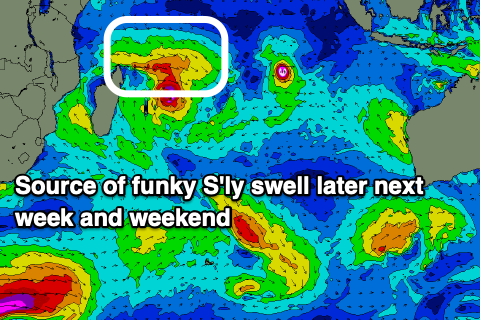
An interesting low pressure gyre setting up west of Madagascar and then deepening into a tropical cyclone looks to produce some moderate sized W’ly swell for the Mentawais and West Java from later next week and into the weekend.
Otherwise, localised westerly windswell looks to develop across eastern Indonesia thanks to strong W’ly monsoonal winds.
The Maldives have seen winds back off from the E/NE but it looks to only be temporary with the monsoon due to strengthen again over the coming period, kicking up out of the E/NE from the weekend and really muscling up next week.
This will bring building levels of E/NE swell with strong E/NE winds that looks to reach 3ft to occasionally 4ft next week.
Ahead of this though some good, inconsistent S’ly groundswell is on track for tomorrow, building later in the day before easing Saturday.
The strengthening winds off Madagascar (mentioned above for the Ments) look a little to W/NW in angle to generate any major swell for the Maldives but we’ll continue to watch these developments.
Otherwise, small levels of background swell from the SE look to come in around 3ft or so from next week, arriving from various sources, one being Tropical Cyclone Anggrek to the south-west of Sumatra.
Eastern Indonesia:
Small-moderate sized, mid-period S’ly swell pulsing to 3-4ft during the day tomorrow across select locations, easing rapidly Saturday.
Inconsistent SW groundswell building later Saturday, peaking Sunday afternoon to 4ft on the magnets.
Strengthening W/NW-W/SW winds over the coming days, peaking later next week.
Small background levels of S/SW swell in the mix next week with some poor, localised W’ly windswell.
Uluwatu 16-day Forecast Graph/WAMs
Western Indonesia/Mentawais/South Sumatra:
Small mid-period S/SE swell Saturday to 2-3ft on the magnets.
Inconsistent SW groundswell building Saturday, peaking Sunday to an inconsistent 4ft on the magnets.
Moderate sized, mid-period W’ly swell building mid-late next week, peaking through the weekend to 4ft across exposed breaks.
Easing winds tomorrow, becoming variable with a slight NW tendency across southern locations over the coming days, more variable next week.
Mentawai 16-day Forecast Graph/WAMs
Maldives:
Inconsistent, moderate sized S’ly groundswell building tomorrow, reaching 4ft+ on the southern atolls late, easing Saturday from a similar size.
Building E/NE windswell next week, reaching 3ft to occasionally 4ft but with strong E/NE-NE winds, lighter at times to the south.
Background SE swell next week to 2-3ft.
Comments
Latest notes are live.
Thanks Craig , I will let you know what tomorrow brings . Lembongan doesn’t really like direct south swell but around the corner at mahana point is a very good indication of what the swells doing . Storm clouds brewing today and it’s tried to rain several times but just not happening. The water table must be getting low. They are currently building a desalination plant on Lembongan , funded by klungkung government. They built one on ceningan but it only works occasionally . 2.5 million rp for locals to get hooked up then 47,000 rp for cubic meter , which is apparently double what they charge in Bali . If ever there was a place to harness water turbines, then this place is perfect with a current that runs nonstop ( and quickly ) between penida and ceningan. Indo government needs to investigate this as an alternative power source all over indo . I can’t believe a german company never won the contract for serangan dump as they apparently have technology that generates power from rubbish . Some of the images of rivers in Indonesia that get posted on instagram break ya heart .
Today’s pulse bypassed lembongan , knee to waist high at best . Around the corner at swell magnet was chest high and the occasional head high set . Sets of 5 waves but really close together. Wind was strong sw this morning and raining for about 1 hour . Lunchtime wind dropped off to nothing and this arvo had glassy conditions , would have been nice with some swell .
Thanks Supa. So a tiny hint of something. Flukey and better to the west.
That Western Pacific swell..