Poor run of surf continues

Hawaii North Shore forecast by Craig Brokensha (issued Thursday 29th December)
Best Days: No great days
This week and next (Dec 30– Jan 6)
Hawaii: A reinforcing NW groundswell seen yesterday afternoon and this morning is now easing across the North Shore with small leftover surf due into tomorrow morning.
Our new mid-period N/NE swell due later tomorrow, peaking Friday is still on track, but the follow up N/NE groundswell looks to be a touch smaller.
Currently a trough west of the US is squeezing a strong high to the north of us, aiming a fetch of strong N/NE winds through our northern swell window, but also reaching down towards us.
 With this, onshore NE winds will create poor conditions with 6ft or so of N/NE swell Friday morning, easing through the afternoon and further Sunday.
The small low forming further away from us should produce a small reinforcing N/NE groundswell for later Sunday and Monday morning, coming in at 3-4ft or so.
NE winds will persist through the weekend though only easing and tending back to the E/NE Tuesday when the swell will be small.
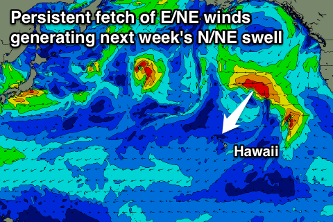
Some further N/NE groundswell is due mid-late next week as the low persists in some form to our north-east, squeezing the high as it stalls south of Alaska.
A stationary fetch of E/NE gales will be generated just within our swell window, producing small to moderate levels of N/NE groundswell from Wednesday afternoon through until the weekend, coming in around 3ft or so.
Some mid-period NW swell energy should also be in the water, produced by distant fetches in our far swell window, also coming in 3-4ft+ Thursday, easing off slowly Friday.
Variable winds should create clean conditions through the middle of next week before a N'ly breeze develops Friday. More on this next update.
North Shore Forecast Graph
North Shore WAMs
Micronesia: Small amounts of E/NE trade-swell will continue over the coming days, easing back from early next week and becoming weaker.
Protected breaks won't see any size at all, but a small new N/NW groundswell should fill in Sunday and peak Monday morning across the region.
There's been no change to the size expected across the coast, with exposed breaks due to build to 3ft+ later Sunday and peak Monday morning to 3-4ft, easing into Tuesday and the rest of the week.
Light winds this morning will unfortunately pick up from the E/NE this afternoon and persist most of the period.
Palikir Pass Forecast Graph
Palikir Pass WAMs
Papua New Guinea: Our downward trend in NE trade-swell will continue into the weekend leaving small 2ft+ waves across the coast through most of the period.
The N/NW swell should arrive across our coast Monday and come in around a similar 2ft+ and variable winds will create clean conditions.
Longer term there's still nothing significant on the cards, but check back Tuesday for any change to the outlook.