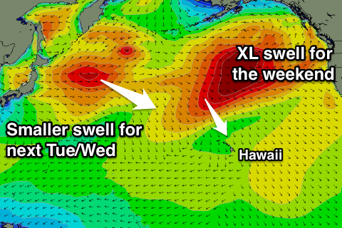
XL swell for the weekend, smaller but large swell for the Pipe Masters

Hawaii North Shore forecast by Craig Brokensha (issued Thursday 3rd December)
Best Days: Every day over the coming period (experienced surfers only during the large swlel events)
This week and next (Dec 4 - 11)
A large new N/NW groundswell has peaked today across Hawaii with solid triple overhead + sets on the North Shore and great waves for the Finals day of the Maui Target Pro.
 We should see this swell ease a touch later this afternoon, down further tomorrow from the 8ft+ range on the sets, smaller into Friday and Saturday morning.
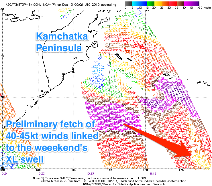
Our XL swell due over the weekend is still on track, with a powerful and broad low currently sitting south-east of the Kamchatka Peninsula already generating a fetch of severe-gale W/NW winds in Hawaii's north-western swell window.
This low will strengthen through today resulting in winds reaching the storm-force range at its core before projecting ideally south-east towards us.
This will generate a very large long-period NW veering N/NW groundswell for the weekend that should kick late Saturday to the 15ft range on dark from a small 3-4ft or so during the morning.
A peak is expected overnight, easing from the XL 15-18ft range Sunday morning with larger sets at deepwater offshore reefs.
Strong E/NE trades are due to ease slowly tomorrow and further into Friday, being only moderate to sometimes fresh through the weekend creating favourable conditions.
Into next week the swell should ease out of the N/NW from the 8ft range, further down into Tuesday morning (the first day of the waiting period for the Pipe Masters) as winds continue to ease.
The swell won't stay small for long though, with a flurry of strong storm activity due to develop off Japan and make its way east closer towards Hawaii through the weekend and early next week.
An inconsistent and moderate sized W/NW groundswell generated off the Japanese coast will be overridden by a larger and better NW groundswell from a fast moving but intense low projecting a fetch of severe-gale to storm-force W/NW closer to Hawaii.
This swell will arrive just ahead of the smaller W/NW groundswell late in the day Tuesday, building to the 10ft range ahead of a peak Wednesday morning to the 10-12ft range. The models look as if they are over-forecasting the peak of this swell as it combines the W/NW and NW swells together.
Strong E/NE trades are due to kick back in mid-next week but we'll have a closer look at this in Tuesday's update.
Comments
And the Pe'ahi Challenge has been given the green light for this weekend.
Looking forward to seeing some Gary-sized waves getting ripped this weekend