Peaky windswell, cleanest as it eases

Eastern Tasmania Surf Forecast by Craig Brokensha (issued Monday 4th January)
Best Days: Southern corners for the desperate tomorrow, Wednesday morning, Friday morning south swell magnets
Features of the Forecast (tl;dr)
- E/NE tending E/SE swell for tomorrow and Wed, cleanest Wed AM
- S'ly groundswell for Thu PM and Fri AM, cleanest Fri AM
Recap
Tiny surf Saturday with a small lift in swell yesterday with light onshore winds, bigger today from the NE as a surface trough deepened to our north.
This week and weekend (Jan 5 - 10)
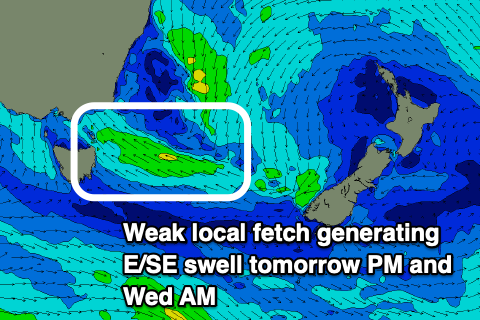
The surface trough sitting just north-east of us has weakened but is still aiming a fetch of strong E/NE winds into us and this should keep 3ft sets hitting open beaches tomorrow through with fresh S/SE tending SE winds.
During tomorrow we’ll see the trough drift south-east, aiming a fetch of strong E/SE winds through our swell window before swinging SE and then SW out of our swell window Wednesday morning. This will see the surf easing from 2-3ft out of the E/SE Wednesday but with SW winds, shifting SE into the afternoon as a trough pushes up the coast.
 This trough isn’t expected to generate much in the way of swell and the low that was forecast to form in the Tasman Sea now looks to form over near New Zealand. This isn’t favourable for swell generation at all.
It should be worth noting that there’ll be a S’ly groundswell in the water Thursday afternoon and Friday morning, generated by a strong polar low that’s currently south-southwest of Western Australia.
The low is just within our swell window and we should see infrequent 2-3ft sets across south swell magnets later in the day but with those SE winds, easing from 2ft to maybe 3ft Friday morning with better NW tending NE winds.
Longer term we may see some small NE windswell next week, but more on this in Wednesday’s notes.