Small surfable N/NE windswell this week

Eastern Tasmania Surf Forecast by Craig Brokensha (issued Monday 12th November)
Best Days: Tuesday northern ends of beaches, Wednesday morning north-east magnets
Recap
A contamination of tiny to flat surf over the weekend, similar today.
Today’s Forecaster Notes are brought to you by Rip Curl
This week and weekend (Nov 13 - 18)
Our N/NE windswell event due over the coming days is still on track, with a surface trough currently moving in from the west, squeezing a strong high in the Tasman Sea.
This trough will stall slightly resulting in a strong N/NE fetch remaining positioned in our swell window from this evening through all of tomorrow, moving slightly away from us tomorrow evening but more so through Wednesday evening.
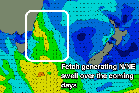 We should see the most consistency tomorrow with building sets to 2-3ft across north-east facing beaches during the afternoon, easing back slowly from s peak in size to 3ft on Wednesday morning.
A N/NW tending NW breeze is due most of tomorrow, favouring northern ends of beaches. Wednesday morning looks good with a light W/SW offshore, giving into a SE tending E change, so north facing beaches should clean up before becoming bumpy into the afternoon.
A stronger S'ly change Wednesday evening will bring a small weak S'ly windswell to 2ft or so on Thursday along with poor S'ly winds.
We'll be back to tiny surf on Friday and the weekend, with a possible small N/NE windswell into early next week, but we'll have another look at this on Wednesday.