Action heating up from this weekend, climaxing with a large swell Tuesday

Java, Bali, Lombok, Sumbawa forecast by Craig Brokensha (issued Tue 6th May)
Best Days: Thursday onwards, but only for experienced surfers from Monday afternoon into the rest of the week
This week (May 6 - 9)
After a fun weekend of waves, we're on a downwards trend in size, and we'll see wave heights bottom out tomorrow across Bali to 2-3ft at only the most exposed locations.
A bump in size is due on Thursday as a long-range S/SW groundswell fills in, generated last week by a series of broad but not especially strong frontal activity in the Southern Ocean.
This should provide inconsistent 3-5ft sets at exposed locations tomorrow afternoon before easing slightly from a similar size on Friday morning. Light to moderate E/SE trades through tomorrow are expected to pick up through Thursday and then become fresh through Friday and remain in the moderate to fresh range for the rest of the period.
This weekend onwards (May 10 onwards)
From this weekend onwards, we've got an active period ahead with a moderate to large SW groundswell Saturday afternoon and Sunday morning expected to be backed up by a much larger and more powerful S/SW groundswell Tuesday.
The first increase due over the weekend is being generated by a mid-latitude front pushing fairly north into the Indian Ocean, aiming a fetch of strong to gale-force S/SW winds through our swell window.
The swell from this system should arrive Saturday from a SW direction and peak later in the day to 5-6ft+ across exposed spots before easing from a similar if not slightly smaller size on Sunday.
Of greater importance is the development of a vigorous polar frontal progression around the Heard Island region from today.
An initial broad and vigorous system should generate a fetch of severe-gale W/SW winds tonight and early tomorrow, setting in motion a large active sea state for a secondary stronger and more favourably aligned polar front to piggyback up and over.
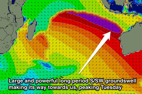 This secondary system should generate an additional fetch of severe-gale SW winds towards WA, producing a large, long-period and powerful S/SW groundswell (pictured right).
The swell should arrive strongly later Monday and peak Tuesday in the 10-12ft range across exposed spots, with the odd bigger bomb possible at swell magnets.
There should be a touch less size east of Bali due to swell decay, but the sets will still be very large and powerful.
After Tuesday's peak the swell should drop through Wednesday, but another large S/SW groundswell is due Thursday afternoon, but not to the size on Tuesday's. We'll review this again on Thursday so check back then for an update.