A slower period but there should be a couple of small waves to surf through this week for the savvy.
Primary tabs
/reports/forecaster-notes/eastern-tasmania/2022/04/18/small-east-followed-small-south
Craig
Monday, 18 April 2022
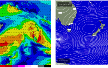
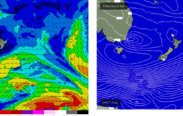
/reports/forecaster-notes/eastern-tasmania/2022/04/15/fun-sly-swell-focus
Craig
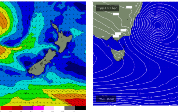
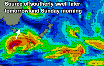
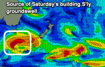
Friday, 15 April 2022
Light winds ahead of sea breezes tomorrow with a building S'ly groundswell, cleaner and easing Sunday.
/reports/forecaster-notes/eastern-tasmania/2022/04/13/smaller-surf-new-south-swell-the-weekend
Craig
Wednesday, 13 April 2022
Smaller levels of swell this period but with fun small waves for the right equipment.
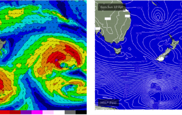
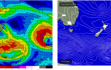
/reports/forecaster-notes/eastern-tasmania/2022/04/11/lots-surfing-options-period
Craig
Monday, 11 April 2022
A good mix of swells from the north-east and south with favourable winds.

/reports/forecaster-notes/eastern-tasmania/2022/04/08/ne-swell-over-the-weekend-another-mixed-bag
freeride76
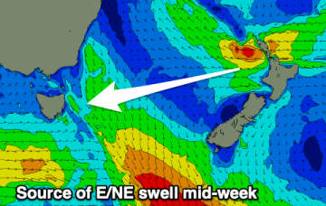
Friday, 8 April 2022
Longer period surf from the E/NE, generated by the long-lived E’ly fetch in the South Pacific, makes landfall on Mon.
/reports/forecaster-notes/eastern-tasmania/2022/04/06/surf-the-s-and-ne-weekend-light-winds
freeride76
Wednesday, 6 April 2022
A strong low which passed through the Tasman is also sending a quantum of longer period S to S/SE swell which will see surf heights build from the S to SSE over the next 24-36 hrs.
/reports/forecaster-notes/eastern-tasmania/2022/04/04/mixed-bag-small-s-and-ne-swells-week-better
freeride76
Monday, 4 April 2022
A large cradling fetch of E to SE winds south of the cyclone is better aimed at sub-tropical areas but should still produce some swell for the East Coast of Tasmania early next week.
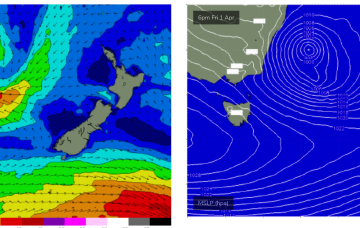
/reports/forecaster-notes/eastern-tasmania/2022/04/01/plenty-surf-and-wind-weekend-conditions
freeride76
Friday, 1 April 2022
A deep Tasman low is expected to reach peak strength through this a’noon, with a general southwards movement favouring ETas, as it places the fetch wrapping into the SE quadrant within the swell window.
/reports/forecaster-notes/eastern-tasmania/2022/03/30/plenty-swell-and-sly-wind-low-winds-nsw-coast
freeride76
Wednesday, 30 March 2022
Severe gale force winds are proximate to the NSW Coast and are well placed to generate plenty of S swell for Tasmania before a better angled ESE to E swell hits on the weekend.
/reports/forecaster-notes/eastern-tasmania/2022/03/28/action-aplenty-cold-front-and-tasman-low
freeride76
Monday, 28 March 2022
The weekend looks juicy. Whilst the Tasman low is not ideally aimed at Tasmania, E to SE winds feeding into the low are expected to generate a strong E’ly swell for the NE Coast.