Lots of surfing options this period

Eastern Tasmanian Surf Forecast by Craig Brokensha (issued Monday April 11th)
Best Days: Tomorrow, Wednesday, Thursday, Friday, Sunday south magnets
Features of the Forecast (tl;dr)
- Inconsistent E/NE-NE trade-swell tomorrow, easing into the PM, a touch smaller again Wed
- Moderate sized S groundswell for Wed, possibly undersized at dawn, easing Thu
- W/SW tending N/NE winds tomorrow, W tending E/NE Wed and NW Thu
- Inconsistent E/NE groundswell building later Thu, easing Fri with fresh N/NW tending W/NW winds
- Building S swell Sat with SE tending NE winds, easing Sun with NW winds
Recap
A localised NE windswell to kick off Saturday, with some better trade-swell filling in yesterday as winds improved, though best today with an even stronger pulse of energy emanating from a ex Tropical Cyclone Fili.
This week and weekend (Apr 12 - 17)
The coming week is packed full of swell with energy from both the E/NE-NE and S’th due across the state.
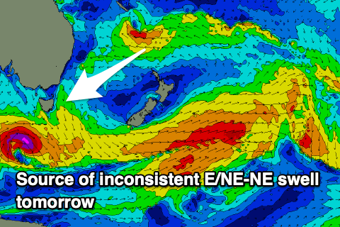 Firstly to the tropical activity and ex Tropical Cyclone Fili is still sitting north of New Zealand, squeezing a strong high in the Tasman Sea, aiming a great fetch of strong E/NE winds through our swell window. This fetch has been established since late last week and Fili has added extra bursts of stronger winds, generating inconsistent but longer period sets which should be seen tomorrow and Wednesday though the most size is likely tomorrow.
Open beaches should see infrequent 3-4ft sets tomorrow, easing slowly through the day but holding 3ft on the sets Wednesday though coming in more around 2-3ft.
One final pulse of inconsistent E/NE groundswell is due later Thursday and Friday just before Fili falls behind the swell shadow of New Zealand, and this should keep infrequent 3ft sets hitting the swell magnets.
Also in the mix on Wednesday will be a building S’ly groundswell, generated by a strong polar low that’s currently south-west of the state. A fetch of severe-gale to storm-force W/SW winds are being generated and we should see 4ft sets developing across the south magnets through the day, easing back from 2-3ft on Thursday.
 Coming back to the local winds and a W/SW offshore is due tomorrow ahead of N/NE sea breezes, then W tending E/NE on Wednesday. Thursday should see all day NW winds with a freshening N/NW tending W/NW breeze due Friday ahead of an evening change.
This change will be linked to a trough sliding up the coast leaving S/SE tending NE winds across the state.
Some small mid-period S’ly swell is due off the polar front linked to the trough with it due to build to 2-3ft Saturday afternoon, easing Sunday from a similar size with N/NW breezes.
Longer term there’s a few small sources on the cards for next week, but more on this Wednesday.