Great surf today and over the weekend

Victorian Forecast by Craig Brokensha (issued Friday July 18th)
Best Days: Every day this period, with the beaches to the east Tuesday morning and Wednesday afternoon/Thursday
Features of the Forecast (tl;dr)
- Large W/SW groundswell today with persistent NW winds, easing into tomorrow AM
- Mod-large, reinforcing W/SW groundswell for tomorrow PM, easing slowly Sun with some mid-period swell in the mix
- Strong N-N/NW tending N/NW winds tomorrow AM, NW into the PM
- Fresh NW winds Sun AM, easing and tending N/NE later to the east
- Moderate sized SW groundswell Mon AM, easing, smaller Tue
- Strengthening N-N/NE winds Mon
- Strong N-N/NE tending N/NW winds Tue
- Moderate sized W/SW groundswell Wed with N/NW tending N/NE winds
- Easing swell Thu with gusty N/NE tending NE winds
Recap
Our first pulse of groundswell filled in and peaked Wednesday night across the regions, with yesterday morning offering great but slowish 4-5ft sets across the Surf Coast under offshore winds. A change moved through during the day creating deteriorating conditions and this morning we’ve got our secondary pulse of larger W/SW groundswell in the water.
The Surf Coast is the pick again with clean 5-6ft sets on the magnets, with a slight drop due through the day as winds hold from the NW.

Good sized sets and conditions today
This weekend and next week (Jul 19 - 25)
Two swell pulses down, one to go.
The secondary pulse of large W/SW groundswell from a strong progression of storms under the country should peak through today, with it due to ease into tomorrow morning under early, strong N-N/NW winds.
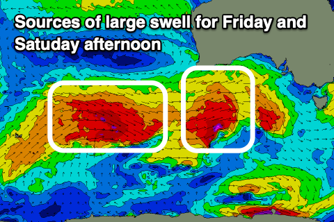
Through the afternoon though, our third and final pulse of W/SW groundswell is due, with it coming in a touch under the size seen today. This was generated by a final fetch of severe-gale W/NW winds moving in on the active sea state generated by storm linked to today’s swell.
This should see the Surf Coast building from 3-5ft in the morning to a stronger 4-5ft through the late afternoon, then easing Sunday from the 3-5ft range. To the east, the morning looks to be 6ft+, building back to 6-8ft with easing sets again from 6ft+ due on Sunday morning.
It’s worth noting that there’ll also be some mid-period W/SW swell in the mix Sunday from a weak front moving through tomorrow evening.
Coming back to the local winds and those early, strong N-N/NW winds tomorrow are due to shift more NW into the afternoon with Sunday seeing fresh morning NW winds, easing into the afternoon and even tending N/NE-NE to the east later.
Into Monday, we’re set to see the easing trend slowed one final time by a small, strengthening low drifting south-east through our swell window on Sunday. A fetch of W/NW gales looks to maintain 3-4ft sets early on the Surf Coast Monday, easing through the day with 5-6ft waves to the east, smaller Tuesday.
Local winds for this swell look best for the beaches with a strengthening N/NE breeze through Monday, N/NE-N tending N/NW through Tuesday.
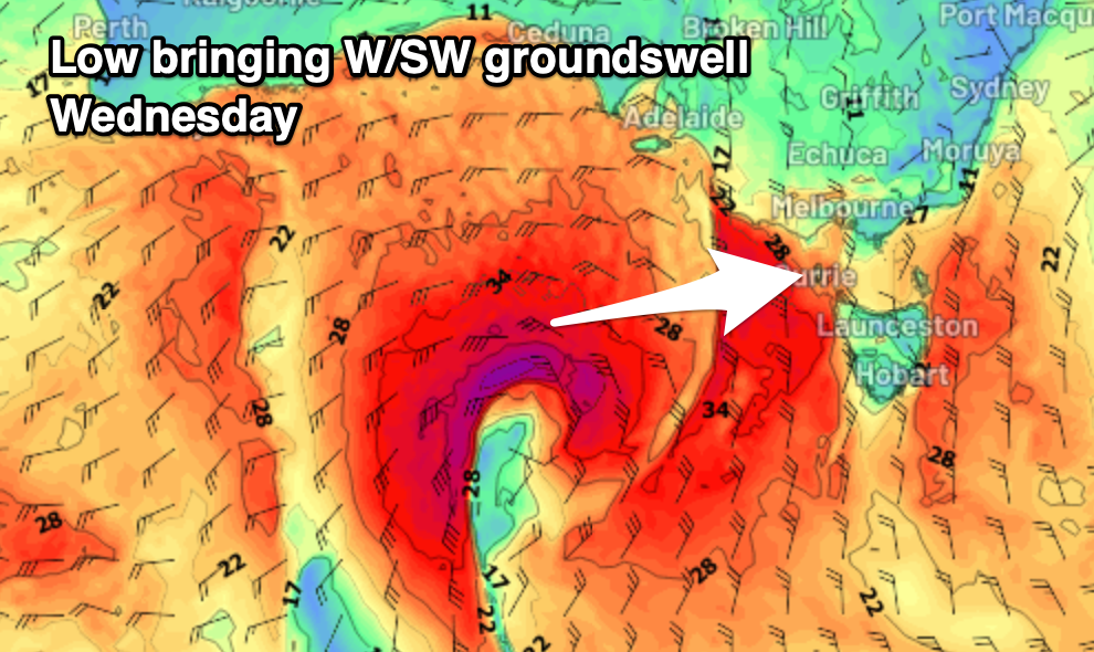
Now, as flagged in Wednesday’s notes, a deepening mid-latitude low in the Bight is expected to drop south-east into our swell window on Tuesday and with this we’re expected to see a great fetch of W/SW gales projected in our western swell window. This looks to generate a moderate sized increase in W/SW groundswell Wednesday, likely to 3ft on the Surf Coast and 4-6ft to the east.
Winds could be favourable for both coasts and N/NW in the morning before shifting N/NE into the afternoon but we’ll confirm this Monday.
As the swell eases Thursday, it looks like N/NE tending NE winds will favour the exposed beaches with the next run of swell likely to kick in from next weekend. Have a great weekend!
Comments
All hail the Lord and Master, King O's!!
Wonder if we might see the King himself gracing some vicco reefs over the next 72hrs?
Very hard now with the new bub and off to Japan in August!
Bring the bub down …. I’m sure Swivel will babysit for you whilst you go surfing!! haha
Enjoy Japan!
Ha, true!
So flat on the GC, its mesmerizing watching the Winki cam you lucky penguins
Praise our lord Craigos! What a tremendous run of waves
Thanks Craig for the swell and wind conditions recently appreciate it mate
Think this is day 14 of 15. Best run of clean conditions and swell for so long
Today looks really good.
Yes, today was one of the better days this year for sure on the Surf Coast. Lots of people surfing at many breaks and overflowing carparks which you would expect with that forecast. More like a weekend crowd than a weekday. Hope everyone got a few.
Weather and conditions 10/10
5/10 day down the great ocean road for swell and crowds. Underwhelming slow 3-4 ft
WP the same, very average (but let’s be honest, it’s always underwhelming lol)
Yeah not the size or direction for both regions.
That’s surprising dbut.
Was really pumping closer to Torquay.
Couple of very fun surfs.
Thanks for this run of swell and perfect winds Craig! Your hard work doesn’t go unnoticed
Started in Torquay
Drove all the way to past lesser known spots
Ended up back in Torquay
Btw was cooking
Not so further south was average
One for the local lads.
More energy and consistent waves before dark.
Great long range call for the Friday, King!!
Much funner conditions across a variety of places this arvo than Friday
Craig can you please do the QLD forecast, this tiny spell has gone on long enough.
Beautiful left at Woolamai this morning
