Indonesia/Maldives forecast Jul 17

Indian Ocean Basin analysis by Craig Brokensha (issued Thursday 17th July)
This week through next (July 18 - 25)
We’ve got small surf across the region this morning but come this afternoon, our first pulse of moderate to large sized S/SW groundswell should be starting to build, with a peak expected tomorrow morning.
This will however be quickly overridden by a larger, long-period S/SW groundswell arriving through the day, reaching the most size through the late afternoon/evening.
There’s been no change to the expected timing and size of this swell with it coming in around forecast in Western Australia.
We’ve seen multiple fetches of severe-gale to at times storm-force winds acting on top of each other, generating an overactive train of swell activity.
As touched on in Tuesday’s notes, the models are incorrectly combining the groundswell energy for the morning with the new building energy, over-forecasting the size. We should still see exposed breaks reaching 10ft later tomorrow, easing from a similar size Saturday morning, with the pure magnets likely to see the odd bigger cleanup at the peak of the swell.
The easing trend still looks to be softened through Sunday thanks to the arrival of a large reinforcing S/SW groundswell, generated by a final frontal system projecting towards the south-west of Western Australia today.
This is due into the afternoon, with the swell then due to ease into Monday and Tuesday next week.
Now, as also mentioned in the last notes, a strong mid-latitude forecast off the Western Australian coast has come in as a weaker trough as forecast by the European model ECWMF.
With this we’re now not expecting much in the way of swell with weak surf due mid-late week.
Longer term we may see a healthy Southern Ocean frontal progression generating some fun S/SW groundswell from next weekend onwards. More on this next week.
Local winds still look a touch dicey tomorrow into the afternoon when the new swell arrives with morning offshores shifting S/SE, similar Saturday with SE trades kicking back in slightly from Sunday before reverting back to the S/SE Monday/Tuesday.
From Wednesday onwards we’ll hopefully see E/SE-SE winds kicking in but we’ll confirm this next week.
Over in the Mentawais the current variable winds are expected to slowly freshen across southern locations through the weekend, with SW breezes to the far north, with S/SE-SE winds due all of next week across most locations. Freshest to the south and weaker and more variable to the north.
----------------------------------------------
Maldives:
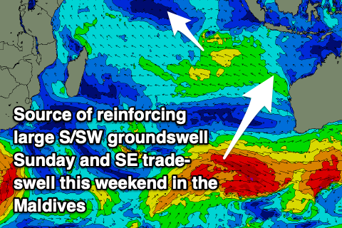
A large reinforcing pulse of S/SE trade-swell should be in the water today, with this expected to start easing tomorrow as fresh pulses of SE trade-swell move in over the weekend.
This will be generated by the remnants of the super-charged SE trade-fetch being squeezed by a small tropical depression yesterday and today, further tomorrow before weakening and moving west on the weekend.

A moderate + sized pulse of SE swell is due Saturday/Sunday, then easing slowly into early next week.
We then look towards the next trade-swell episode and it looks to arrive out of the S/SE through the middle of next week, generated by a burgeoning fetch of SE trades forming south-east of us Tuesday, spreading north through the week.
We should also see a S/SE groundswell signal in the mix from a healthy looking low forming north-east of the Heard Island region Friday/Saturday.
Size wise we’ve got moderate + levels of energy due, with the possibility for some larger sets, but we’ll see how things play out.
Local winds still look strong from the W/NW-W over the coming days, a little weaker across southern locations, with winds slowly easing across northern and central locations next week from the W-W/SW as S/SE winds kick in across southern regions.
Eastern Indonesia:
Moderate to large S/SW groundswell building later today, peaking Friday tomorrow morning to 6ft+.
Larger, long-period S/SW groundswell building through tomorrow, reaching 10ft across exposed breaks, easing slowly 10ft Saturday morning. Chance for the rare bigger cleanup at the peak of the swell.
Large, reinforcing S/SW groundswell Sunday afternoon to 8ft+, easing Monday.
Weak S/SE winds tomorrow and Saturday, with fresher SE trades Sunday, weak S/SE into early next week. Fresher SE-E/SE winds from mid-late next week.
Light, local offshore winds are due each morning.
Uluwatu 16-day Forecast Graph/WAMs
Western Indonesia/Mentawais/South Sumatra:
Moderate + sized S/SW groundswell building this afternoon to 4-6ft across exposed breaks.
Larger, inconsistent S’ly groundswell building tomorrow, reaching 8ft+ into the afternoon, easing from a similar size Saturday.
Reinforcing, inconsistent S’ly groundswell Sunday afternoon to 6ft to possibly 8ft, easing slowly Monday from 6ft+.
Variable winds are expected to slowly freshen across southern locations through the weekend, with SW breezes to the far north. SE-SE winds due all of next week across most locations. Freshest to the south and weaker and more variable to the north.
Mentawai 16-day Forecast Graph/WAMs
Maldives:
Easing S/SE trade-swell tomorrow.
Reinforcing, moderate + sized SE trade-swell for the weekend to 4-5ft+ across the southern atolls, smaller to the north.
Easing SE swell early next week.
Moderate + sized S/SE trade-swell and S/SE groundwell building again mid-next week, reaching 4-5ft+ across the southern atolls Wednesday, smaller to the north. Swell possibly easing a touch Thursday before re-strengthening Friday.
Strong W/NW-W winds over the coming days, a little weaker across southern locations, with winds slowly easing across northern and central locations next week from the W-W/SW as S/SE winds kick in across southern regions.
Comments
Latest notes are live.
Thanks Craig.
So would you say the models are over-calling the swell from the 26/07 - 30/07 for Java?
What do you reckon the O’s?
Oh yeah, looks like they are. Swell for that weekend looks 6-8ft.
thanks Craigo’s
EC is looking better actually, more 8ft, will keep an eye on it.
yeah baby
Reports of the building swell this morning with slow 8ft sets. More to come..
Ulu Cams showing Plenty keep us informed I.B. - Go Easy on the Gudangs Stuart.
A mate was at OC this morning then Impossibles for the late. Looks like it built during the day as per the forey.
Good Size on the Bukit this Morning
Bang on today with your Mentawai forecast, great way to ease into it , 4-5 ft well overhead .
Bang on today with your Mentawai forecast, great way to ease into it , 4-5 ft well overhead .
Thanks Supa, also heard the large reinforcing S/SW groundswell came in strong as well later Sun/yesterday AM.