Into the weekend and we will see conditions improve as a high moves to the north of the island and fronts to the south bring about westerly ridging.
Primary tabs
/reports/forecaster-notes/eastern-tasmania/2024/04/17/offshore-winds-and-tiny-s-swells-ahead
freeride76
Wednesday, 17 April 2024

/reports/forecaster-notes/eastern-tasmania/2024/04/12/s-swells-and-small-ene-swells-continue-over-the
freeride76
Friday, 12 April 2024
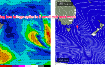
More S groundswell expected next week, with a renewal in S swell Tues from a deep low passing under Tas later Sun into Mon.

/reports/forecaster-notes/eastern-tasmania/2024/04/10/overlapping-s-swell-pulses-carry-through-and
freeride76
Wednesday, 10 April 2024
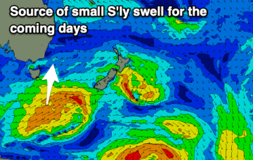
Under this sharp trough in the jet stream, as Craig pointed out, strong polar fronts are being steered NE below the Tasman, with long period S swells wrapping into the East Coast of Tasmania.

/reports/forecaster-notes/eastern-tasmania/2024/04/08/plenty-long-period-s-swell-making-landfall-week
freeride76
Monday, 8 April 2024
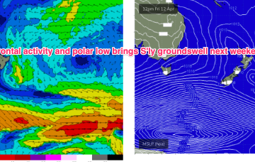
Strong frontal activity to the south tied to slow moving and complex polar lows is better aimed at NZ and South Pacific targets but plenty of refraction and sideband southerly energy is expected to make landfall in addition to the Tasman low swell this week and into the weekend.

/reports/forecaster-notes/eastern-tasmania/2024/04/05/plenty-swell-filling-in-over-the-weekend-0
freeride76
Friday, 5 April 2024
Over the weekend we’ll see the interior low approach and then exit the Gippsland Coast. Initially that will draw down the NE-E/NE fetch and we’ll see building swells from that direction .
/reports/forecaster-notes/eastern-tasmania/2024/04/01/busy-week-ne-and-s-swells-and-some-juice
freeride76
Monday, 1 April 2024
By Sat morning we should see a surface low hugging the coast and tracking southwards down the NSW. A broad infeed across SE and NE quarters of the low will see a range of swells trains incoming over the weekend, with plenty of size expected.

/reports/forecaster-notes/eastern-tasmania/2024/03/29/tiny-over-easter-much-more-the-radar-next-week
freeride76
Friday, 29 March 2024
It’s quite a bland synoptic outlook with a large area of high pressure moving into the Tasman and becoming slow moving as it weakens. That is forcing fronts well to the south and away from the southern swell window. Not much change for the Easter outlook. Just tiny surf is expected both days and extending into Easter Mon.
/reports/forecaster-notes/eastern-tasmania/2024/03/27/poor-period-surf-ahead
Craig
Wednesday, 27 March 2024
There's nothing reliable swell wise to target until mid-next week.
/reports/forecaster-notes/eastern-tasmania/2024/03/25/s-swells-pulse-and-down-the-easter-weekend
freeride76
Monday, 25 March 2024
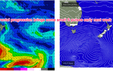
For now, frontal activity is being allowed to track in a more favourable manner for S swell production so we’ll see a week of small/moderate S swell pulses leading into the Easter weekend.
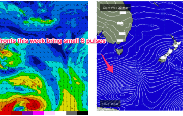
/reports/forecaster-notes/eastern-tasmania/2024/03/22/mostly-small-s-swell-pulses-and-offshore-winds
freeride76
Friday, 22 March 2024
S swells from frontal activity now look a notch more active next week as the W-E progression of the next high cell (and subsequently fronts) slows and allows more intrusion into the lower Tasman.