The high pressure belt remains positioned well to the south with continuing troughiness and NE wind episodes ahead.
Primary tabs
/reports/forecaster-notes/eastern-tasmania/2024/01/10/easing-swells-end-the-week-some-workable-s
freeride76
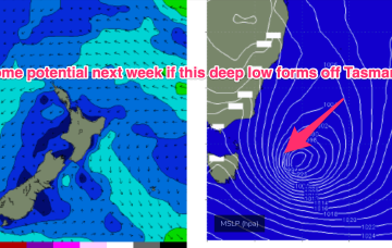
Wednesday, 10 January 2024
/reports/forecaster-notes/eastern-tasmania/2024/01/08/strong-swells-low-near-the-island-easing
freeride76
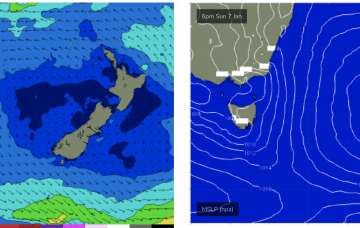
Monday, 8 January 2024
The low east of Tasmania supplies plenty of strong S-SE swell through the short term with an easing trend back to small background swells this week.
/reports/forecaster-notes/eastern-tasmania/2024/01/05/active-period-ahead-ne-windswell-and-low
freeride76
Friday, 5 January 2024
A much more significant increase in NE windswell is expected for Sun as the fetch ramps up down the NSW South Coast and into Bass Strait.
/reports/forecaster-notes/eastern-tasmania/2024/01/03/another-round-chunky-ne-windswell-sun-next-week
freeride76
Wednesday, 3 January 2024
A trough moving north from a position east of Tasmania brings a renewal of the S’ly pattern today into Fri before the summer pattern slowly resets over the weekend. Any large or moderate swell generating features have disappeared from the charts, alas but there’ll be some fun swell sources for NETas.
/reports/forecaster-notes/eastern-tasmania/2024/01/01/small-pulses-ne-windswell-potential-large-s
freeride76
Monday, 1 January 2024
This NE windswell should perk up a notch into Wed as a fetch off the NSW South Coast increases in strength and extends into Eastern Bass Strait.
/reports/forecaster-notes/eastern-tasmania/2023/12/29/plenty-action-over-the-weekend-quieter-next
freeride76
Friday, 29 December 2023
No great change to the weekend f/cast with a weak front having passed the state and a stronger front about to sweep past the Island, bringing new S swell and W, tending SW winds through Sat
/reports/forecaster-notes/eastern-tasmania/2023/12/27/lots-action-close-out-the-year-and-begin-2024
freeride76
Wednesday, 27 December 2023
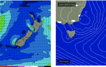
A complex inland trough/low is emerging from the Gippsland coast into the Tasman Sea with a fetch of SE-E/SE winds aimed at Tasmania and offering some plenty of E-E/NE swell, easing tomorrow.
/reports/forecaster-notes/eastern-tasmania/2023/12/25/plenty-action-ahead-low-moves-southern-nsw
freeride76
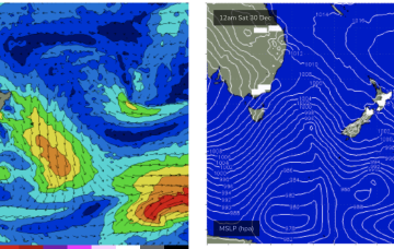
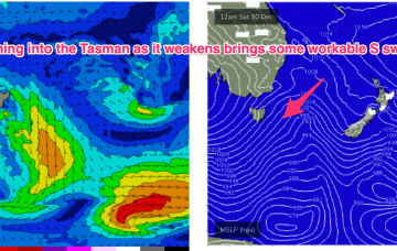
Monday, 25 December 2023
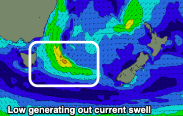
The infeed into the low is focussed on Far Southern NSW and Tasmania before the low moves into the Tasman and drifts SE. We’ll see plenty of E quadrant swell off the infeed. Frontal systems following this troughy pattern should supply S swell of moderate size late in the week and over NYE and New Years Day.
/reports/forecaster-notes/eastern-tasmania/2023/12/22/fun-weekend-surf-onshore-early-next-week
Craig
Friday, 22 December 2023
A good E/SE swell will ease on the weekend with favourable winds. Early next week looks average, improving again later week.
/reports/forecaster-notes/eastern-tasmania/2023/12/20/good-windy-swell-building-late-week-great
Craig
Wednesday, 20 December 2023
Poor surf tomorrow, improving with size and energy Friday with workable options, clean and easing into the weekend. Stormy swell on the cards for next week.