Intensifying pressure gradients between a 1025 hPa high East of Tasmania and an approaching complex mid-latitude cut-off low is seeing N to NE winds begin to freshen across Bass Strait tonight.
Primary tabs
/reports/forecaster-notes/eastern-tasmania/2021/10/13/chunky-ne-windswell-ahead-onshore-winds-problem
freeride76
Wednesday, 13 October 2021
/reports/forecaster-notes/eastern-tasmania/2021/10/11/large-ne-swell-later-week-followed-large-s
freeride76
Monday, 11 October 2021
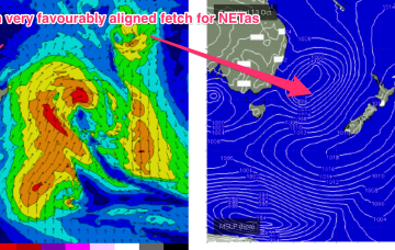
High pressure drifts across the Tasman from a position in Tasmanian latitudes this week. An approaching mid-latitude low in the Bight tightens the the pressure gradient along the western flank of the high in the Tasman, with an increase in N to NE winds off NSW coast through Wed. It’s Thursday and Friday that really muscle up with gales aimed directly at NETas.
/reports/forecaster-notes/eastern-tasmania/2021/10/08/tiny-weekend-solid-surf-expected-mid-next-week
freeride76
Friday, 8 October 2021
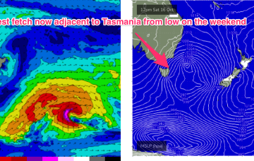
A much more solid swell event then unfolds through the second half of next week , with a high pressure system drifting in the lower Tasman towards the South Island and a strong N’ly fetch developing off the back of the high, with pressure gradients being tightened by an approaching mid-latitude low in the Bight.
/reports/forecaster-notes/eastern-tasmania/2021/10/06/quiet-period-ahead-more-surf-potential-next
freeride76
Wednesday, 6 October 2021
Things get more interesting next week, as instability in the Tasman sea leads to some surf potential for the East coast of Tas.
/reports/forecaster-notes/eastern-tasmania/2021/10/04/windy-week-ahead-couple-days-fun-surf-start
freeride76
Monday, 4 October 2021
The low near the South Island has had a fetch of ESE winds towards Tasmania, not ideally aligned but radial spread from the source fetch should see surf in the fun size range through Tuesday.
/reports/forecaster-notes/eastern-tasmania/2021/10/01/solid-pumping-surf-ahead-when-winds-swing
freeride76
Friday, 1 October 2021
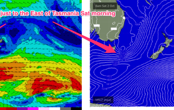
An inland low and offshore trough are generating a mix of NE winds and more proximate E’ly winds both in the Eastern Tas swell window. Onshore winds have been associated with the approaching low.
/reports/forecaster-notes/eastern-tasmania/2021/09/29/plenty-surf-and-wind-low-pressure-drifts-over
freeride76
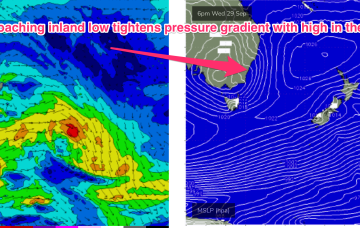
Wednesday, 29 September 2021
Still on track for some large, windy surf for the NE coast as an approaching low pressure system focusses an infeed of E’ly winds onto the coast and an associated NE fetch in the Tasman, adjacent to the NSW coast sends NE swell towards Tasmania.
/reports/forecaster-notes/eastern-tasmania/2021/09/27/tempestuous-week-ahead-onshore-winds-and-plenty
freeride76
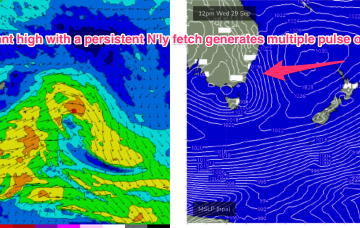
Monday, 27 September 2021
Tempestuous, windy week ahead for the region with a dominant high moving NE into the Tasman, generating NE windswell before an inland low approaches and brings strong onshore winds and large seas and swell.
/reports/forecaster-notes/eastern-tasmania/2021/09/24/plenty-action-the-s-then-ne-next-week
freeride76
Friday, 24 September 2021
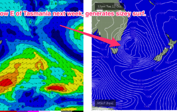
A deep low just to the SW of Tasmania with a strong front attached is expected to transit into the Tasman sea through tomorrow with gales adjacent to Tasmania generating a steep increase in S swell through the a’noon.
/reports/forecaster-notes/eastern-tasmania/2021/09/22/s-swell-pulses-weekend-ne-windswell-next-week
freeride76
Wednesday, 22 September 2021
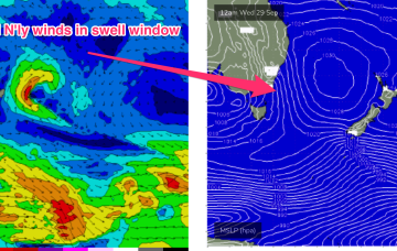
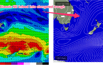
Pressure gradients tighten on Tuesday as a cut-off mid-latitude low in the Bight approaches, with N’ly winds starting to freshen along the NSW South Coast and adjacent waters. This N’ly fetch is expected to be a useful swell source for NETas.