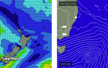
The pattern of strong, zonal W’lies tied to polar lows and embedded cold fronts and weak mobile high pressure won’t offer much north of Seal Rocks but we will see some small S swells generated by gales out of Bass Strait this week with a mostly NW-W flow across southern NSW and NW-N in the sub-tropics. There’ll be a few small windows, favouring the MNC.
Primary tabs
/reports/forecaster-notes/south-east-queensland-northern-new-south-wales/2024/08/26/mostly-nlies-week
freeride76
Monday, 26 August 2024

/reports/forecaster-notes/south-east-queensland-northern-new-south-wales/2024/08/23/not-much-offer
thermalben
Friday, 23 August 2024
There is also a risk of northerlies through this period, but we’ll take a closer look at the specs on Monday.
/reports/forecaster-notes/south-east-queensland-northern-new-south-wales/2024/08/21/time-grovel
freeride76
Wednesday, 21 August 2024
Very spring-like synoptic chart with mobile high pressure moving NE through the Tasman and a N’ly flow across most of the eastern seaboard.
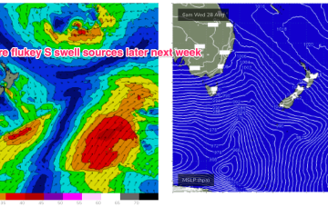
/reports/forecaster-notes/south-east-queensland-northern-new-south-wales/2024/08/19/s-swell-pulses
freeride76
Monday, 19 August 2024
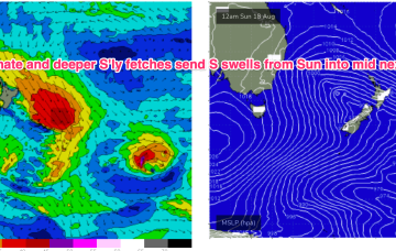
A deeper fetch now operating near New Zealand longitudes is better aimed at Pacific targets (some to Fiji, most to Tahiti) with some sideband S/SE groundswell due through the middle of this week.
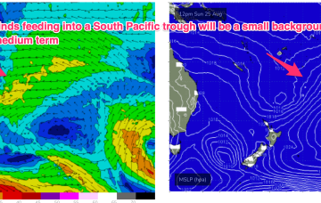
/reports/forecaster-notes/south-east-queensland-northern-new-south-wales/2024/08/16/sly-swells-next
freeride76
Friday, 16 August 2024
We’re still looking at S’ly to S/SE’ly swells next week but the overall evolution of the storms is now not as favourable with more of the energy aimed at Pacific targets.
/reports/forecaster-notes/south-east-queensland-northern-new-south-wales/2024/08/14/stormy-swells-0
freeride76
Wednesday, 14 August 2024
A summer style pattern is seeing tropical moisture dragged down the East coast by a trough and deep E/NE-NE flow from a large high in the Tasman, generating large stormy swells for QLD, grading smaller as you head down the NSW coast.

/reports/forecaster-notes/south-east-queensland-northern-new-south-wales/2024/08/14/stormy-swells
freeride76
Wednesday, 14 August 2024
A summer style pattern is seeing tropical moisture dragged down the East coast by a trough and deep E/NE-NE flow from a large high in the Tasman, generating large stormy swells for QLD, grading smaller as you head down the NSW coast.
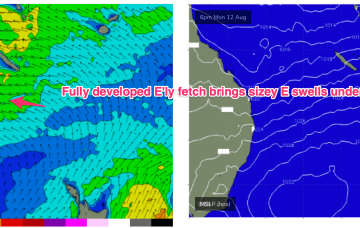
/reports/forecaster-notes/south-east-queensland-northern-new-south-wales/2024/08/12/sizey-onshore-e
freeride76
Monday, 12 August 2024
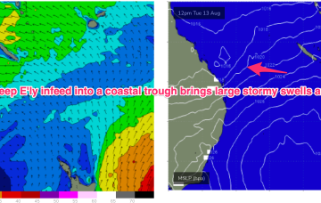
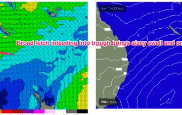
We have a strong (1033hPa) high in the Tasman, with a deep E’ly flow through the Coral Sea feeding into a coastal trough along the QLD coast. That trough is drawing down plenty of tropical moisture in the deep onshore flow, and generating sizey, stormy E’ly swells for the sub-tropics.
/reports/forecaster-notes/south-east-queensland-northern-new-south-wales/2024/08/09/large-stormy-e
freeride76
Friday, 9 August 2024
Most of the swell energy from this system will be aimed at sub-tropical targets, and we will see some real size from the E as winds feed into the trough. Unfortunately, with a straight onshore flow for the peak of the swell.
/reports/forecaster-notes/south-east-queensland-northern-new-south-wales/2024/08/07/few-small-options
freeride76
Wednesday, 7 August 2024
By Tues we see late summer style sizey E’ly swells from a fully developed sea state across the Coral Sea.