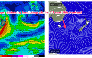
We’ll see some nice strong S pulses over the weekend as multiple fetches operate on an active sea state. Nothing huge but of winter calibre.
Primary tabs
/reports/forecaster-notes/sydney-hunter-illawarra/2025/07/10/lovely-s-swell-weekend-typical-winter
freeride76
Friday, 11 July 2025
/reports/forecaster-notes/sydney-hunter-illawarra/2025/07/08/upgraded-s-swell-outlook-the-weekend
freeride76
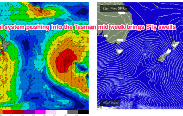
Wednesday, 9 July 2025
Compared to Mondays notes the outlook for S swell is improved, mostly due to a better aligned following front which conjoins the initial front and forms a slower moving low in the southern Tasman.
/reports/forecaster-notes/sydney-hunter-illawarra/2025/07/07/wly-pattern-not-much-surf-until-fri
freeride76
Monday, 7 July 2025
High pressure is well up over the centre of the continent with as weak, troughy area of low pressure moving offshore from the south coast dragging a cloud band with it and offering a W’ly flow in it’s wake. That W’ly flow looks to continue through the working week as a series of cold fronts sweep across the SE of the country.
/reports/forecaster-notes/sydney-hunter-illawarra/2025/07/03/fun-easing-swells-over-the-weekend-not
freeride76
Friday, 4 July 2025
The complex, coastal low is now dissipating and drifting towards New Zealand while high pressure drifts NE to sit over sub-tropical NSW/SEQLD tomorrow before entering the Tasman on Sunday with a broad low pushing across the interior of Victoria and NSW behind it.
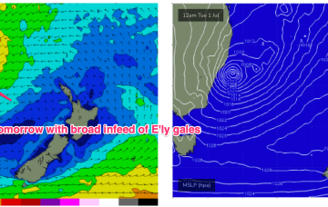
/reports/forecaster-notes/sydney-hunter-illawarra/2025/07/02/more-big-windy-surf-complex-low-remains
freeride76
Wednesday, 2 July 2025
A vigorous coastal low is now moving N, with a secondary low centre rotating around the primary low before forming a dual-centred system, which then slowly moves away from the NSW coast later tomorrow and through Fri.

/reports/forecaster-notes/sydney-hunter-illawarra/2025/06/30/ecl-brings-l-xl-swells-and-severe
freeride76
Monday, 30 June 2025
A Coral Sea trough deepens into a small low and becomes continuous with a NSW coastal trough which deepens today and forms an ECL over the next 12-24hrs. By first light tomorrow morning and ECL or variant thereof will be positioned off the lower end of the MNC, likely due east of Seal Rocks.
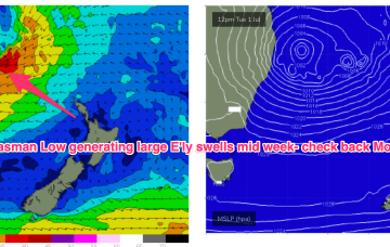
/reports/forecaster-notes/sydney-hunter-illawarra/2025/06/26/fun-weekend-next-week-looking-dynamic
freeride76
Friday, 27 June 2025
Wed now looks very sizey with a full fledged low off the coast, E’ly gales feeding into it and L-XL surf developing along the NSW Central and Southern coastlines.
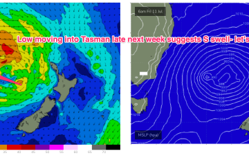
/reports/forecaster-notes/sydney-hunter-illawarra/2025/06/25/plenty-s-swell-short-term-next-week
freeride76
Wednesday, 25 June 2025
More frontal activity through the lower Tasman keeps the southern swell window active medium term while the Tasman Sea now looks like showing enhanced storminess with major models in broad agreement over a large, complex surface low developing and good odds for a prolonged M/L swell event.
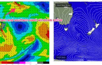
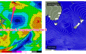
/reports/forecaster-notes/sydney-hunter-illawarra/2025/06/23/swells-around-the-compass-the-radar
freeride76
Monday, 23 June 2025
Despite the travel distance, we should see some quality long range E swell from this source, with some size from the south this week as the front and low traverse the Tasman.
/reports/forecaster-notes/sydney-hunter-illawarra/2025/06/20/small-waves-and-light-winds-the-weekend
freeride76
Friday, 20 June 2025
A trade fetch with a small low at the SE edge of the fetch is supplying small surf to the sub-tropics, with a minor amount expected to slowly filter down into more temperate regions.