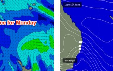
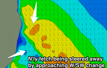
A trough crossing the coast into Monday - linked in with a broad mid-latitude low to the south - will swing winds to the west across the Mid North Coast.
Primary tabs
/reports/forecaster-notes/south-east-queensland-northern-new-south-wales/2017/09/22/gusty-nly-winds
thermalben
Friday, 22 September 2017
/reports/forecaster-notes/south-east-queensland-northern-new-south-wales/2017/09/20/make-most
thermalben
Wednesday, 20 September 2017
More southerly swell is expected through Thursday, and winds will be light and variable early.
/reports/forecaster-notes/south-east-queensland-northern-new-south-wales/2017/09/18/terrible-run
thermalben
Monday, 18 September 2017
The weekend looks terrible.
/reports/forecaster-notes/south-east-queensland-northern-new-south-wales/2017/09/15/easing-sly-swell
Craig
Friday, 15 September 2017
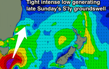
Good S'ly groundswell pulse for tomorrow morning with offshore winds, easing during the day and bottoming out early Sunday. Average winds Sunday with building levels of S'ly swell into the afternoon/evening and peaking Monday morning with variable breezes.
/reports/forecaster-notes/south-east-queensland-northern-new-south-wales/2017/09/13/easing-nne
Craig
Wednesday, 13 September 2017
Clean fading N/NE windswell tomorrow with some good new S'ly swell for Friday with offshore winds, a touch smaller Saturday. Renewal in S'ly swell Sunday but with poor conditions, better Monday.
/reports/forecaster-notes/south-east-queensland-northern-new-south-wales/2017/09/11/unusual-south
thermalben
Monday, 11 September 2017
Strong to gale force W/SW winds trailing the front into the Tasman Sea will then set up an unusual S’ly swell for Friday.
/reports/forecaster-notes/south-east-queensland-northern-new-south-wales/2017/09/09/big-sunday
thermalben
Saturday, 9 September 2017
Today’s upwards trend out of the south is only the beginning.
/reports/forecaster-notes/south-east-queensland-northern-new-south-wales/2017/09/06/sustained-series
thermalben
Wednesday, 6 September 2017
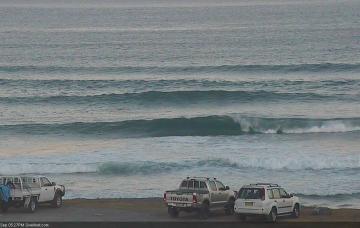
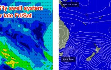
The broad outlook is up throughout Thursday, down temporarily Friday morning, then up again strongly Friday afternoon across the Mid North Coast ahead of a large weekend of southerly swell in Northern NSW, with smaller conditions across SE Qld.
/reports/forecaster-notes/south-east-queensland-northern-new-south-wales/2017/09/04/sustained-series
thermalben
Monday, 4 September 2017
As for new swells throughout the forecast period - we have a very active progression of fronts across the SE corner of the country.
/reports/forecaster-notes/south-east-queensland-northern-new-south-wales/2017/09/01/easing-weekend
thermalben
Friday, 1 September 2017
It’s a relatively straight forward forecast for the weekend - easing size from this point onwards, with light variable winds for much of Saturday, freshening from the north Sunday.