Making the most of our WAMs

Thursday 12/12 12
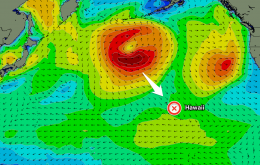
If you haven't stumbled across our Wave Model (WAM) charts you've been missing out on a great forecasting tool. For a great first view of the WAMs, check out this large swell on the way to Hawaii.
If you haven't stumbled across our Wave Model (WAM) charts you've been missing out on a great forecasting tool. For a great first view of the WAMs, check out this large swell on the way to Hawaii.
Last week the North Shore lit up under a large north-westerly groundswell. Sunset Beach pumped for the World Cup of Surfing while second reef bombs unloaded at Pipe in preparation for the Billabong Pipeline Masters.
So what's in store for the waiting period?
This Friday the North Shore will see a large groundswell out of the NW which should produce solid 10 foot sets at exposed reefs. Not only this, the swell is likely to move accumulated sand off the reef at Pipe in readiness for the Pipeline Masters.
Less than a week after the recent groundbreaking XXL swell smashed into Europe, a second XXL swell is on target for the region.
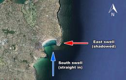
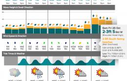
In the coming days the East Coast will be bathed in pulses of southerly swell, and this means there will be a lot of difference in wave size depending on where you surf. It's a perfect time to make sense of our new forecasting system.
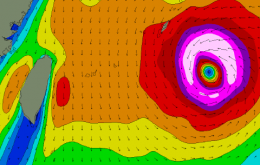
While Australian surfers wait for their cyclone season to begin, the Western Pacific basin has been very active. The latest storm to impact the region is Super Typhoon Francisco and it's expected to push across the Ryukyu Islands of southern Japan today.
The new Swellnet website contains a brand new forecasting system which we've been developing over many years. As a result we are changing the way we deliver forecasting information to you.
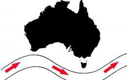
Australia's eastern states have just exited the worst winter surf season in recent history. If you're a Sydney surfer and you've seen a wave over three feet you can count yourself lucky. So, the questions have to be asked: What is causing the recent lack of waves?
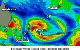
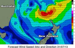
The initial west/south-west swell is still on track, although it has been slightly downgraded in the latest model runs. It has originated from a cut-off low currently located east of New Zealand. The low has a short fetch length and is not expected to last very long, so its swell potential is limited.
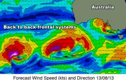
This Victorian winter hasn't been that bad for surfers. The pattern is about to undergo a serious transformation starting this weekend, as the southern Australian coast is slammed by back-to-back groundswells – forecast to persist for nearly two weeks.
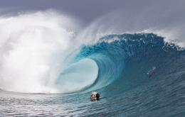
The Billabong Pro Tahiti Trials has earnt a reputation of dishing up some of the heaviest competition waves in the world outside of an ASP World Tour event. So what's in store for this year's Trials which kick off this weekend?
Following a sporadic start to winter, the whole East Coast is on target for a pumping east swell beginning this Friday as a broad belt of trade-winds develop above New Zealand.