An autumnal April

We're over halfway through autumn, but this one's different. Having to stay home and surf locally removed the opportunity to chase surf, but it also allowed surfers to get more in synch with their local. In fact, you had to time the tides and tweaks in swell directions to beat the significant increase in crowds.
But the past month has had a much more 'autumnesque' feel compared to recent years where summer seems to drag on deep into April and May.
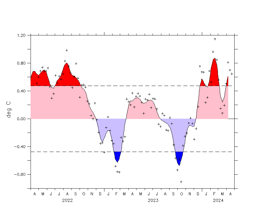
The reason for this, especially across the south-eastern part of the country was a strong negative Mean Sea Level Pressure anomaly for the month of April (purple blob below). This means that we saw much lower pressure than normal (compared to historical data from 1981-2010) spreading from South Australia over to New South Wales, including Victoria and Tasmania.

Mean Sea Level Pressure anomaly (difference from normal) for April
The difference from normal was quite significant as well, down to near 10hPa below the climate average, and the flow on effects for not just the southern states but the East Coast were very noticeable.
The cause of the anomaly was a strong and persistent negative Southern Annular Mode (SAM) through all of April, lifting the westerly storm track closer to Australia.
With such a large low pressure anomaly, the resultant wind anomalies were westerly through the Bight and across Victoria, bringing plenty of westerly swell, though also with plenty of wind.

Wind anomaly (difference from normal) for April
The main beneficiaries from this pattern were South Australia and Victoria. The Adelaide Mid Coast offered fairly consistent surf all month from the persistent fronts pushing up and across Western Australia, though it was to the detriment of the rest of that state (especially through the second half of April).
Victor Harbor enjoyed the winds from the north-western quadrant, while the Surf Coast in Victoria received a steady flow of westerly swells with favourable conditions under zonal westerly breezes. While not especially large, there's been plenty of fun days to pick and choose from.
Tasmania saw swells from west to south and a few point days with much cooler weather than normal, 1.45 degrees below average.
With all this cold windy and wet weather it's no surprise that Tasmania saw its wettest April since 1960, Victoria since 1974 and its third wettest on record. In contrast though Western Australia saw its second hottest April on record linked to interior heat built up with the lack of cloud from the (non-existant) monsoon this summer.

Rainfall deciles for April - note the increase across the south-east of the county
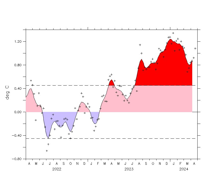
We can clearly see this in the rainfall and temperature charts, and the end result for the nation, even with a cooler south-east of the country was the 42nd consecutive month of warmer than average national temperature, with April being the 5th warmest on record.

Temperature anomaly (difference from normal) for April - note hotter everywhere besides the south-east
The flow on effects for the East Coast has been a switch from the normal easterly trade-swell regime for SE Qld and Northern NSW to diffracted southerly groundswell energy from the Southern Ocean and Tasman Sea. While it's kept most locations busy with swell, we're now staring at another below average autumn of surf for the East Coast unless things change in the coming few weeks, and this looks unlikely.
The north-west wind anomalies through the Tasman Sea tell the story (second image above).
One positive development through April was the build up of heat in the seas off North West Australia, feeding moisture into north-west cloud bands which traverse across the interior of the country and are bringing much needed rain to the more inland regions of the country.
This is set to continue through winter and the models that try and forecast the Indian Ocean Dipole are now favouring a strong negative event. This is opposite to last years strong positive event and will see a wetter winter across the south-east of the country though with the extra cloud cover, warmer morning minimum temperatures.
We'll continue to follow these events as they unfold over the coming months.
Comments
Melbournians have been staying home....not. Meanwhile, in going surf I haven't left my neighbourhood, yet alone my postcode. Literally stayed local and dealt with more crowds than usual.
Crowds up everywhere due to our Minion government listening to thier superiors and sacking everyone....
At least there’s been waves
Today felt like classic Autumn but the other weeks especially last week felt like the middle of winter.
good wrap Craig.
Very nice.
I think negative = positive here?
Thanks for the info.
Be nice if we had temp anomalies for winter and it gets nice and cold...it'll be about the only thing outside of a seal colony start-up to regulate the covid crowds.
The surf this autumn has without doubt been a lot more consistent
than 2018 and 2019 I remember last year riding a foamy straight for
over 4 weeks in autumn because of lack of size. South Sydney area.
The crowds are boarding on insane thou. A lot of aggro.
Yep plenty of south swell, though I look forward to swells with east in them this time of year..
"...the models that try and forecast the Indian Ocean Dipole are now favouring a strong negative event. This is opposite to last years strong positive event..."
Will this mean less trade winds in Indo this season Craig?
I seem to recall last years strong positive event resulted in strong consistent trades all season?
Yep. More winds from the W-NW.
Cheers Craig. Guru. Would this be applicable to the whole archipelago? East and west of Bali?
I'll leave these here.. Last significant event, 2016..
Wind anomalies July through November


Gee's..... thanks mate. Now if only I could organise a flight!
Thanks Craig. Do those charts suggest not much trade wind for Nusa Tengarra?
Yep more variable.
Where do you find the current SAM values? I was trying to find them the other day.
Cheers.
Here ya go.. AAO Observations Click Ensemble Mean Forecasts below the graph for forecasts.
Thanks man.
Great write-up Craig, thanks for your work.
Thanks guys. Really enjoy these analysis articles.
Thanks Craig, love these climate driver articles. Has the neutral ENSO played any part in this strong negative anomaly for the south east of Aus or has it really just been driven by the persistent negative SAM?
Great insight and a reminder to the travelling masses that after speaking to a local Torquay copper they will be working hard this weekend on people travelling and the fact that we had a shark attack at Southside this afternoon so not just the locals are cranky.... guy is ok with a few scars to tell his grandkids about
Thanks Craig, I like the long term climate forecast and analysis articles. April has been really nice on the GC, it's definitely my favourite month of the year. Normally I'd cross the border on the weekends in search of waves but the last week in particular I've enjoyed the travel restriction and surfing close to home. It's been pretty crowded but I reckon the average surfer seriously underestimates how many local surfers there are. Sounds like SE QLD is on track to 10 months of spring time conditions and 2 months of winter. It'd be great to see some wave height and direction anomaly charts to do a reality check on perceived swell quality.
Does this forebode a bumper snow season? Has anyone ever cross-referenced the SAM results (and others?) against the falls recorded at the major ski fields?
Back when I used to hit the slopes more regularly, it always felt like NZ/Aust. would take turns having good seasons. A reflection of how far north those southern ocean systems push up into the continent? If not they seem to keep going east and drop their load on the long white cloud...
So the negative IOD means there'll be lots of moisture inbound to the mountains but.. will it come with cold air.
2016 saw lots of washouts but also big dumps. Just depends which side of the coin we fall and that's too hard to forecast.
Yeh totally agree. Unfortunately, Australia's highest elevation points are right on the cusp of the freeze/rain line at our southern latitude, you'd need much higher mountains above sea level for us to get consistant and/or quality snow.
Speaking from vast experience, best save your coin and travel O.S (when restrictions are lifted) if snow sports are your thing, it's far superior elsewhere in everyway, plus you get to see other amazing parts of the world.
Australia's bloody great for surfing but!
so far nothing will compare to Niseko for me (mind you I've never been to Sth America or Canada and only Switzerland in europe).
Yep Hokkido is excellent, truly a standout and a prime spot for intermediate-advanced skiers/boarders, my favorite is Big Cottonwood Canyon, 'The Greatest Snow' and terrain on earth but more for the advanced-expert (Crazy terrain).
Ahhh, the memories..... :)
Does this mean we will see more Southerly groundswells around 2m+ then last year for the Sydney Area?
Regarding the impact of the IOD on swell outlooks, there's no studies or data currently available to make any long-term calls in this area unfortunately. Only the local wind regimes for the tropical Indian Ocean region.
insane afternoon crowds on the peninsula..like being at the public pool on a hot summer day heads kids every few metres..dunno what happened to home school..early mornings were the go during iso
another factor in the crazy crowds is the fact that there is no other kids sports and activities on at the moment - footy, soccer swimming dancing, ballet and what ever else they do is canned/kid, so every family is heading to the beach.
Yep agree, with all those other sports and activities not available it seems they've all grabbed the nearest board and paddled out.
For sure. There would be 1000+ footy players across all ages on the peninsula alone. If 10-20% are surfers that’s a big increase on the few spots that are working during the weekend when they would normally be playing
Autumn......you fucken little beauty.
Starts out as a welcome reprieve from the summer crowds and North Easters and just gets better. Windless days with warm water and fun waves. Temperature goes down a notch and the sweaty summer nights - bless their souls - are replaced by a comfortable night without tossing and turning. Oceanic currents which look like they’re borrowed from Fiji grace the nearshore waters.
Then we hit Anzac Day and the water temp gets a bit less tropical. The pelagics are still going nuts but there’s a bit of everything getting around in the ocean . All kinds of tasty fresh produce ready for harvest. Days are still gorgeous although you may start to put on a jumper when the sun isn’t around.
The definition of pleasant abounds . Weather , air and water temperatures. No Easter crowds this year was like the second coming itself. The sky reaches peak blue for the year.
Then we are into may and tailing into winter. Nights are just chilled enough to snuggle without your balls bolting into your stomach when you’re confronted with leaving the doona for a midnight slash , but you wouldn’t want to prolong the exposure. Southerly winds are forcing rubber in the surf. Sneaky snapper are moving inshore amongst the Northbound pelagics.
The first whales appear.
Crowds are low. Surf quality is high. Life is damn fine indeed.
Then a delicious preliminary taste of winter. Rugged up proper. Every excuse for a slow morning. An extra hot coffee and maybe a hot second breakfast tacked onto the warm weather fruit bowl. Early sunset. Due south swells.
Thanks for another epic Autumn, Huey. Always your best work.
Batten down the hatches , Jon Snow. Winter is coming.
Craig...these weather analysis are a highlight of the site.
Keep ‘me coming please legend.
Sorry i tried to post the other night but had a password issue .
You guys are barking up the wrong tree . Yes the Eastern Indian and off our NW shelf has had above average SST's . But it is more of a resultant of little to no Cyclone activity off there through what was a failed wet season this year .
Of interest in the last few weeks has been a warming trend off the Kenyan and Somali coast . So the IOD has seen warm on both sides of its analysis region . Only the thing is the Western region has been rising faster . Plus we have now seen a cyclone / hurricane form in the Bay of Bengal . When a large one forms in May , its almost a certainty that it will trigger a movement towards a more Positive IOD .
More of interest in the Oceanic infuences in the last few weeks / month is we about to see a La Nina form in the Pacific .
I know everyone on the east / south coasts have seen their share of rains already . This a resultant of the previous IOD Eastern warm waters , a stronger SAM and zonal LWT stall in this region for the last few months as per this article .
Some argue that NSW's late summer rain etc is a resultant of the ENSO trend rather than the actual figures . So the rains are a resultant of the ENSO peaking in El Nino territory and then sharp drops . So a downward trend . Others more far will argue that fires here and resultant cloud / OLR reduction results in a Cool water downwelling .
Fast forward to the last few weeks , and the Equatorial Pacific subsurface current has seen a significant cool plume migrating East , altering the thermocline and already starting to erase warm surface anomalies in the far East Nino 1 region . In th next week we will see this region go strong Cool anomaly . We have already seen a shift in warmer waters west in the Paciific . this will srupercharged in the next few months with stringer Ocean Basin wide Trade anomalies . So coupled with the wet year already to date , a wet late winter / Spring and likely summer could see significant flood events . Maybe too late ECL influences , but hopefully not . And hopefully string enough to continue into the Southern cycle season . Without too many land crossiings for QLDers . Buckle up kids .
Great analysis. Why then are SW reports so useless? So terribly wrong and your clearly using data from BOM. I wonder if premium access reads a separate report to free access?
right with you there Southey and good to hear from you again.
this past of NENSW is very susceptible to changes in ENSO and it's more often the trend or direction of movement towards one or other part of the continuum, rather than the actual state itself which is the determining factor.
the weather state seems to wag the dog, ie be the indicator, rather than the result. If that makes sense.
Hey Southey, thanks for the additional info and good to see you back.
I didn't mention the cause of the warm waters off NW WA, just pointing out that that's where the supply of moisture is coming from, feeing in and across the country.
Also not sure if you saw these articles but I've mentioned that +IOD events are more likely with the faster warming in the western tropical Indian Ocean here.. https://www.swellnet.com/news/swellnet-analysis/2020/02/18/new-research-...
And while yes it is slightly warmer further over west at the moment, it's not until winter that we'll see the true IOD signal creep in. All models have a - IOD event forecast into July, full blown into August.. we'll see. http://www.bom.gov.au/climate/model-summary/#tabs=Indian-Ocean
Here are the SST anomalies for the south-east tropical Indian Ocean and western tropical Indian Ocean. A good tussle.
South-east..
Western...
RE the Pacific looks like we are trending to a La Nina event.
Also thanks for the kind words Blowin and Sharkfin.
Sorry Craig .
Wasn't meaning to correct you . Just trying to point to two facts that will have more influence on our weather moving forward . Namely the Cyclone forming in in Bay of Bengal and the Pacific in the process of flipping .
And yeah Steve , you often have a way with words that my numbers brain can't fathom .
I would truly love to banter with you guys more often , but as you can see . I don't even have time to edit my posts for grammar .
Okay , here's something for the people heavily into Indo seasonal weather . And for others interested in the IOD's effects on Aust winter - Spring .
https://www.tandfonline.com/doi/pdf/10.1111/j.1600-0870.2007.00254.x
Yep, copy that. Will read that through the week, looks interesting.
Thanks Craig, great article! Thanks too to Southey for the prognosis, good to hear your views. So we have had lower pressure than normal over Tassie and the SE, westerly wind patterns giving repeated swells, colder temps than average over the SE, warm water off NW WA which may bode well for more precipitation and snow in winter, and a La Nina forming. That's about my usual weather list to Santa each Christmas. Very happy !
Question: the westerly flows, strong positive SAM: could this be an ongoing thing after the SSW event in November?
Swell wise, a few have been a bit too west here, the ones that went up and hit Adelaide. But pretty good overall.
I think you meant westerly flow, negative SAM events regarding the SSW event last year.
But no, I've heard it's more linked to the MJO.. Interaction between the MJO and Polar Circulations.
"Interestingly, during the boreal winter (Southern Hemisphere warm season), strong MJOs in the Indian Ocean are related to a decrease of the AAO index, and AO/AAO tendencies are out of phase."
Interesting and I love how this is all still being discovered.
Yep, -SAM & westerlies, so this is different then, cheers Craig.
And ENSO .
https://www.cpc.ncep.noaa.gov/products/analysis_monitoring/enso_update/h...
So many facts here I dont really understand but find fascinating.
My big question is why so few cyclones off the east coast this year?
not just this year , numbers are down as a trend.
I couldn’t follow the science but there was a suggestion that climate change would lead to reduced cyclones off Queensland, which does sound counter intuitive.
This is the BOM data showing gradual decline in cyclones off Australia.... Be interesting to seperate the Qld data from WA though as they still seem to get plenty.
http://www.bom.gov.au/cyclone/climatology/trends.shtml
Reduced frequency yes, but increased intensity, severity and unpredictability.
Speaking of increased intensity, is the warm water off the NW responsible for this beast, about to smash India?
https://www.windy.com/articles/cyclone-amphan-is-intensifying-and-moving...
That's the Bay of Bengal system Southey was talking about. But no not linked to the warm water off NW WA.
What about the system that is forming SW of Sumatra . Its going to feed off cross equatorial flow from the BoB system . And eventually possibly make landfall around our NW . That is an uncharacteristically late system and due to the above average SST's it will maintain intensity till quite far south .
The reasoning i posted about these systems is the handbrake they will place on any chance of a Strong Negative IOD this season .
that current NW cloud band looks very, very neg IOD to me Southey.
and if it looks like a duck.
A thing of beauty!
thats the second or third big one already and we're still in May.
Bring it! It truly is beautiful. What does Bodhi say in 'Point Break'? "Mother nature makes us realise how truly small we are."
Absolutely rad hail storm 1:20am last night. The initial hail woke me, as if out of nowhere, sounded dry and fell as 5cm x 1cm rectangular shapes. Then more traditional hail with some twice the size with clear ice around the white hailstones. Lightning everywhere and power went out - I was watching it out the front door and copped a horizontal lightning bolt straight overhead with no sound delay, scared me into shutting the door real quick! At the same time the Ms was getting up the youngest and he reckons the hallway was empty in one flash, then mum was there in the next big one - like one of those horror movies haha!
Power went out in the big close flash. Near the front door had an accumulation of white snow-hail, and I noted with some satisfaction a sprinkling through the lawn, always wanted snow at sea level here, and getting closer to it. Veggie garden survived hailstones intact though maybe I lost a few of the recent seedling transplants. The radical extremes continue, the number of sunspotless days continue, and the old school winter continues down this way... The lightning was close - wonder what council permit is required to construct dolmens in the yard...