The Secret Life Of Great Circle Paths

A friend recently returned from a trip to Tahiti sporting all the hallmarks of a successful surf mission: suntanned limbs, coral-shredded feet, and a glazed look in his eyes that spoke of sustained euphoria and the long tail of contentment - his calmness was monastic. And yet just two weeks earlier his disposition was agitated and tense; there he was, about to fly to Tahiti with nary an isobar offering assistance in the swell window south of Tahiti.
So he flew into Papeete with low expectations, and understandably so. Yet he flew out of Papeete in a state of serenity from gorging himself on days of long-range, high plus waves at Teahupoo. His only complaint was inconsistency, at times the sets were up to ten minutes apart, but with few people around he simply slowed down and matched his rhythm to that of the swell. A trick that no doubt contributed to his state of grace.
But where did the swell come from? The expanse of ocean immediately south and west was barren of storm activity.
The answer to that - at least the most likely answer – was Teahupoo's Great Circle Path. A Great Circle Path is the shortest distance between two points on a spherical surface, and when projected on a rectangular map, takes the form of a curve.
If we look at the map below and draw the shortest apparent distance between Madagascar and Tahiti, a straight line as-the-crow-flies approach would be wrong. It's actually the red curve shown below that represents the shortest distance between those two points. This would also be the route planes take if flying between the two locations. For instance, the Great Circle Path between Sydney and Johanessburg is the 'polar route' that flies over Antarctica.
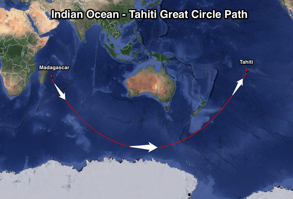
What this also reveals is that any storm or fetch generated in line (parallel) with the red line will generate swell aimed ideally for Teahupoo.
Yes, incredibly, a fetch of north-west winds off Madagascar, aimed towards Antarctica would generate a swell that would travel south-east towards the polar shelf before curving under Australia and then back up towards Tahiti, arriving from the south-west.
Unless the storm was very significant, the swell would lose much of its size due to swell decay travelling such a large distance, and also be inconsistent, but with nothing else in the water, it'd provide waves when there otherwise wouldn't be any.
If we look at one of the Great Circle Paths for Fiji we can see that a similar but slightly different storm track is evident.
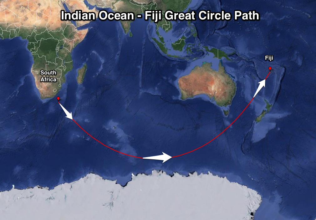
Storms forming more immediately off South Africa rather than Madagascar aimed towards Antarctica will travel towards the polar shelf before bending back up through the Tasman Sea and towards Fiji. The swell window south-west of Tasmania is Fiji's prime swell window, with all the largest swells produced in this area.
Another interesting Great Circle Path is the route from the Southern Ocean to Puerto Escondido in Southern Mexico (see below).
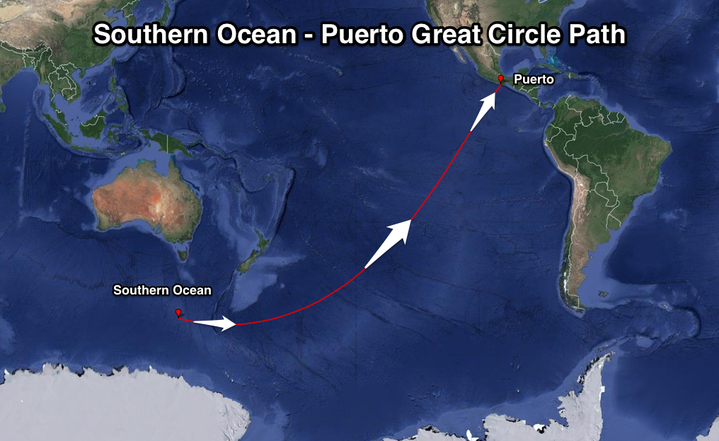
A storm forming south of Tasmania, generating winds aimed to the west will create a very long-range and long-period groundswell for Puerto. Large swells that impact Tahiti, continue onto Mexico if generated in the area shown above, arriving a few days later but with just as much power.
There are Great Circle Paths for every surf spot on the planet, but most of these are intersected by large land masses or continents, rendering them useless for swell forecasting. Others are more straightforward and not too far off what visually looks to be the straightest line between two points.
The usefulness of Great Circles for surf forecasting comes in telling whether a storm's track and orientation is along or perpendicular to a certain locations path. If it's parallel/along it, you can expect the location to receive the bulk of the size, while if perpendicular it's not ideal at all for swell generation. //CRAIG BROKENSHA & STU NETTLE
Comments
Here's one of my faves - SW of Heard Island to Vancouver Island, Canada.
It's a super narrow swell window that passes between Kaui and Oahu (!) and also pushes very close to Fiji too.
The Great Circle path on this particular chart is over 19,000km - in fact I couldn't track the left data point any further west because it would have gone past the half way point (literally the other side of the planet) - so the software started to re-route great circle down under South Africa and through the Pacific Ocean (being a 'quicker' Great Circle path).
But I've mapped this before somewhere many years ago, and if I recall correctly the swell window passes very close to South Africa and moves up into the South Atlantic Ocean, maybe even the North Atlantic? What would that be - 25,000km? More?
In any case, it suggests that an enormous super strength storm off Sierra Leone (or thereabouts) displaying broad, sustained hurricane force NNW winds could theoretically generate a swell event that would pass under South Africa, skirt the Antarctican continent, shimmy between Australia and New Zealand, whisk past Fiji, then sneak between Oahu and Maui before making landfall off the NW tip of Vancouver Island.
And I bet - at the end of it, the tide would be all wrong, and the friggin' onshores would still kick in early anyway.
very interesting. Do you have any other great cycle paths known for well known locations ? e.g. are there any for the Indo archipelago.
There are some for Indonesia, though they're not quite as impressive as those listed above.
One thing to consider is that every meridian of longitude is a Great Circle (i.e it runs through the poles and the centre of the Earth), therefore swells that are travelling north or south are already following Great Circle routes. When Indonesian swells arrive they aren't that far off north so, as mentioned, the paths aren't as impressive.
Still, there are paths that begin well into the South Atlantic and connect with Indonesia, which is further explanation of why it always seems to have a background swell running.
Id like to see a series of this about Australian and Indonesian circle paths, that would be great.
Easy to plot 'em yourself using Google Earth.
Can you explain in relatively simple terms how one might go about plotting them on Google Earth Ben? I'd be keen to have a bit of a play.
Just use the line/distance plot tool.
Start at your surf spot, then zoom out and move the other point around to see the different curves.
Thanks Craig. Bit of an eye-opener when you start playing with it.
i'm confused as fark but very interested.
Are there any historical examples you could show us of these mega long range swells making good waves at these places?
Best article I've seen for ages fkn amazing
It's easier to understand if you use a globe.
Bells gets swell from the North Atlantic but to see a swell of prob 3ft wsw @ 17secs you need about 50ft @ 17secs in the North Atlantic aimed perfectly between Cape Verde & Senegal, duck under south Africa & skirt along the Antarctic shelf. And then when it finally gets here it will be maybe 1ft and incredibly inconsistent. So if there is any other swell in the ocean you're not going to notice it.
Bend it like Beckham.
Amazing stuff.
That plot from Heard to Vancouver is incredible stuff.
Does this account for why you're flying over the Southern Ocean between Perth and Sydney ?
I'm calling Stu has pushed into the top three surf writers going .
Doherty has got great angles and wordplay , but Stu just has the broadest range , intellectual backup and even handed approach.
Jock Serong rounds out the three.
Shearer goes well when he has a go...get into it !
That's some intriguing shit right there stu, so did you have a go at hindcasting the fetch that generated the swell in Tahiti for your mate?, it'd be interesting to see the weather maps of the Madagascar region that were responsible
Nah, didn't have the resources to go back and check, which is a shame cos it'd would've been great to have that definitive proof.
Also, the swell need not have originated as far away as Madagascar; any storm that forms along the Great Circle Path, and is heading in the same direction, will strike Tahiti. Meaning storms in the deep Indian Ocean, or far south of WA, places we don't immediately look for Chopes swells, are effectively in their swell window.
Fascinating and infomative. Love these articles.
Any significant circle paths in the northern hemisphere?
I'm guessing those big winter storms that form off Hokkaido or the Kuril islands and send north swell to Hawaii or northern California? I'm guessing they don't have to travel as far as the southern ones so the rate of decay would be less and that's why Hawaii gets consistently huge?
Wow trippy, i guess the earth is no flat after all.
Wowzers. Too ease my curiosty for the next 9 hours before i can get in front of a computer, for Vic, is there a slight circle from SW of WA to our swell window? Ive always wondered how its possible when you say W/NW winds creating our swells? Does that fetch travel along a slight circle?
Yeah, totally, check this Great Circle.
Any W/NW fetch along this line is right in Victoria's W/SW swell window.
Remember fetches can be slightly off this line but still generate swell, just not to the full potential.
Hey Ben does that explain NSW's Southerly Swells from last week, was there a storm in the eastern pacific sending swell on an eastern arc GC?
Doing an article on it right now. I think it originated from the Southern Ocean.
Furthermore could this theory also explain JJF's world title success in Portugal, originating on the North Shore, bending under Chile and straight past Gabby in Brazil?
ballbag, since the circle paths are not theory but fact, there can be no other explanation for jjf's victory
Cool stu.
"A Great Circle Path is the shortest distance between two points on a spherical surface"
Easiest to think of as it being a straight line. It actually is a straight line. Just seems easier to understand when you think of it like that. The swell isn't bending anywhere, just moving straight, it's the farking map thats bent. :-)
Grab a globe and use your mum's tape measure from her sewing kit.
Now, go play with Einstein's theories on gravity bending spacetime.
Cheers Craig & Stunts. A salve for the land-lubbin' goings-on Stateside