Pam's long lasting scar

 Earlier this week Tropical Cyclone Pam produced the biggest north swell in years across New Zealand while also sending a day of quality waves to Australia's East Coast.
Pam was responsible for approximately twenty deaths across the small island communities south of Vanuatu. It also caused widespread damage which will take many months to recover, but that's not the only trace of her existence. Pam also left a trail across the ocean which will be seen for weeks to come.
Tropical cyclones feed off warm sea surface temperatures. They suck the energy out of the ocean in a continuous positive feedback loop which is only stopped either by strong upper atmospheric winds or if the cyclone moves into cooler waters, generally below 26.5 degrees.
Storm-force winds associated with Severe Tropical Cyclones (STCs) such as Pam also mix up the water column, allowing further energy to be extracted from deep beneath the sea surface. High rainfall along with the energy extraction leaves sea surface temperatures much cooler than they were prior to the cyclone's passage.
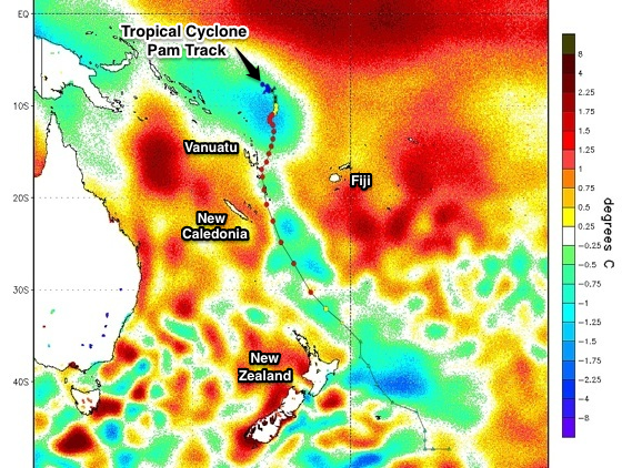
This is shown clearly by satellite observations of the sea surface temperature anomalies in the image above.
A sea surface anomaly is the difference between the current Sea Surface Temperature (SST) and the long-term average, providing a good visual representation of the oceans current state, whether that be cooler or warmer than normal.
In the picture above most of the Western Pacific Ocean is warmer than average shown by yellow to red shadings, but a mint green path from north of Vanuatu down past New Caledonia, finishing off New Zealand's East Coast can clearly be seen.
This shows the rough track STC Pam took - overlayed on the image as the black line with coloured dots – simply by way of the cooler ocean temperatures left in its wake. Four years ago Severe Tropical Cylone Yasi left a similar signature through the Coral Sea (read our article here).
Over the coming weeks the ocean will start mixing again, hiding the scar left by one of the strongest and largest swell producing systems in the South Pacific in quite some time.
But the devastating effects of STC Pam across the Vanuatu region will be much longer lasting. //CRAIG BROKENSHA
If you'd like to donate to the communities affected by Tropical Cyclone Pam you can do so through here: Oxfam
Comments
Hi Craig,
I have a question about cyclones, and I've understood that they are unreliable things from reading the forecast notes, but what constitutes a cyclones track? Or actually any weather system thing for that matter?
Does it aim for where ever there is warmer water? Is it the influence from other high/low pressure systems? upper atmospheric winds?
Thanks!
A cyclones track is the path the eye takes, calculated from satellite and land observations.
Forecast tracks are made by hi-res computer models taking in all the latest available information.
Cyclones are steered by the upper atmospheric weather patterns and can't aim towards warmer water. If they could we'd be in real big trouble!
how can high atmospheric winds stop a cyclone? Say its sitting and feeding over 31 degree ocean temperature, will high atmospheric waves tear apart the circulating winds around the eye leaving the hot water bred storm just as a low/ecl/trough.
And if this system keep moving over hot water it could re develop. At what height and strength are thes winds capable of nullifying a cyclone. Any info u can u redirect me to about this would be greatly appreciated, thanks, the rave
Craig's reference to 'strong upper atmospheric winds' is measured as 'vertical shear' (which is the difference in wind speed with height). When a tropical cyclone encounters high vertical wind shear, the strong winds usually tears the cyclone to pieces. Here is some light reading (or, for a quick summary, try this Wikipedia entry).
geezus, this windshear is an amazing thing, i wonder why it's not studied more, especially about its ability to generate and prolong thunderstorms
Thanks for the links! Super interesting reading.
Also Erik the Coriolis Force wants to steer things to the left in the Southern Hemisphere, so if the cyclone starts heading south and there's no blocking ridge to the east etc then it will generally be steered SE.
Cheers Craig!
Does that mean that us on the east coast should be busting the steamers out early?
Not at all, see all the warm water anomalies on the East Coast. Toasty!
The cool water is over in the Western South Pacific.
I'm betting Pam left some pretty tasty scars on the coast from Gisborne to Wairarapa over in Enzed.
great read
Energy from the weather is an amazing spectacle to say the least.
Pam showed up on SN's wams a couple of weeks before, which was interesting following the changes in the models of its track over that period. SN's models were pretty close IMO. Not once did Ben and Craig stray from their forecasts, which were spot on as well. Nice work.
Still time for another to brew, will be interesting what side of the split line that Pam has made, if one forms in a few weeks....
Good read Craig cheers.
Interesting looking at the picture of SST's in the previous thread regarding Yasi, seems to be vast amounts of warm water ENE of NZ compared to SST's from PAM...
Anyone?
"Tropical cyclones feed off warm sea surface temperatures. They suck the energy out of the ocean in a continuous positive feedback loop which is only stopped either by strong upper atmospheric winds or if the cyclone moves into cooler waters, generally below 26.5 degrees"
..hypothetically, can you infer from this if ocean temps continue to rise to a point consistently above 26.5 deg that you could possibly see an endless self-perpetuating cyclone?
Sometimes we see cyclones persist for long periods of time. In fact, STC Nathan is a good example - low shear and a lack of steering winds has resulted in this system meandering about the Northern Coral Sea since March 9th (it's crossing the coast right now, so that's 11 days of circlework).
Why's the west coast of NZ got such high SST anamolies at the moment?
Jeez, that is warm - especially around the SW region of the South Island.
I'm not sure what could have triggered the anomalies - I initially thought perhaps a sustained period of NE winds across the country, instigating a reverse Ekman transport (because most of the East Coast also has a thin coastal strip of negative anomalies) however I just scanned the last two weeks of ASCAT data there's been a distinct lack of frontal passages through that area (which have a direct influence on wind stress).
Very interesting indeed. I'll sniff around to see if we can find any more info.
The major point to emphasize here is that interannual
MSW and ZSW anomalies appear to be in thermodynamic
equilibrium with the underlying interannual SST
anomalies during autumn–winter, Consistent with
this, autumn–winter temperature anomalies over New
Zealand come into thermal balance with contemporaneous
SST anomalies, the latter slowly propagating eastward
into the vicinity of New Zealand in association
with the ACW, heating New Zealand temperature
through anomalous SST-induced sensible heat flux from
the upper ocean into the lower troposphere.
;)
No takers on that one eh...?
Southey old mate, come on;)
expect an earthquake of magnitude soon don, it may come out of sheepy's arse, but lets just see
Could also just be the downstream effects of the East Australian Current which splits in two around Sea Rocks and heads east over to NZ.
So the heat is taken out of the ocean. Heat is a form of energy, and therefore cannot be lost, (sure it's not a fully closed system, but getting that way) the heat energy is just transferred, to the only other place for it, the atmosphere.
So essentially cyclones are just thermal transfer systems.