From Asia to America: Typhoon delivers widespread swell

In the coming week a rare event will take place in the North Pacific ocean: effectively every country in the region - from the Solomon Islands clockwise around to Mexico - will receive swell from a sole source. That being Super Typhoon Nuri.
It was just under a month ago that Japan received a huge swell from Super Typhoon Vongfong, while at the same time Hawaii's North Shore saw back to back swells bring Pipeline to life.
These were separate and isolated swell events but signified the start of the North Pacific swell season.
This time around though we'll see Super Typhoon Nuri, currently sitting east of the Philippines, deliver swell to the Solomon Islands, Papua New Guinea, the Philippines, Taiwan and then Japan before tracking north-east and being absorbed into the Aleutian storm track.
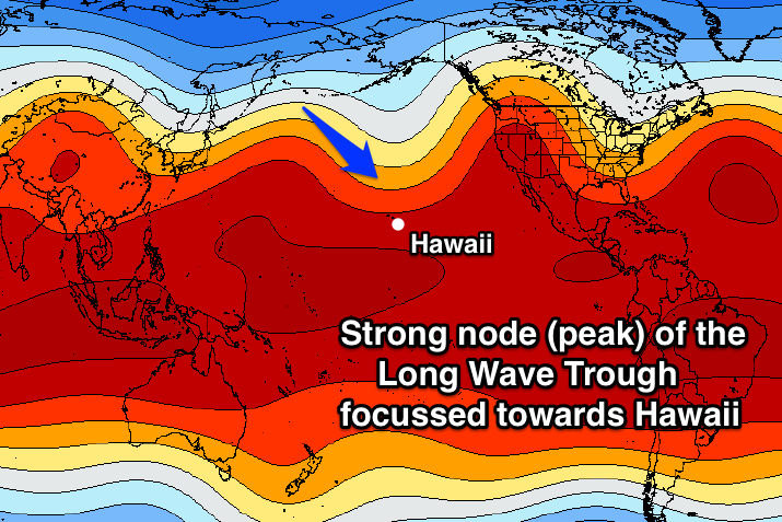 Couple this with a strong amplification (peak) of the Long Wave Trough across the North Pacific and Nuri will restrengthen and deepen significantly, before 'bombing' off the Aleutian Islands.
A bombing low is a weather system that drops at least 24hPa in central pressure in a 24 hour period. This system is forecast to drop from 960hPa down to an incredible 924hPa during Saturday.
This will subsequently establish a fetch of severe gale to hurricane-force winds aimed towards the North American mainland, but also well inside Hawaii's swell window. Although the low will weaken during Sunday a broad fetch of severe-gale west-northwest winds should continue to be aimed towards both regions for a couple of days.
A prolonged large N/NW groundswell should result, arriving across Hawaii through Tuesday next week, building to a large 10-15 foot through Wednesday before slowly tailing off Thursday. The same swell should arrive across the Northern Californian coast mid-late next week.
This won't be the end of the activity either as the Long Wave Trough remains focussed towards Hawaii well into next week, likely generating large follow up NW groundswells well into the middle of November.
Hopefully we continue to see the swells delivering into December for the title showdown at Pipe.
North Shore Forecast
North Shore WAMs
Comments
Gee, she get's whisked away to the NE very quickly after she bombs.
Think you've got it a little mixed up Don. Nuri bombs after tracking north-east and then stalls across the Aleutians.
How's this Infrared image courtesy of NOAA

Cosmic!
Going to be some tasty waves around in the next few days.
So boys are these things stronger than a cyclone pound for pound or much the same?
Same kind of system, just a different name.
whats the difference between a Typhoon and a Super Typhoon?
It's all about the strength of the weather system.
Super Typhoons are only classified when sustained winds around the system are over 100 knots.
Similar to how cyclones are upgraded to Severe Tropical Cyclone strength when sustained winds reach over 107 knots (Category 5 cyclone).
Super Typhoons wear capes
ha
Dam, will miss it in PNG by a few days :(
These things were around all the time in the 70's .... thanks to the good captain and his H bombs
"Typhoon Nuri is on the brink of an explosive transformation and rejuvenation unlike anything I’ve seen in all my years of storm watching."
Bombs away!
http://www.washingtonpost.com/blogs/capital-weather-gang/wp/2014/11/05/bombs-away-north-pacific-storm-to-explosively-intensify-in-historic-fashion/
Another impressive chart we've got is the upper level jet-stream winds.
While down at the surface the 'bombing low' is expected to produce hurricane-force winds up to 65kts, in the upper atmosphere winds will be much stronger and up to 180kts as shown here.
The scale starts at 40kts with the light teal and increments 10kts per contour. Hawaii is towards the middle bottom right.
Incredible ASCAT return from last night.
Looks like a lady wearing a pair of psychedelic tights.
Too true, ha!!
Likely to go into the top 5 strongest storms ever recorded in the North Pac.
Interesting that surfline calling XL, but downplaying an XXL.
head of the fetch not close enough. Fetch aimed slightly NE of Hawaii.
Been a lot of varying forecasts from this system, some writing it off and only calling 10ft, yep 10ft!
Pat Caldwell from NOAA is forecasting 20-30ft faces Tuesday evening, peaking overnight and easing from 18-22ft faces Wednesday. That's in line with our forecast to 12-15ft late today and dropping 12-15ft down to 10ft+ through the evening.
Even though the strongest winds were not ideally aimed towards Hawaii, a much broader fetch of 35-45kt+ winds were still aimed towards Hawaii for a considerable length of time.
Should reach 15ft easy, with bigger sets at offshore deep water reefs.
Also what's the difference between XL and XXL? I thought it just went from 15ft to XXL.
Buoy north-west of Hawaii is registering 16ft of pure groundswell @ 17s, that's nearly 5m!
Will kick very strongly today.
Are you guys putting together jetstream charts now?
Yeah we are, not available yet, but have those and the Long Wave Charts ready to go.
Waimea cam is starting to show a bit of size but untidy. Explore.org
do you know what that low dropped to into hecto/millibrars?
Estimated at 924hPa, but lowest recorded by an actual buoy was 929.8hPa.
That 924hPa is what GFS (American) forecast when I wrote the article 5 days before Nuri made the extra-tropical transition and bombed. Pretty amazing!
GFS actually forecast it (closer to the time) to get down to 918hPa which is close to one of the deepest lows, but they don't think it ever got that low......924 is what the think it got to although they can't confirm this I believe?
Yeah I think the 924 is inferred from Sat obs etc.
sorry, millibars-got women on my mind, well a woman anyway!
Yeah saw a solid set before Udo.
Buoy right off Waimea very solid. 11.5ft @ 17-18s
Need Camel on XXL size, I think that XXL is 20 foot Hawaiian so 40 foot faces +. Great run of swell for Hawaii though...
Yeah , say xxl is one size bigger than xl , if the storm was closer you can imagine
Look at the buoy readings above continuing to climb! Heard reports of 15-20ft+ Waimea, with those reading it'd be 20-25ft overnight!
Lots of reports of 15-20ft surf hitting the North Shore this afternoon coming in. No great footage or photos but.
Twiggy at Jaws today http://instagram.com/ian.walsh
thanks fellas, wow, gunna score big time, winds be friendly please.
And couple of solid videos here, how's the second wave of the set on the first vid!!
www.instagram.com/sarahe80
How's the left the guy gets in the 2nd vid. Absolute smoker!!! Although video cuts out before his exit? WTF?
Wow. I'm amazed how every single US surf forecaster (except Pat Caldwell) majorly played down this swell. Wonder if they'll revise their forecasts for NorCal up seeing what eventuated in Hawaii, which wasn't even in the direct firing line?
Thats a big miss for surfline, if Waimea is 20 foot...that means outer reefs are pushing 30 foot plus. Interesting day at Haliewa tomorrow...going to be smoking viewing and Avalanches will be massive outside
Was a closeout set between Avalanche and Pu'ena Point this arvo according to Glen Matsumoto.
hey guys i have a question, after watching dingo get towed in clip and watching jaws footage, is there a taking turns situation in tow ins a crowded tow line up?
I know where you are plays a big role, but can anyone tell me how crew sort it out.
Is it first on the throttle??? etc etc. Just wondering after watching organised chaos at snapper to kirra today in nice little peelers-great waves actually-good call sw. Are there any rules or etiquette as such?
Twiggy on a xxl size paddle in wave
First on the throttle Dave, handy if its Raimana or Laird driving too
Twig calling 25 foot sets
Pretty challenging conditions at Haliewa today but good viewing
thanks mick, i think i will just watch
Just seen the clips of jaws and would have to say that some of those set waves are the real genuine xxl . Was this one of those that exceed expectations exceptionally ?
Pretty interested in this massive undercall of the XL and XXL conditions.
Here's a cut from CW official forecast.
However, as depicted below the primary fetch was aligned WSW through the peak intensity of the storm and hence only indirectly aligned with the Hawaiian Islands. So although the resulting NW groundswell will be large enough to make the outer reefs break, it’s by no means shaping up as an exceptionally large episode by Hawaiian standards. Further, if you’re planning on watching the Reef Hawaiian Pro it may look a little underwhelming after reading the forecast below. The break is partially shadowed from large, long period groundswells by neighbouring breaks of Puaena Point and Avalanch.
North Shore Oahu Forecast Summary
Tuesday 11
Long period NW groundswell 5 – 8ft exposed breaks (possibly undersized early), rising to 8 – 12ft plus during the afternoon. Grading smaller elsewhere depending on exposure. WIND: Very light N to 5 knots.
Wednesday 12
Long period NW groundswell. Sets to 10 – 12ft+ exposed breaks early, easing during the afternoon. Grading smaller elsewhere depending on exposure. WIND: Light and variable WSW to SSW around 5 knots.
Thursday 13
Easing NW groundswell. Sets to 6 - 10ft exposed breaks, easing during the day. Grading smaller elsewhere depending on exposure. WIND: Early light SSW tending WSW around 5 knots.
Friday 14
New NW groundswell. 6 – 10ft exposed breaks early, rising to 3 – 4ft during the afternoon. Grading smaller elsewhere depending on exposure. WIND: Early light and variable tending light NNE to 5 knots.
Saturday 15
NW groundswell. Sets to 5 - 8ft exposed breaks.. WIND: Early light and variable tending light NNE to 5 knots.
The above was exactly inline with Surfline forecasts.
and here is the Surf Zone Forecast same day
SURF ZONE FORECAST
NATIONAL WEATHER SERVICE HONOLULU HI
400 PM HST TUE NOV 11 2014
OAHU-
400 PM HST TUE NOV 11 2014
HIGH SURF WARNING FOR NORTH AND WEST FACING SHORES
Surf along north facing shores will increase to 20 to 30 feet tonight, then gradually decrease to 15 to 25 feet Wednesday.
Surf along west facing shores will gradually increase to 12 to 20 feet overnight, then gradually subside to 10 to 14 feet Wednesday.
Surf along east facing shores will be 1 to 3 feet through Wednesday.
Surf along south facing shores will be 1 to 3 feet through Wednesday.
Outlook through Monday November 17: the very large northwest swell will peak tonight. The surf will gradually subside on Wednesday, but will remain high through the weekend. A new north swell arriving Sunday will boost surf back near the advisory level on Monday.
Surf heights are forecast heights of the face or front of waves. The surf forecast is based on the significant wave height, the average height of the one third largest waves, in the zone of maximum refraction. Some waves may be more than twice as high as the significant wave height. Expect to encounter rip currents in or near any surf zone.
Admittedly Jaws is a magnet under those WNW swells so you add 10 feet to the forecast, but its facinating in today's overcalling that we had a swell over deliver and in reality was close to double the forecast. Any ideas what bugged out the models???
Mickfree its interesting isnt it , everynow n then a swell shows up bigger than anyone expects . So many times that the period or swell size is less than forecast so when reading and forecasting big swells you dont quite believe it will be true . A swell that hit on aug 9 in w.a. Comes to mind ( often )
Yes Camel Aug 9 was one of the few swells that had similar characteristics to this event, especially compared to the relatively hoax swell a month later. Be interesting if Craig can bring up the stats to compare. Wonder when he's back from camping at Brokeback Mountain
If the period is just one second more than forecast and direction is just right , then the waves can be way more than ten ft bigger , when bathymetry magnifies swell size many times more , thats why jaws was so big i guess .
Anyone know if mavs was big or any other big waves from that swell episode ?
MickF and the swells preceding it that werent up to forecasted size that really made it look like another standard same ol swell .
Camel do you mean the Aug 9 swell WA or this Hawaiian one?
The 9th swell mick who knows how many yrs until another one like that occurs . But same thing as this typhoon recently . A forecasted 18 sec at a decent height actually comes in more like 19-20 sec . Arrives early becos its moving faster , refracts onto certain reefs and boom its xxl
i have a theory guys , but will not share as i've been shot down before by Ben and Craig for breaking their Models laws on swell generation .
I'm not 100% on the WA . circumstance but the Hawaiin episode has all the hallmarks of my theory .
Southey please tell us your theory.
gday caml its rich, long time no see.
it was undercalled, however the info mickfree provided has two different wave measuring methods, and it wasn't a wnw swell.
its good to see the computers are not always right and the guy that is in the right place at the right time scored.
Richie on kauii ? Good to hear your still there . Wat was the direction wat do u mean ? Yeah its good when the models miss somthing thats the good part of forecasting when u score
Udo,
It's a theory that has been touched on before but in this instance a little difference .
Basicly captured redirected fetch , this scenario is different in that it's mainly to do with a storm/ polar low rotating on itself with an elongated fetch being dragged around its perifery and then breaking out towards the tropics once the rotation is achieved .
It's re-invigorated fetch doesn't even have to be as strong as the initial , but it helps if it's broad , long and extends up closer to the destination . You can see the secondary system evolution in that WAM sequence/loop video . In this case if you count the transitioning tropical system then that's three trains .
I don' t like bringing it up , because it's been shot down before .
It's only a theory born of Obs. and doesn't have results from a wave tank or computer simulated wave model . So I,d rather not walk the peer review tight rope . ( tough critics in this forum )
And we all know how much I love computer models ;-) ....
All I'll say is that I.m uncertain that the foundation calculations of all these WAM's and wave hydraulics in General is born out of tanks and lake experiments . I'm not even certain they re conducted in salt water ..? Only certain systems seem to put a spanner in the works. Generally speaking fast advancing polar systems that often stall or actually two systems that rotate around each other and form into one . ( Fujiwara on mass scale )
Anything up to 30-40 degrees of direction difference , will in my opinion still form up together into one swell train given distance and the right period's .
I presume Rich is insinuating that the swell was actually NW . If he was on Kauai then he'd be in a better spot to call that . But I wouldn't underestimate what caml said about bathmetry and period . As even Kauai has sea mounts and islands WNW of it .!
My theory has legs in the Nthn Hem, in my first sojourn there in 2008/2009 .
We had 3 back to back NNW 6-8 ft swells at P Pass , and I was calling them before the Hawaiins present and Alois himself . Alois was skeptical as they'd just had a bigger NNE swell that Kelly and Andy had flown in for a week prior .
Anyway , WA like Hawaii and parts of Vic . Swell direction and period are often as important as if not more so than actual heights .
I can totally see what your talking about here Southey, some of your other theories are a bit different but this one I know what you're getting at.
The physics from the models aren't just taken from tub experiments, there's ongoing studies into real time and actual events going on all the time to try and improve wave generation physics.
Mick, active sea states are more than taken into account for, as well as some captured fetch scenarios.
Ben and I thought this would be a big swell, 15ft at most spots with 20ft sets at offshore reefs, while swell magnets like Peahi amplified the swell significantly.
Our model performed OK with a forecast in the 12-15ft / 15ft (24-30ft faces) range nearly a week out, although our Peahi spot needs to be tweaked much like our Cloudbreak forecast as they're such big swell magnets.
Remember this computer forecasting and surf forecasting is only a relatively new science and will continue to improve with each event/swell/storm.
PS I've been quiet as I've been on holidays in Tassie, and Ben's been under the pump taking on my work load as well.
I love this shit! Tell us more. Do the models make an adjustment for active sea states or is that where a manual forecast comes in?
Rich how was Hanalei Bay? Any good sessions with that swell?
Sea state/ sea height/ period doesn't build in a linear fashion, it's something like a natural logarithm. Imagine a bulldozer pushing sand along to build up a sandcastle, it gets harder and harder to build higher. Water is a liquid, so I imagine the 'sandcastles or sand dunes of water' collapse very quickly once you stop pushing them up with the wind.
If the model doesn't (can't) replicate the exact rate at which the water dunes collapse, a small error in timing could lead to a large error in height, when you reapply a similar wind field. Again, because the sea state dissipates so quickly. . Probably not speed/ period though...
Gleaned this from various sources...
mitch ,
The models have inputs from Ascat pass's ( real time wind obs ) , although timing of pass's might miss something . But we are talking about the Nthn Hem . and waters betwen two old cold watr enemies and now East vs West . I'm pretty sure satellites in that region wouldn't miss a stray fart or cough originating from near Nth Korea ... ;-) .
I think it goes back to the Models struggling to deal with multiple swell trains acting on each other .
Ben , Craig and Stu , have gone eerily quiet as i beleive they have come across something with or without my help in the last few years that they extrapolate over their forecasts .... Of which I'm sure they will be reluctant to divulge . ;-))
Haha yeah Southey, I just edited in "when you reapply a similar windfield." So what draws the line between an active sea state (and 'water dunes'; not sure if that's even the right way to think about it) and a swell train OR multiple swell trains. ..?
Or maybe even the trains were forecast right, but they just happened to 'double up' at the right time???
A good question for you Southey might be, how often does this not work out for you when you think it would?
Sorry keep editing the same posts
Once or twice a year I'll fuck it up Mitch .
But we are talking a huge ocean down here . Sometimes i'll get greedy and think i can see influence from too far away. ?!
On the other hand the rewards far outweigh the negatives . When i stuff it up , I'll spend some time evaluating sand buildup for another time .
Fair enough, so hard to imagine 'enjoying'the day' down there compared to here if you get skunked though haha.
We may aswell be on different planets Mitch . ( in the way of our particularly different " surf " experiences ....... )
Just getting to the water is adventure in itself some days . horses for courses .
Where i may get skunked it will only be the swell that is a little incorrect , generally speaking the best days are to be had when there is a lack of swell ;-)
So wat happened with the swell direction ? Im unaware of this , so i guess it was forecasted in a particular direction then actually came in differently . Im not quite sure how its relevant sorry
caml
the general consensus ( even in here , read back through the comments ) was that the direction of the strongest winds were a little too W at WNW , and that had people really disecting the storms anatomy .
Personally i think Ben in particular took more from the fact that it was such an extensive system with lowish central core pressure and went higher on predictions regardless of models output .
So the highest swell heights were of a WNW and that window was not clearly aimed at Hawaii .
But Sideways/obtuse ( theres a proper title for it ?) energy the storm which radiates out from the central core provided a smaller but no doubt impressive NW or even NNW swell . Generally speaking most guys in Hawaii ignore too much hype about any large storm system that is too West in direction and also was spawned near Kamchatka peninsula and peaks before / west of the Aleutian Islands / dateline . But clearly Jaws didn't mind it ... ( bathymetry )
I think you'll have to contact Rich to get the lowdown I'm just theorising .
The direction was always going to be at least NW for Hawaii Southey, especially from the position the storm was up there in the Aleutians. Our forecasts event had NNW, as per observations.
Thanks Craig ,
I wasn't insinuating that you guys got it wrong . Quite the opposite .
i was however offering an opinion on why some local and US forecasts fucked it up .
Anything where the strongest fetch is WNW aligned they down play .
@327 that resultant ( forecast ) direction is on the NW side of NNW .
I think the primary problem that some observers may have taken is opposite to what you would think . If that WNW fetch was actually aimed directly Hawaii and the transitioning storm was centred on similar lattitude with Nthn Japan . Then they would calculate down for swell blocking , and refractory reasons . But since it was radial or Obtuse spread from the initial strongest WNW fetch and maintained by the following / trailing direct NW fetch . Its taken some by surprise .
As for the early arrival , the time honoured tradition of counting the swell interval of the forerunners would be a tell tale to events later in the day ..... OLDSCHOOL
Your info is good southey . I will re check the surfline swell signature later today .
Craig howsit is your forcast here for maui ? Yet tues am was huge as seen on jaws from the air clip . No hoax swell there
Oh yeah, the swell arrived earlier than the models forecast which is a good sign that it will also exceed the model forecast expectations. This would of been due to the storm being stronger than the models forecast.
The swell arrived earlier than modelled but did it remain large (same size) throughout Tues and Wed. Your model predicted 12-15ft for Wed so if it still came in at that size Wed, but swell was bigger on Tues (morning) than forecast, then my gut feel would tell me the Tues swell was created from a different fetch than the modelled Wed swell. And it was this different fetch that the models missed, probably something along the lines to what Southey is discussing above.
Not a totally different fetch, it was probably the really extreme winds as the low 'bombed' coming in above model and observed readings.
Also this was an early screengrab of our model forecasts. I think closer to the date it had it rising steadily through the day Tuesday instead of that dramatic jump (but still under what was seen).
Yep gotcha . I thought thats how it worked