Welcome Tropical Cyclone Ian
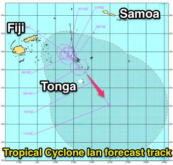
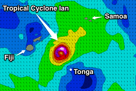
 Tropical Cyclone Ian is currently a category 1 system sitting just west of Fiji.
It initailly developed on January 2nd near Tonga and has meandered about the Lau Basin ever since.
Over the coming days it's expected to intensify while drifting south-east towards and possibly over Tonga.
TC Ian is only expected to reach category 2 status over the coming days and won't generate any swell for the Australian East Coast as it remains too small in scope and is a very large distance from the mainland.
Tonga on the other hand is expected to see large swell from the north and potentially a follow up swell from the south as the system drifts south in close proximity to the Polynesian island. The southern coasts of Fiji will also see medium to large levels of SE swell through this weekend.
Current long-range forecasts have Ian weakening once is drifts south of Tongan latitudes and then swept swiftly away to the east by a frontal system crossing New Zealand.
There's some indication we may see another tropical depression intensifying in the Vanuatu region in the wake of TC Ian. The swell from these developments would make more of an impact across the Australian region, but we'll keep a close eye on this.
Follow the Tongan West Coast forecast here or click the image below for the WAMs.


Comments
Shame about the west wind for ha'atafu. Went there a few years back and there's some super fun waves in the area
Well, there are easterlies forecast for the morning.. albeit 25-30kts!
Sounds like a very handsome cyclone
Ian likely to reach Cat 4 status shortly. Shame he whisks away to the S/SE with no cradling high to his south!!!! :'(
Wow, he is too!
And it's sticking to JWTC's forecasts from Tuesday.
No considerable swell for us, but the tropical developments in the wake of Ian are still positive.
SE Qld is certainly overdue!
Please tell Huey this!!!
Cat 4 this morning.
Such a tiny system! After looking at the North Atlantic for the last few weeks - and the NW Pac before Xmas - it's a little underwhelming on OSCAT.
Still, this system may really create some major problems in Tonga. I hope they're prepared.
Samoa doesn't look like a great place to be right now either.. lashing winds and rain.
Pretty cool earth wind map of Ian.
http://earth.nullschool.net/#current/wind/isobaric/1000hPa/orthographic=...
That's great Don. Wish I paid attention to that map when the 'storm known as Hercules' was doing its business.
Here's Hercules: http://earth.nullschool.net/#2014/01/05/0000Z/wind/isobaric/1000hPa/orth...
You can step back to archive data.
What's even cooler is the upper jet stream: http://earth.nullschool.net/#2014/01/05/0000Z/wind/isobaric/250hPa/ortho...
Well well little old Ian got to Cat 5 last night apparently. Well done old chap.
Wow that is nuts,seeing as early forecasts only had Cat 2.
Underrated.
.....damn handsome too!