Eddie swell looms over Hawaii

This weekend, while most eyes will be on pumping 10 foot Pipeline and the showdown between Mick and Kelly, a much larger swell will be forming in the Western North Pacific Ocean.
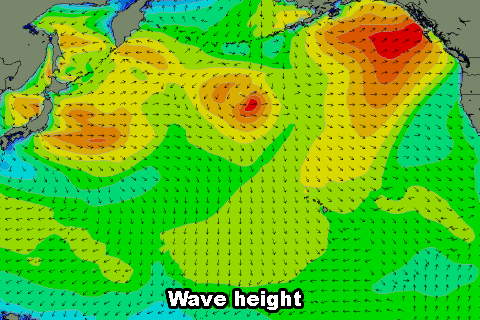
Around the same time the finals are being run, a series of low pressure systems will deepen off Japan, feeding off both a deep pool of cold air in the upper atmosphere and warmer than average sea surface temperatures in the North Pacific.
This mix of extremely cold Siberian air and warm SST's will result in a monstrous storm which will engulf nearly half the North Pacific basin at its strongest point early next week.
The large scope of the system is also likely to be the result of the Fujiwhara Effect, a rare weather phenomena where two lows in close proximity orbit around each other and then combine resulting in the formation of a much larger, all-encompassing storm.
The storm is forecast to aim a large area of 30-45kt W/NW winds towards Hawaii with stronger 50-55kt winds at the core of the system as it creeps closer to the islands.
An extra-large west-northwest groundswell will be generated with an arrival time set down for Thursday next week (Hawaiian time) ahead of a peak Friday morning.
But will it be big enough to run the Eddie Aikau Invitational?
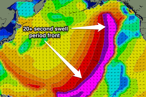
When it comes to Eddie swells, Hawaiian surfers have a rule of thumb: the low pressure system generating the swell should be east of the International Date Line, in to produce the requisite 20+ foot waves at Waimea. And unfortunately this system will fall just short of this, weakening right on the western side of the Date Line.
This isn't to say the swell won't be large, we're expecting 15-20ft waves at the swells peak, but it will be inconsistent due to the extra distance between Hawaii and the storm, so it may just fall below Eddie thresholds.
We'll keep a close eye on the storm as it develops and let you know of any news regarding the possibility of the Eddie running.
Monitor the forecast charts here: North Shore Forecast
Comments
Great article CB. I had no idea the storm had to cross the dateline to meet the contest criteria. No wonder it only runs a coupla times a decade.
The Fujiwhara Effect would be a great name for a band. lol
Could only be a duo.
I can play drums. I bet you can sing, huh?
Yeah that's the general consensus among the event organisers and forecasters, but not a set rule. If the storm is big and strong enough it will override this.
And what a name indeed!
speaking of Physics based names for Bands .
What about " Eddie current suppression Ring " .... yes its real ....
Its actually a smaller iron core that is looped around the primary iron core of a contactor . ( large electrical intiated switch ) ....
Now back to the " other " geek stuff .
This type of swell is good for places further west than Hawaii .
Had two lows back to back do the " Fuji " whilst on a trip a deep in the Pacific a few years back . Did i feel blessed ...
Doing the "Fuji"
... to get down and get nasty.
Really stoked with our model's performance on the North Shore so far this season. It's been accurately picking large groundswells quite some distance in advance, often within just a foot or so of the eventual size. Let's see how this event ends up going down.
Hey Ben, once again congrats on the new forecasting model and tools… there haven't been any decent waves in my neck of the woods for a few weeks but I won't hold that against you guys just yet! At least I can confidently use you reports to not even bother day after day….
Out of interest, have you been cross-checking your forecasting vs Surflines? If so, how do they stack up next to one another?
Thanks Grug. Yeah we've been confirming against all of the other websites wherever possible, and (although biased) we're very confident we have the most accurate forecasting system available.
Actually Ben, thanks to your more detailed report, you guys correctly called a swell in my area that wasn't forecast on my other go to site- Stormsurf. They hadn't registered any waves but you correctly called 2-3ft at south facing beaches and the swell and wind were right on the money. So, good one.
Thanks Zen! That's really useful feedback.
excellent
Unfortunately the storm system isn't forming as favourably as expected with it holding further west and also being positioned a little further south.
This will result in a 'smaller' and more westerly swell, peaking now in the 15-18ft range, under Eddie requirements.
West bowl Sunset!
craig, anything brewing for the eddie ?
As mention just above it looks like the swell will just fall short of the requirements for an Eddie swell with the storm staying a little too west and south.
In saying that the North Shore will still light up with 15-18ft surf!
Latest Oscat data is in and it looks to be slightly higher than modeled wind speeds, so the resulting swell periods should be a little higher than expected, and surf size may also be a little bigger (wouldn't be surprised to see some 20ft+ waves at outer reefs). However it'll probably still fall short of Eddie thresholds at Wiamea and will be extremely inconsistent too.
Yeah agree, outer reefs should see 20ft sets.
Gee P-pass looks the goods on this swell though.
And Allois reckons he only has four people booked in at Pohnpei Surf Club.
not surprised its 4.5k for a return ticket plus excess baggage. Wonder if Martin Daly has any bookings?
Pretty sure you could get it cheaper than that?
is it true $50 or up to $100us per board to get your boards there ?
When I went it was $200 a board! Fortunately I only paid $100 because I had a...ahem, 'journalists pass'.
Ring Continental in advance, tell 'em you're a journo and gonna write nice things about the place you're going and how you got there.
I don't know udo but heard soething along those lines
Stu, guess you would have to get Charlie at perfect wave to get you a ticket. The only ones that come up on dohop and zuji want 9k plus.
http://tinyurl.com/ptbhpqf
I think Intercontinental charge $1000 return from Guam to Pohnpei anyway so getting a cheap return to Guam would be the way to go.
Nah, doesn't matter, Mick. I'm going to Ireland now. Check this for the mother of all swell runs:
https://www.swellnet.com/reports/northern-ireland/county-londonderry/portrush/wams
Don't think I've ever seen an ocean as active.
holy crap! Never seen so many isobars wedged into a map before haha
The draw is up for the Eddie.
http://www.quiksilverlive.com/eddieaikau/2014/blog%2c729%2csurf.en.html
Oh man I just booked Hawaii. Its a shit load warmer than Ireland. Tell Ben you need some alerts set up on the website - I can't check everywhere
When did you book for? I'm going over from 1st to 16th Jan. First time over there so i'm pretty pumped about it!!
P-Pass is going to be off the Richter, can't wait to see the goods from Allois!
And now for an amazing and different view of the storm: http://swllnt.com/1dlK1B7
This is a streamline chart and depicts the flow of the surface wind around the globe at a point in time. Could play with this for hours!
that's unreal what a site
A mutant from P-Pass today taken by Andrew Shield: http://instagram.com/p/iIs4hKTIKl/
Thanks for sharing Craig. That is a fun thing! Zoom-out and you get the Blue Ball view. The Indian Ocean has some special stuff going on at the moment too.
buoy starting to blow up! Super West swell and biggest in Kauai. Be some waves a cooking tomorrow
http://www.surfline.com/buoy-report/nw-hawaii-2_2132_39248/
That earth wind site is sensational, just need to get some time lapse into it now and I would be here for days
http://www.surftagram.com/dave-wassel-202/
Dave Wassel P=pass Coral Head ouch!
Imagine trying to sleep on that thing!
it looks like you can see the tracking running back up through his ribs ... wanna be careful with that .
Well what looked to be a very ordinary season has suddenly turned on with yesterdays 15 foot perfect west swell. There are now 4 more 10 foot plus swells for the next 2 weeks. No Eddie swell there though, but a very active North Pacific.
There's a big wave comp on too @http://asplivescoring.com/puntagaleachallenge/
Waimea has broken in the 18 foot range past two days. Too small for the Eddie but providing some mellow rides and intense shorebreaks. Winds have been sideshore NE
Eddie Swell looms for Friday 17th 5.2m at 16 secs holding all day. Nice shorter period - any thoughts???
Looks like a good system at this stage Mick.. the storm noses quite close to the islands and there's a possibility for a captured fetch too. 5.2m @ 16s isn't quite big enough for the Eddie but it's still a few days out in model land so let's wait and see if it upgrades.
Been keeping a close eye on this storm, but as Ben said, it's not overly strong but does push right down towards Hawaii.
Doesn't look big enough at this stage, and unless the core wind speeds pick up another 10kts it will remain undersized.
Shit its a bit far out but the 22nd is showing 25 foot!!!
That storm for the 22-24th has been upgraded its now 30 -35 feet.....shame about the winds
Models are still struggling to come to grips with the storm firing up next week and will continue to shift around in size. Back to 25ft or so now.
Craig, Im interested to see whether or not you think the NPac jet stream will settle for a few weeks or so in that perfect position of 30 dg N at the dateline? By my reckoning, it could stay put there for a few weeks and encourage the development of a big storm, one each week.
http://www.stormsurfing.com/cgi/display_alt.cgi?a=npac_250
I'll have a deeper look into this when I get a second tonight or maybe tomorrow Rusty.
those winds / swell look a little too west Mick . And die out once they reach the IDL .
Rusty the uppers look promising and produce for the swell next week , and it also looks like a little Fujiwara effect trying to happen but the uppers don't seem to support it long enough ... Interestingly the far forecast has one or two centres of 1040 Highs sitting in the fetch window after that .... long way out all this forecasting for my liking ....
Cheers Southy. I decided a few days ago to pass up this Wednesdays big swell. The winds look to be w- nw- n while the swell peaks. I love kona (s and sw) winds but this storm looks like its right on top of the islands. I think the Bay will he too wobbly to run the Eddie on Thursday. Hence my anticipation of the jet stream locking into its position. Another week or two look the goods.
Yeah winds are terrible for this next swell, as you said storm and associated fronts pushing in too close to the islands.
It's gonna be a biggy though!! Be plenty of options out of the wind.
And after this swell it looks like the jetstream will weaken, with our long-range charts and WAMs failing to pick any major systems, more a large blocking feature in the North Pacific.
ASCAT's looking alright and the WAMS got it above 25ft too...
Yeah it's an absolute beast, been keeping an eye on it, and with those light NW winds during the morning it could of been on... but the window closes tomorrow (Friday 28th), 2 days too early.
Oh well...I guess a lot of crew are over here atm anyway. Well Kelly at least.
Jaws on the other hand, pumping!!!