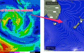
Some powerful but zonal frontal activity will cross the far lower Tasman and send some long period S swell up the Tasman Sea pipe, some of which will wrap into the NSW Coast. Another frontal system then pushes into the Tasman Sea later this week and into the weekend. A typical winter week.
Primary tabs
/reports/forecaster-notes/sydney-hunter-illawarra/2023/07/24/flukey-long-period-s-swells-and
freeride76
Monday, 24 July 2023
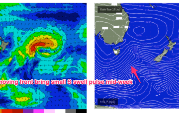
/reports/forecaster-notes/sydney-hunter-illawarra/2023/07/21/active-outlook-sly-winds-will-niggle
freeride76
Friday, 21 July 2023
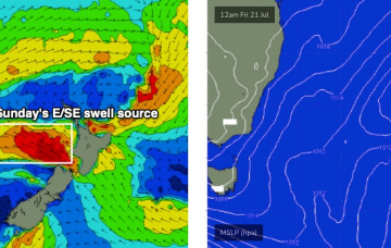
Fridays S’ly change is linked to a robust front (and long angular trough of low pressure in the Tasman) and the northwards intrusion into the Tasman will bring plenty of directional S swell- up into the 4-5ft range at S facing beaches, bigger 6ft at least, on the Hunter
/reports/forecaster-notes/sydney-hunter-illawarra/2023/07/19/multiple-strong-swells-the-south-and
thermalben
Wednesday, 19 July 2023
Looks like we’ve got an upgrade in store for Thursday’s size.
/reports/forecaster-notes/sydney-hunter-illawarra/2023/07/17/more-active-period-ahead-low-pressure-0
freeride76
Monday, 17 July 2023
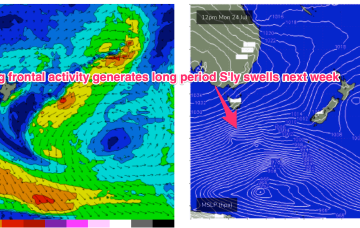
We’ve got a mobile pattern this week with high pressure over NSW slipping out into the Tasman, before a trough and front push into the Tasman in advance of another high cell moving over Southern NSW into the Tasman. We’ll see quite a few wind changes this week as a result and modest upgrade in S swell energy as the trough and front develop a handy fetch in the Tasman

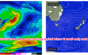
/reports/forecaster-notes/sydney-hunter-illawarra/2023/07/14/tiny-weekend-another-week-minor-s-swell
freeride76
Friday, 14 July 2023
Blocking high pressure in the Central Tasman has a ridge up the QLD Coast, with weak pressure gradients across NSW leading to pre-frontal N-NW winds. Not much surf on offer either day.
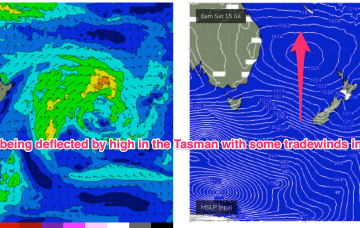
/reports/forecaster-notes/sydney-hunter-illawarra/2023/07/11/small-s-pulses-dry-over-the-weekend
freeride76
Wednesday, 12 July 2023
Cold fronts have passed through the Tasman and the high pressure will now exert a blocking effect, steering fronts well away from the swell window or ensuring a zonal (W-E) flow through the end of the week and into the weekend.
/reports/forecaster-notes/sydney-hunter-illawarra/2023/07/10/quiet-period-continues-just-small-s
freeride76
Monday, 10 July 2023
Another week begins with a classic winter El Niño pattern. High pressure over the continent with a W’ly flow being enhanced by a series of mobile fronts and parent lows, sending small S swell pulses our way.

/reports/forecaster-notes/sydney-hunter-illawarra/2023/07/07/small-and-offshore-the-weekend-s-swell
freeride76
Friday, 7 July 2023
We’re still on track for basically offshore winds all weekend as high pressure to the north and a series of fronts to the south bring the W’ly belt across the Southern half of the maritime continent.
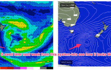
/reports/forecaster-notes/sydney-hunter-illawarra/2023/07/05/more-sse-swell-come-typical-winter
freeride76
Wednesday, 5 July 2023
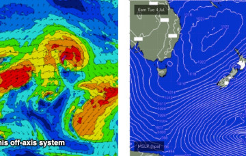
A more typical winter pattern which we saw in June is set to return, with high pressure over the continent ridging against frontal activity with a W’ly flow extending right up to the sub-tropics. Residual S/SE groundswell pulses from the off axis fetch as it drifted slowly SE of the South Island will put a floor under wave heights before we see a fresh round of S swell early next week.
/reports/forecaster-notes/sydney-hunter-illawarra/2023/07/03/continue-your-focus-the-south
thermalben
Monday, 3 July 2023
The Long Wave Trough responsible for our current southerly swell regime is exiting New Zealand longitudes, though we’re still seeing strong polar activity off the ice shelf.