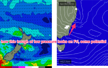
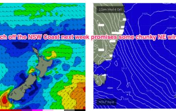
Moderate strength high pressure (1025 hPa) is drifting NE into the Tasman with a strong polar storm well SW of NZ exiting the swell window. That should see a settled short term before another complex trough and frontal system pushes north along the coast tomorrow with a stiff SW-S change. N'ly winds into the weekend under a very mobile, troughy pattern with some potential next week for a surface low to form in one of the trough lines.
Primary tabs
/reports/forecaster-notes/south-east-queensland-northern-new-south-wales/2023/10/11/october-nlies-the
freeride76
Wednesday, 11 October 2023
/reports/forecaster-notes/south-east-queensland-northern-new-south-wales/2023/10/09/patchwork-quilt
thermalben
Monday, 9 October 2023
I’m not super confident on the weekend outlook.
/reports/forecaster-notes/south-east-queensland-northern-new-south-wales/2023/10/06/punchy-windy
thermalben
Friday, 6 October 2023
We've got more southerly swell on the way.
/reports/forecaster-notes/south-east-queensland-northern-new-south-wales/2023/10/04/solid-though
thermalben
Wednesday, 4 October 2023
We've had a slight tweak to the surf outlook for Thursday, mainly for SE Qld.
/reports/forecaster-notes/south-east-queensland-northern-new-south-wales/2023/10/02/punchy-and-windy
thermalben
Monday, 2 October 2023
It's one of the strongest N'ly local fetches we've seen in a while and will consequently deliver a punchy, sizeable NE windswell during the middle of the week.
/reports/forecaster-notes/south-east-queensland-northern-new-south-wales/2023/09/29/plenty-nlies-some
freeride76
Friday, 29 September 2023
We’ve got a strong, expansive front passing through the Tasman at present will which supply some small pulses of S swell over the coming days. High pressure over NSW is moving NE into the Tasman, with a N’ly flow presently developing.

/reports/forecaster-notes/south-east-queensland-northern-new-south-wales/2023/09/27/few-small-options
freeride76
Wednesday, 27 September 2023
High cells are now tending to move NE as they enter the Tasman, bringing N’ly episodes which were rare through our triple La Niña but are becoming common as we enter El Niño proper. Small, combination swells and some light wind periods pad out the rest of the week with a more entrenched N’ly episode next week.
/reports/forecaster-notes/south-east-queensland-northern-new-south-wales/2023/09/25/fun-options
freeride76
Monday, 25 September 2023
The high pressure belt is behaving in typical spring fashion- tracking NE as it enters the Tasman with episodic N’lies. We’ve got a small fetch out of Cook Strait at present from a decaying low pressure system, and small, compact low about to enter the Tasman. Combined with some swell from a tradewind band feeding into a long trough we’ll see concurrent small swells from these sources.

/reports/forecaster-notes/south-east-queensland-northern-new-south-wales/2023/09/22/small-peelers
freeride76
Friday, 22 September 2023
A tradewind band thickens up in the South Pacific over the weekend and tilts more E/NE as winds feed into a long trough. That should see E'ly swell bump up a notch into Tues and Wed.

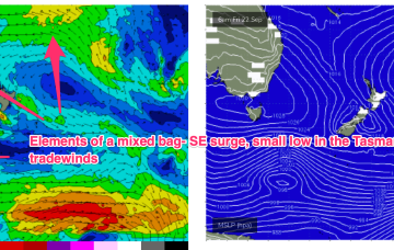
/reports/forecaster-notes/south-east-queensland-northern-new-south-wales/2023/09/20/strong-se-surge
Strong SE surge brings plenty of short range swell with E'ly tradewind swell continuing to chug away
freeride76
Wednesday, 20 September 2023
High pressure is now close to New Zealand, with an advancing trough and cold front bringing a fresh S’ly change, expected to generate a strong SE surge up the sub-tropical coast as a new high moves into the Bight and strengthens. Once the new high high moves into the Tasman over the weekend it’ll set up a blocking pattern but we’re expecting a few small S pulses leading up to that although winds look fickle. E’ly trade-wind swells continue at small levels into the short/medium term.