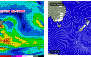
Fun tomorrow, with a window early next week
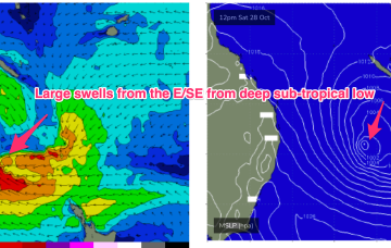
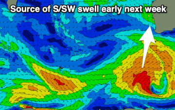
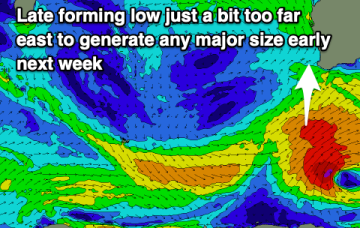
Make the most of the coming windows of swell and winds as the outlook otherwise remains average.
The evolution of the surface low in the sub-tropics is complicated and running a little behind schedule, but as we suggested on Wed we’ll see the remnants of severe TC Lola drift into and become absorbed into the large low centre over the weekend as it approaches the North Island.
We’ve still got the building blocks in place for large swells across most of the Eastern Seaboard, with a large high , powerful frontal system, and deepening trough (still expected to form a surface low) in the Northern Tasman currently in play.
We'll see clean conditions tomorrow morning with smaller, easing surf down South. A large swell is due next Tuesday, best in the gulf wind wise.
Hit the exposed beaches tomorrow and then work around a larger swell due next week.
Small swells persist, best on the magnets. SE trade-swell kicks back in across the Maldives.
The outlook is very active with plenty of opportunities for a surf.
Spectacular charts more characteristic of late Summer/Autumn with a Cat 5 TC in the South Pacific bearing down on Vanuatu, and a powerful frontal intrusion poised to enter the Tasman Sea backed by a monster high in the Bight.
Spectacular charts more characteristic of late Summer/Autumn with a Cat 5 TC in the South Pacific bearing down on Vanuatu, and a powerful frontal intrusion poised to enter the Tasman Sea backed by a monster high in the Bight. A strong S-SE surge associated with this system spawns a surface low off the North Coast when it encounters a trough line in that zone.
The coming days will see weak levels of swell building, biggest Saturday as winds shift offshore. A more south swell with a bit more size is due Monday.