Fading surf on the weekend, large into next week

South Australian Surf Forecast by Craig Brokensha (issued Friday October 27th)
Best Days: South Coast tomorrow morning, Mid Coast Tuesday, Mid Coast Wednesday
Features of the Forecast (tl;dr)
- Easing S swell Sat with freshening N/NE tending N/NW winds ahead of a PM SW-S/SW change
- Tiny W/SW swell for Sat PM
- Small-mod sized W/SW swell building Sun. easing Mon
- Light, local offshore winds Sun AM, strengthening from the SW-W/SW into the PM
- Strengthening W/NW winds Mon with a building windswell
- Large SW groundsswell building Tue, peaking into the PM with strong but easing S/SW winds
- Easing swell Wed with SE tending S/SW winds
Recap
The South Coast remained poor and onshore yesterday with plenty of size white the Mid Coast eased back to 1-1.5ft with nice clean conditions and novelty waves on the reefs. Today the swell is still up to 3-4ft on the South Coast thanks to a reinforcing mid-period S’ly swell though conditions are lumpy thanks to yesterday’s onshore winds. The Mid Coast is clean but tiny.
This weekend and next week (Oct 28 - Nov 3)
The reinforcing pulse of S’ly swell seen today, generated by the polar front to our south, will ease off through tomorrow with the morning being the pick of the weekend for the South Coast.
Easing 2ft to possibly 3ft sets are due across Middleton, down to 1-2ft into the afternoon.
Winds will freshen from the N/NE tending N/NW ahead of a gusty SW-S/SW change into the afternoon.
This will be related to a weak mid-latitude front passing below us, with winds due to shift back to the N/NE but with a low point in swell.
On the Mid Coast, the weak front will generate a small to moderate sized pulse of W/SW swell for the afternoon, pulsing to 2ft on the sets with the favourable parts of the tide but with strengthening SW-W/SW winds
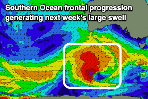
This will be as the next swell generating system pushes up and into the state, that being a broad, strong Southern Ocean frontal progression, with it forming to the south-southwest of Western Australia tomorrow.
This progression is now looking quite healthy with a fetch of gale to severe-gale W/SW-SW winds moving through our south-western swell window, with a little sling-shot push helping to produce a large SW groundswell for Tuesday, peaking into the afternoon.
Middleton should build to a strong 6ft+ with 8ft sets likely on the deepwater reefs while the Mid Coast should come in at 2ft to occasionally 3ft.
Unfortunately winds look poor for the South Coast, strong from the S/SW though easing through the day, with the Mid performing better under S/SW winds that may tend S/SE at dawn.
Wednesday looks nice and clean with easing surf under a SE offshore in the gulf, while the South Coast looks to remain bumpy and lumpy with an E/SE breeze.
Later week it looks like a high will bring S/SE winds, spoiling some good reinforcing S/SW groundswell, but more on this Monday. Have a great weekend!