Weak swells for the coming days, fun Saturday

Western Australian Surf Forecast by Craig Brokensha (issued Wednesday October 25th)
Best Days: Saturday morning Margs and Mandurah, Monday morning Margs and Mandurah, Tuesday morning Margs and Mandurah, Wednesday morning in the South West
Features of the Forecast (tl;dr)
- SW winds tomorrow, strengthening through the afternoon with a small, building W/SW swell, peaking Fri AM
- Fresh S/SE winds Fri AM, strengthening into the PM from the S'th
- Moderate sized mid-period SW swell for Sat, easing through the day
- E/SE winds ahead of late morning sea breezes
- Easing surf Sun with SW winds (SE early Perth and Mandurah)
- Moderate + sized S/SW swell Mon, peaking into the PM with fresh SE tending strong S/SE winds (S/SW to the north)
- Easing surf Tue with fresh E/SE-SE tending S/SW winds
- Smaller Wed with E tending S/SW winds
Recap
A fun lift in small swell yesterday morning to 3-5ft across the South West and 1-1.5ft to the north under gusty offshore morning winds. Winds tended more NE into the afternoon keeping conditions relatively clean as the swell eased.
Today there's nothing left in the tank and strong offshore winds have blown out the surf in the South West.
This week and next (Oct 26 – Nov 3)
Over the coming days small pulses of weak W/SW swell, generated by a weak frontal progression moving in from west yesterday, through today and then moving further off to the east tomorrow.

The first front dipped quickly to the south-east and this will generate tomorrow's building swell that's due to peak early Friday with a kick to 3-4ft due across the South West magnets, tiny and to 1-1.5ft to the north.
Winds tomorrow look average as today's strengthening east-northeast winds feed into a trough that will bring a shallow SW change. Strengthening S/SW winds will develop into the afternoon, with Friday seeing fresh S/SE winds, strengthening from the S'th into the afternoon.
The slower moving front that's currently south-west of us should generate a slightly better (size wise) pulse of mid-period SW swell Saturday, coming in at 4-6ft across the South West while Mandurah and Perth look to come in at 1-2ft and 1-1.5ft respectively.
Winds look great on Saturday morning with a light E/SE, offshore wind though sea breezes will kick in late morning. Make the most of it as a trough will bring a SW change on Sunday (SE early across Perth and Mandurah) though with tiny surf.
Into next week the only really noticeable pulse of swell is due into Monday, generated by a healthy, strong but late forming Southern Ocean frontal system, south-west of us Friday evening.
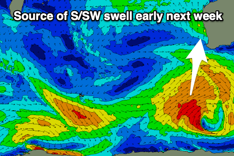
A fetch of strong to gale-force W/SW-SW winds should generate a moderate sized + S/SW swell for Monday, peaking through the afternoon to the 6ft range across the magnets, 1-2ft in Mandurah and tiny across Perth.
Winds look fresh SE on Monday morning, strengthening from the S/SE into the afternoon across the South West (S/SW to the north), with Tuesday seeing better E/SE-SE offshores as the swell eases from the south.
Wednesday looks smaller with E-E/NE winds and for the rest of the week there's nothing too significant on the cards, similar into the following week. Therefore make the most of the small windows of waves during the coming period.