Coupla strong swells on the boil; one with good winds, one without

Western Australian Forecast by Ben Matson (issued Wednesday November 27th)
Features of the Forecast (tl;dr)
- Powerful groundswell Thursday with generally offshore winds
- Size easing Friday with early light winds
- Average weekend, Saturday looking best but winds will cause some issues (mainly Sunday)
- Very large windy swell early next week
- Small spell of surf expoected later next week and weekend
Recap
Tiny surf on the metro beaches with small waves across the Margs region, wind affected on Tuesday but clean this morning with light offshore winds.
This week (Nov 28 - 29)
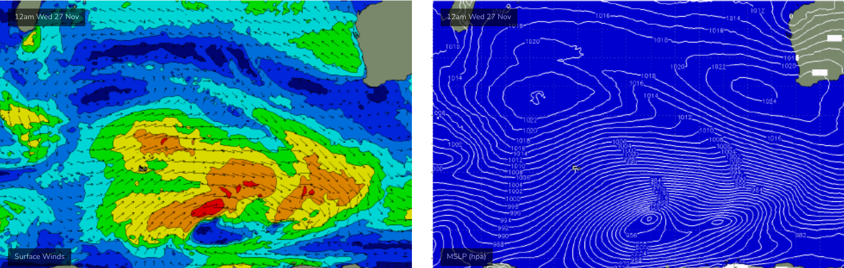
A new long period swell is expected to push into the region overnight and build towards a mid-late morning peak.
As mentioned on Monday, the wave models are undercooking this swell but with leading edge swell periods expected to be in the 18-19 second range and the peak of the swell likely to hover around 15-16 seconds, it’s going to be a strong swell event - with long breaks between sets but great waves across all coasts with early light offshore winds.
Surf size should nudge the 8-10ft+ range across exposed Margs reefs, and metro beaches should see good surf in the 2-3ft range.
Easing surf is then expected into Friday with early light offshore winds keeping conditions nice and clean. Size should manage 4-6ft at exposed Margs breaks with smaller 2ft surf across metro beaches, easing through the day.
This weekend (Nov 30 - Dec 1)
A small lift in new swell is expected on Saturday, originating from another strong though somewhat distant polar low that's powering through the Southern Indian Ocean this week. Additionally, there is a secondary swell source to the north - a cold front that's split from the primary system (see below).
This disjointed fetch will lower size potential, though the models are again undercooking surf size so we'll have to keep a watch on the trends over the coming days.
Local winds are expected to be onshore though only light in strength on Saturday, so conditions should be reasonably good. Sunday is at risk of freshening W/NW winds as another strong front and low rears up from the SW, so at this stage aim for Saturday if you only have weekend surfing options.
Surf size should build from 3-5ft back up into the 5-6ft range across the Margs region (Saturday), easing from a similar size on Sunday. Sets should push 2ft across metro beaches.
Let’s fine tune things on Friday.
Next week (Dec 2 onwards)
Model guidance has slightly eased the strength of the frontal passage due Monday though a secondary front will approach the coast on Tuesday so we’ll be under a sustained onshore pattern from Monday thru’ Wednesday.
As for size, Monday’s looking very big, probably around 10-12ft but too wind affected to offer anything worthwhil at exposed spots across the Margs region. I am also a little concerned that the approaching secondary front may steer the wind around the W, maybe even W/NW, which may cause problems across the protected bays and points.
Winds won’t be quite as strong across metro beaches where we should see surf size around the 3ft mark (bigger in Mandurah).
We’ll see an easing trend through Tuesday and Wednesday - though still solid, onshore surf across the region - before a prolonged period of smaller surf with seasonal S/SE winds settles across the region.
So, make the most of the upcoming swells as it’s expected to go a little quiet after this.