Average weekend, windier but better next week

Western Australian Surf Forecast by Craig Brokensha (issued Friday March 15th)
Best Days: Protected spots Monday and Tuesday morning in the South West, next Friday
Features of the Forecast (tl;dr)
- Small, inconsistent mid-period W/SW swell building Sat with fresh E/NE winds ahead of sea breezes
- Moderate sized, inconsistent mid-period W/SW swell building Sun with early light S/SE winds, tending SW-S/SW through the day and strengthening
- Strong S/SE winds Mon (S/SW to the north in the PM), with a large, building SW-S/SW groundswell
- Easing S/SW groundswell Tue with strong SE-E/SE tending S/SE winds
- Small Wed with strong E winds
- Mod-large, inconsistent SW groundswell for later Thu, peaking Fri with strong E/SE winds
Recap
Easing surf the past two days, small and clean in the South West yesterday, back to 2ft or so today while Perth and Mandurah have been tiny.
This weekend and next week (Mar 16 - 22)
As touched on earlier in the week, the surf should start to build slowly through the weekend again, peaking on Sunday afternoon but with less than ideal winds.
Tomorrow's increase will be small and slow, reaching 3ft into the afternoon across the South West, when sea breezes kick in (fresh, morning E/NE winds).
Sunday's looks better with 4-5ft+ sets due (tiny to the north) but winds will shift S/SW through the morning (likely S/SE early) and strengthen from the S/SW-SW into the afternoon as the swell builds.
This shift in winds will be thanks to the next swell generating system clipping the state, with it producing a large SW-S/SW groundswell for Monday afternoon.
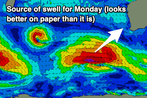
The low generating this swell is a little disjointed, but strong, with patchy fetches of severe-gale W/NW winds due to reach near storm-force at its core while tracking east.
The swell should reach 6-8ft across the South West into the afternoon, 2ft in Mandurah and 1-2ft in Perth. Tuesday will become smaller quickly with easing 5ft sets across the South West, tiny to the north.
Now, local winds on Monday will shift back to the S/SE and be strong (tending S/SW to the north into the afternoon), swinging more SE to possibly E/SE Tuesday morning but remaining strong. With this protected spots will fair best.
Winds should go more E'ly on Wednesday but the swell will be much smaller and fading from 2-3ft max.
The next noticeable increase in swell is due Friday, that being an inconsistent, long-period SW groundswell from a strong polar low forming west of the Heard Island region this weekend. The low will be strong but a little distant from us, with swell decay being the main issue. A small fetch of severe-gale winds will then weaken but persist as the low moves slowly east into early next week. This will prolong the swell, with it due to arrive later Thursday but peak Friday to the 6ft range in the South West, 1-1.5ft to the north. Saturday should still be 4-6ft but easing.
Winds at this stage could be gusty E/SE Friday morning but we'll have a closer look at this Monday. Have a great weekend!