A couple of fun mornings this week

Western Australian Surf Forecast by Craig Brokensha (issued Monday February 12th)
Best Days: Wednesday morning in the South West, Thursday morning in the South West
Features of the Forecast (tl;dr)
- Late pulse of moderate sized, mid-period S/SW swell tomorrow with gusty S/SE-SE winds, strengthening from the S'th
- Peak in swell Wed AM with mod-fresh E/SE tending strong S winds
- Easing swell Thu with E/SE-SE tending strong S winds
- Moderate sized S/SW groundswell building Fri, peaking into the PM with strong S/SE-S winds
- Easing swell Sat with S/SE winds
Recap
Small, clean 2-3ft surf in the South West Saturday morning but the rest of the weekend as average with smaller surf yesterday and no options in Perth/Mandurah.
Today is windier and choppy with a little pulse of new swell.
This week and weekend (Feb 13 - 19)
It can only get better from here with some fun swell on the way with offshore winds as it peaks on early Wednesday morning.
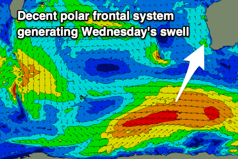
The source was a broad fetch of strong W/SW winds to our south-west yesterday, with a moderate sized pulse of S/SW swell due to arrive later tomorrow but peak early Wednesday morning to a good 4-6ft across the South West, 1-1.5ft in Mandurah and Perth.
Winds tomorrow as mid-period swell builds look average with gusty S/SE-SE breezes due, strengthening into the afternoon, with Wednesday morning looking the pick under a moderate to fresh E/SE offshore.
Thursday will also be fun though smaller and easing back from 3-4ft on the South West magnets with E/SE-SE morning winds.

Into the end of the week, a new pulse of S/SW groundswell is due, generated by a strong but short-lived polar low firing up around the Heard Island region today. A fetch of severe-gale to storm-force winds should produce a fleeting pulse of energy for Friday, building to 4-6ft into the afternoon but with strong S/SE tending S winds (tiny to the north)
Similar, gusty S/SE winds are due into Saturday but with a rapidly easing swell back from the 3-4ft range.
Following this, the outlook is slow with smaller, mid-period swells on the cards for early next week and beyond. There is the chance for a bigger swell mid-week but it'll be low quality, localised windswell. More on this in Wednesday's update.