Good surf this morning and later week

Western Australian Surf Forecast by Craig Brokensha (issued Monday December 25th)
Best Days: This morning in the South West and Mandurah, Friday morning in the South West, Saturday morning for the keen in the South West
Features of the Forecast (tl;dr)
- Fresh S/SW tending SW winds Tue, strong S/SE Wed
- Small, background mid-period swell Thu with strong SE winds ahead of strong sea breezes
- Moderate sized, inconsistent SW groundswell building Fri, mixed in with mid-period S/SW energy
- Gusty E/SE winds Fri AM ahead of strong sea breezes
- Easing swell Sat with SE tending S/SW winds
Recap
Merry Christmas!
The weekend started slow with nothing of note on Saturday, but our new, building mix of SW swells for yesterday came in nicely across the South West with strong but easing offshore winds and increasing size. The mid-late morning offered the best surf with inconsistent sets pushing to 5-6ft. Mandurah was tiny though built to 1-2ft through the day, best late morning ahead of sea breezes. Perth remained tiny.
This morning is still clean and good across the South West though make the most of it as the rest of the outlook looks slower.

Great conditions with the building swell yesterday
This week and weekend (Dec 26 - 31)
Our current swell will back off over the coming days and conditions will deteriorate as winds go onshore thanks to a trough moving in from the west, bringing cooler conditions and S/SW winds across the South West tomorrow SW to the north.
A new ridge of high pressure is then expected to shift in from the west on Wednesday, swinging winds to the S/SE though strong in the South West. This will be along with some weak, localised mid-period S/SW swell to no real size.
Later in the week winds should slowly swing more offshore, with a strong SE breeze due Thursday morning, and then E/SE on Friday morning.
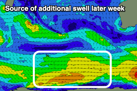
As touched on in last week’s update, some inconsistent, long-period SW groundswell is due, mixed in with mid-period S/SW swell in the mix.
The long-range energy was generated south of South Africa, in our far swell window, with the mid-period energy generated by weaker but broad polar frontal activity, south-west of the state.
Building surf is due on Thursday with Friday afternoon offering the peak in size from both sources, coming in at a slow 4-5ft across the South West (rare bigger one), tiny to the north, then easing from 4ft+ on Saturday morning.
Winds look to shift SE on Saturday morning with S/SE-SE winds due to follow Sunday and into early in the New Year along with no major swells. Therefore make the most of this morning and Friday morning. Have a great Christmas!