Tricky week though with waves across the metro beaches

Western Australian Surf Forecast by Craig Brokensha (issued Monday November 27th)
Best Days: Early tomorrow Perth and Mandurah for the keen, similar Wednesday morning, Thursday morning for the keen Perth and Mandurah, Friday morning in the South West
Features of the Forecast (tl;dr)
- Small, inconsistent SW swell building tomorrow, peaking Wed
- Small, fun W/SW windswell building tomorrow, peaking Wed, easing Thu
- Increasing W/NW-NW winds tomorrow (likely variable early Perth and Mandurah)
- Variable winds Wed AM, shifting S/SW-SW through the morning and freshening
- Temp, low point in swell Thu AM, with an small pulse of mid-period SW swell for the PM, easing Fri
- S/SE tending S/SW winds Thu, gusty E/SE tending S/SW winds Fri
- Increasing W winds on the weekend
- Mod-large mid-period W/SW swell for Mon, with a larger SW swell for Tue
Recap
Small to tiny surf was seen on the weekend across the South West with strong morning offshore winds, tiny today as winds start to shift W/NW-NW.
This week and weekend (Nov 28 – Dec 3)
The stalling heat trough/low to the west of the state during last week, drawing in record breaking temperatures from inland is now starting to move south-east across us.
This is bringing the shift in winds today and tomorrow, spoiling a small, inconsistent mid-period SW swell that's due to build through the day, peaking Wednesday.
There's a chance for more variable winds across both coasts tomorrow and Wednesday mornings but the waves will be lumpy.
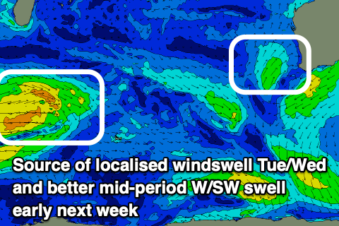
The metro locations should see some fun, weak W/SW windswell generated on the northern side of the heat-low, with persistent W/SW winds today, tomorrow and Wednesday likely to generate 2ft to occasionally 3ft sets in Perth and Mandurah (peaking Wednesday), with the South West coming in at 4ft.
A temporary low point in swell is due on Thursday morning ahead of another small pulse of mid-period SW swell into the afternoon, generated by background frontal activity through the Southern Ocean.
No major size over 4ft is due in the South West, tiny across Perth and Mandurah, though the windswell looks to be easing from 2ft in the morning on Thursday.
Winds will improve a touch, shifting S/SE through the morning ahead of sea breezes, great Friday morning and E/SE but with small, fading surf.
Moving into the weekend winds will shift back to the W/SW on Saturday, strengthening Sunday thanks to a broad, slow moving mid-latitude low moving in from the west.
This low will finally bring some better sized swell to the state next week, though with what looks to be average winds (for the South West). I guess beggars can't be choosers!
The low will develop south-east of Madagascar tomorrow, moving slowly east while generating a fetch of strong to sub-gale-force W/SW winds through our western swell window. As the low nears closer we may see it strengthen, generating additional gales but we'll confirm this on Wednesday.
Regardless, a moderate-large mid-period W/SW swell will be generated by the initial stages of the low for Monday, with a larger pulse due from the secondary developments Tuesday.
At this stage local winds on Monday look onshore for the South West, cleaner in Perth and Mandurah with good sized sets, similar Tuesday. We'll have a closer look at the sizes and winds on Wednesday.