Weak swells for the period with funky winds

Western Australian Surf Forecast by Craig Brokensha (issued Wednesday October 18th)
Best Days: Tomorrow ahead of sea breezes in the South West and Mandurah, Friday morning in the South West and Mandurah, Tuesday morning in the South West, late next week
Features of the Forecast (tl;dr)
- Moderate sized, mid-period SW swell building tomorrow with morning E/SE winds ahead of sea breezes (SE to the north)
- Easing swell Fri with E winds ahead of sea breezes
- Smaller Sat with freshening E/NE tending NE winds, tending NW
- Strengthening W/SW winds Sun
- Weak S'ly swell building Mon with strong S/SW winds
- Small to moderate sized, mid-period SW swell for Tue AM with easing S swell. E'ly winds ahead of sea breezes
- Fading surf Wed and Thu with morning offshore winds
- Possible large W/SW groundswell next Fri
Recap
Light winds created clean conditions across all locations yesterday morning but the swell faded back to the small to tiny range, bottoming out today with onshore winds in the South West, cleaner to the north with a weak windswell.
This week and next (Oct 19 - 27)
Our small pulse of mid-period SW swell for tomorrow is still on track, generated by a weak front that's been moving through our swell window, west-southwest of the state the last two days.
No major size is expected but we should see the South West building to 4-5ft+ tomorrow afternoon, 1-2ft across Mandurah and 1-1.5ft in Perth.
Conditions will be good in the morning with an E/SE offshore across the South West, more SE to the north, ahead of afternoon sea breezes.
Friday should be nice and clean again but with easing surf, down on tomorrow afternoon's size in the South West, likely still 1-2ft at dawn in Mandurah and 1-1.5ft across Perth. Get in through the morning before sea breezes kick in again after lunch.
Freshening, offshore E/NE tending NE winds are due into Saturday but with small, fading surf, while a trough will see winds shift NW into the afternoon and then strengthen from the W/SW on Sunday as the trough forms into a low, south of us.

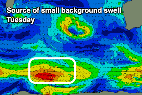
A small, weak mid-period S'ly swell is due to be generated on the western flank of the low for Monday to 4ft max but with strong S/SW winds. E'ly offshore winds are then due into Tuesday as the low moves east as the S swell fades. A small, background mid-period SW swell should offer 4-5ft sets in the morning, easing through the day and then smaller Wednesday, tiny Thursday.
Both these days will see offshore winds with building heat but no meaningful surf.
Longer term a more significant storm may develop in the Heard Island region early next week, generating a large W/SW groundswell for late next week but we'll have a closer look at this on Friday.