Windy weekend with some sizey surf

Western Australia Surf Forecast by Craig Brokensha (issued Friday December 30th)
Best Days: Protected spots on the weekend, Monday morning, Tuesday morning, Wednesday morning in the South West
Features of the Forecast (tl;dr)
- Building S/SW groundswell Fri with gusty S/SE winds, shifting S/SW-SW winds
- Better moderate-large sized SW swell building Sat, peaking late in the day/Sun AM, with a secondary slightly smaller pulse Sun PM, peaking Mon AM
- Gusty S-S/SE tending S/SW-SW winds on Sat, fresh S/SE tending strong S/SE winds Sun (S/SW to the north)
- Slow easing surf Mon PM with gusty SE tending strong S/SE winds
- Final pulse of moderate sized + mid-period S/SW swell Tue AM with gusty SE tending S/SE winds, easing Wed with E/SE tending S/SE winds
Recap
Really fun surf yesterday morning with clean conditions across all locations but a drop in size back to 4-5ft in the South West with tiny 1-1.5ft waves in Mandurah and Perth.
Today the swell is smaller and weaker with less favourable winds. An inconsistent S/SW groundswell is due across the South West but with deteriorating winds.
This weekend and next week (Dec 31 - Jan 6)
The weekend looks better for swell, though local winds will limit the best waves to protected spots, which will be smaller than the locations seeing all the size.
During tomorrow we should see a moderate-large pulse of mid-period SW swell filling in, peaking into the evening but remaining solid into Sunday morning ahead of a reinforcing pulse of energy through Sunday afternoon and Monday morning.
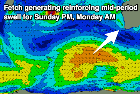
These swells have been generated by a healthy polar frontal progression firing up between us and the Heard Island region, with an initial front producing a healthy and broad fetch of strong to at times gale-force W/SW winds, followed by a secondary system that's now projecting north-east towards us, on the tail of the progression.
Building surf to 6-8ft is expected tomorrow afternoon/evening across the South West, easing from a similar size Sunday morning, with the reinforcing swell maintaining 6ft surf into the afternoon/evening, easing from a similar size Monday afternoon.
Mandurah looks to come in at 2-3ft on the first pulse and 2ft+ on the second with 2ft and 1-2ft sets respectively across Perth during each pulse.
Now, winds will be gusty from the S/SE-S tomorrow morning, shifting S/SW-SW into the afternoon creating generally poor conditions, weaker Sunday morning but still S/SE and fresh through the morning. Strengthening S/SE winds are due into the afternoon in the South West, S/SW to the north while Monday should see gusty morning SE winds, opening up a few more options.
One final front projecting towards us on the weekend will generate a final pulse of reinforcing mid-period S/SW swell for Monday afternoon and Tuesday morning, slowing the easing trend.

We should still see 4-6ft sets in the South West Tuesday morning with 2ft sets across Mandurah and fading 1-2ft waves in Perth.
Winds look strong from the SE through the morning again, with Wednesday seeing a touch more E/SE winds as the swell becomes smaller.
Longer term there's nothing too significant on the cards but the models diverge a little so check back here next week for the latest. Have a great weekend and Happy New Year!