Strong, powerful swell for Sunday

Western Australian Surf Forecast by Craig Brokensha (issued Friday December 23rd)
Best Days: Sunday in the South West for the experienced, early Monday all locations, Wednesday morning all locations, Thursday morning in the South West
Features of the Forecast (tl;dr)
- Oversized SW groundswell building rapidly Sun with mod-fresh SE tending strong S/SW-SW winds (S/SE into the evening in the South West)
- Large, easing SW groundswell Mon with early S/SE tending S/SW-SW winds mid-AM
- Building reinforcing mid-period SW swell Tue with SW winds
- Easing mid-period SW swell Wed with E/SE tending S/SW winds, smaller Thu with similar winds
Recap
Pumping surf in the South West yesterday with clean conditions and sets to 6-8ft in the South West, 2ft+ across Mandurah and 1-2ft in Perth with morning offshore winds.
Today the swell has eased a little and with less favourable though still decent winds in the South West, back to 5-6ft with clean 2ft sets across Mandurah and 1-2ft waves hanging in across Perth. Get out there before sea breezes kick in.

Solid, clean surf yesterday AM
This weekend and next week (Dec 24 - 30)
The surf will become smaller into tomorrow morning and winds look S/SE, less than ideal and only for the keen in the South West.
Christmas Day on the other hand will be in stark contrast. We’re set to see an oversized, long-period SW groundswell building rapidly across the South West, more so through the afternoon to the north.
This swell is thanks to a ‘bombing’ low forming east of the Heard Island today.
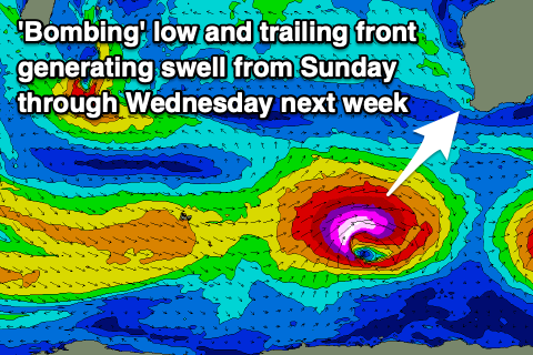
The catalyst for the ‘bombing’ low was a tropical depression being dragged south-east, into the westerly storm track from between Madagascar and South Africa. It’s dropping more than 24hPa within a 24 hour period and we’re seeing a great storm-force fetch of W/SW-W winds being projected east.
The low will maintain its strength into this evening before slowly weakening tomorrow, pushing out of our swell window.
The significant fetch strength, and rapid intensification should produce an oversized, long-period SW groundswell that will arrive mid-morning in the South West and build rapidly with step-ladder sets. That being increasing size, set on set.
We should see the exposed reefs reaching 12ft+ with 15ft’ers on the deep water reefs into the afternoon, while Mandurah should build to 4ft later with 3ft waves across Perth. Winds look favourable in the morning and moderate to fresh from the SE, though strong S/SW sea breezes will kick in late morning in the South West, SW to the north, spoiling the swell. Expect winds to go back S/SE into the evening in the South West as the swell peaks.
Monday morning should still be large but easing fairly steadily thanks to the low forming rather late in our swell window. Easing sets from 10-12ft are due Monday morning in the South West, 3-4ft across Mandurah and 2-3ft in Perth with early S/SE winds, quickly deteriorating and shifting S/SW-SW mid-morning.
This will be linked to a trailing front on the back of the ‘bombing’ low projecting up and clipping us. The front will actually strengthen, leaving SW winds into Tuesday as a good reinforcing pulse of mid-period SW swell fills in, peaking Wednesday morning.
The size looks to see waves holding 6ft across the South West, 2ft Mandurah and 1-2ft in Perth through Tuesday afternoon and Wednesday morning with a rapid improvement in winds. A high will quickly slide in, swinging winds around to the E/SE through the morning Wednesday, giving into afternoon sea breezes.
Longer term the swell will continue to ease into the end of the week with favourable winds Thursday, less so Friday. A decent sized mid-period SW swell but with S/SE winds is possible next weekend, but we’ll review this Monday. Have a great weekend and Merry Christamas!