Good surf tomorrow, tricky weekend

Western Australia Surf Forecast by Craig Brokensha (issued Wednesday November 2nd)
Best Days: Tomorrow, protected spots Saturday, Sunday morning in the South West, Tuesday morning
Features of the Forecast (tl;dr)
- Mod-large SW groundswell arriving later today, peaking Thu AM, then easing
- Fresh E/NE tending lighter NE and then weak sea breezes on Thu
- W/SW-SW winds Fri, with a reinforcing SW groundswell for the PM
- Early peak in S/SW groundswell Sat, easing with moderate S/SE tending stronger winds in the South West (S/SE-SE to the north in the AM)
- Smaller Sun with moderate E/SE tending stronger S/SE winds (S/SW further north in the PM)
- Easing surf Mon with S/SW winds
- New, moderate sized SW swell for later Mon PM, peaking Tue AM with E tending SW winds
Recap
Cleaner conditions yesterday across Mandurah and Perth but with a drop in size back to 2-3ft and 1-2ft respectively. The South West also cleaned up though more so in protected spots with Monday's large swell easing from 5-6ft.
Today conditions are windy and cleaner in the South West with 3-4ft leftovers, small in Mandurah and tiny across Perth.
This week and next (Nov 3 - 11)
Into this afternoon we should see some new signs of inconsistent SW groundswell, with a peak due tomorrow morning.
The source of this swell was a very strong but short-lived polar low developing in the Heard Island region Sunday. A kick back to 6ft to occasionally 8ft is due across the South Wes magnets, easing through the day tomorrow, with 2ft+ sets in Mandurah and 1-2ft waves across Perth.
Winds look best in the morning, gusty from the E/NE, easing later morning while tending NE and then giving into weak sea breezes. With this there should be fun waves most of the day.
 Friday still looks to be a lay day across all locations as a trough brings an onshore change with a drop in size from Thursday.
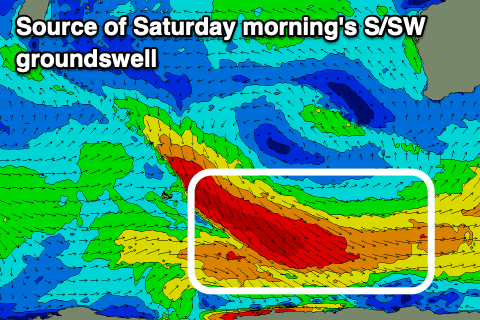
Our secondary pulse of SW groundswell for late in the day Friday and Saturday morning is still on track, with a slight upgrade on the expected size. It looks to come in from a slightly more southerly angle than tomorrow's swell, with the source being a great fetch of gale to severe-gale NW tending W/NW winds swinging in along the polar shelf, from the Indian Ocean.
Good sets to the 6ft to occasionally 8ft range are due in the South West again, 2ft in Mandurah and 1-2ft across Perth as winds slowly improve from Friday and swing S/SE in the South West, S/SE-SE further north. Stronger S/SE breezes are due into the afternoon in the South West, S/SW to the north.
Sunday still looks clean with a moderate E/SE offshore wind and easing surf from the 4ft+ range, tiny in Perth and Mandurah.
 Monday looks dicey with another trough due to bring S/SW winds, improving again Tuesday as it clears, swinging winds back to the E.
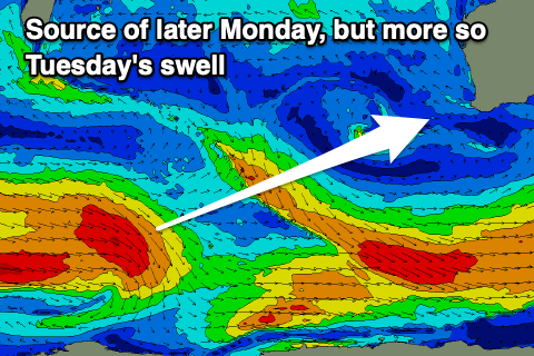
Swell wise, a new moderate sized mid-period SW swell is expected to build Monday afternoon and peak Tuesday, generated by a polar fetch of strong to gale-force W'ly winds moving in from the west of the Heard Island region today and tomorrow.
The front will weaken while pushing further east, with the swell due to come in at a fun 5-6ft in the South West, 2ft across Mandurah and 1-2ft in Perth.
Wednesday looks dicey again as winds swing back onshore due to another trough moving in, and this might continue to influence us through Thursday. Some new moderate-large sized SW swell may be seen later week, but we'll review this Friday.
Comments
Windy, but a good size with the new swell..