Improving conditions and fun surf over the coming days

Western Australia Surf Forecast by Craig Brokensha (issued Monday October 31st)
Best Days: Tomorrow morning, Margs Wednesday morning, Thursday, Saturday morning all locations, Monday morning in Margs
Features of the Forecast (tl;dr)
- Mod-large SW swell today, easing tomorrow and Wed
- S/SE winds in the South West tomorrow AM, SE further north ahead of sea breezes
- E/SE tending S/SW winds on Wed
- Mod-large SW groundswell arriving later Wed, peaking Thu AM, then easing
- Fresh E/NE tending lighter NE and then NW winds on Thu
- SW winds Fri, with a reinforcing SW groundswell for the PM
- Easing SW groundswell Sat with E/SE tending S/SW winds
- Smaller Sun with gusty S/SE winds
- Easing surf Mon with E/SE tending S/SW winds
Recap
The large, pumping surf seen into the end of last week eased through the weekend and Saturday was cleanest and best before S'ly winds got into a new pulse of SW energy yesterday.
Today a new moderate-large SW swell has filled in but S'ly winds are only favouring protected spots.
This week and weekend (Nov 1 - 6)
Today's good pulse of new swell will peak this afternoon and ease back through the coming days as a high edges in from the west, swinging winds slowly more offshore.
Tomorrow morning will see S/SE winds across the South West, SE further north and with easing, fun sets from the 5-6ft range across the South West, 2ft in Mandurah and a less consistent 2ft in Perth
Wednesday looks smaller again but with more favourable E/SE winds across all locations before sea breezes kick in.
L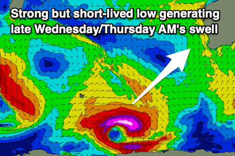 ater in the day Wednesday but more so Thursday morning a new pulse of SW groundswell is expected, generated by a strong but short-lived polar low firing up around the Heard Island region yesterday.
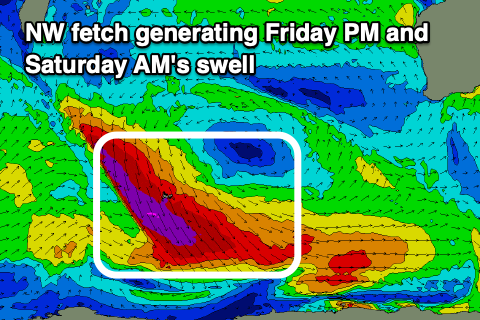
A fetch of severe-gale to storm-force W'ly winds were generated and behind this we'll see an additional fetch of NW gales tracking south-east, generating a secondary pulse of SW groundswell for Friday afternoon.
The first swell should peak around 6-8ft in the South West with 2ft+ waves in Mandurah and 2ft sets across Perth, with it arriving late Wednesday but peaking Thursday morning.
The swell will ease during the day and conditions look good with a gusty E/NE tending weaker NE breeze, light NW into the afternoon.
 Friday will unfortunately see a trough move through, bringing SW winds to all locations, though it should clear quickly into the weekend, allowing winds to swing back to the SE-E/SE in the morning Saturday.
The secondary SW groundswell for Friday afternoon looks a little smaller than the first, coming in around 6ft in the South West, easing Saturday from a similar size, 2ft in Mandurah and 1-2ft across Perth.
As the swell continues to ease Sunday, conditions look less favourable in the morning with a S/SE breeze, with offshore winds due to kick back in Monday ahead of a trough and S/SW winds from Tuesday. Fun pulses of mid-period SW swell are due into next week, but we'll review this Wednesday.