Small couple of days, fun on the weekend

Western Australia Surf Forecast by Craig Brokensha (issued Monday October 17th)
Best Days: South West magnets tomorrow and Wednesday mornings, Saturday morning all locations, early Sunday in the South West and Margs
Features of the Forecast (tl;dr)
- Easing SW swell Tue with E/SE winds ahead of sea breezes
- Small background SW swell Wed with E/SE winds ahead of sea breezes
- Small Thu with W/SW winds
- W/SW winds Fri with a moderate sized, late building SW swell, peaking Sat AM
- E tending W winds Sat, fresh E/NE tending N/NW then NW Sun with easing surf
Recap
Clean but easing surf from 3-4ft on Saturday morning across the South West, best on the magnets, while yesterday was a similar size but lumpy and bumpy with less favourable winds. Further north the swell came in a little better than expected across Mandurah Saturday with clean 2ft sets, 1ft in Perth. Yesterday was average with small to tiny surf and deteriorating winds.
Today conditions are average and onshore across the South West with a small increase in mid-period swell energy, 2ft+ in Mandurah and 1-2ft across Perth.
This week and weekend (Oct 18 - 23)
This afternoon's peak in mid-period swell should reach 4-5ft+ across the South West with a drop in size tomorrow across all locations as winds swing offshore.
A light E/SE breeze should clean up easing 4ft sets in the South West, 2ft Mandurah and 1-2ft Perth. Sea breezes will kick in early afternoon so surf before then.
Wednesday morning will be clean again along with a small mix of building mid-period SW swells thanks to a weak fetch of pre-frontal W/NW winds moving through our swell window yesterday. A longer period signal showing was generated in our far swell window and won't offer any real size, with the models over-forecasting the size.
Expect continuing sets in the 4ft range Wednesday morning in the South West and 1-1.5ft waves across Mandurah and Perth, similar Thursday morning.
 Unfortunately winds will shift W/SW into Thursday as a weak front pushes up and into us, persisting Friday but with a little less strength.
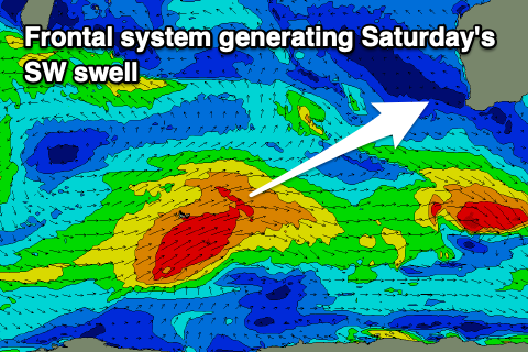
The front linked to these onshore winds will be attached to a weakening polar low pushing in from the east over the coming days, generating a fetch of strong to sub-gale-force W/SW winds in our south-western swell window.
This should produce a moderate sized, mid-period SW swell for later Friday, peaking Saturday morning as winds swing back offshore from the E across all locations.
This looks to be the pick of the weekend and period with clean 6ft+ surf in the South West, 2-3ft in Mandurah and 2ft across Perth. Sunday looks clean early but winds will quickly shift to the north so get in before then.
We'll be looking at smaller, easing 4-5ft waves in the South West, 1-2ft across Perth and Mandurah. Longer term weak but persistent frontal activity looks to continue along with deteriorating conditions into next week but we'll have a closer look at this Wednesday.