Developing onshore winds tomorrow, improving late week

Western Australia Surf Forecast by Craig Brokensha (issued Monday October 3rd)
Best Days: Today in the South West, early tomorrow in the South West, Thursday morning Perth and Mandurah, Friday all locations, early Saturday Margs
Features of the Forecast (tl;dr)
- Easing surf tomorrow with strong E/NE tending NE winds, then N/NW-NW into the arvo while easing a touch
- Building W/SW-SW low-period swell Wed with strong SW tending S/SW winds (W/NW early Perth/Mandurah)
- Stronger W/SW and SW swells Thu, peaking into the PM with fresh S/SW winds (S/SE in AM Perth/Mandurah)
- Easing SW swell Fri with E winds ahead of sea breezes
- Easing surf Sat with variable NE tending stronger NW winds
- Moderate sized SW swell Mon with strong SW tending S/SW winds
Recap
A little wind affected on Saturday with a peak in new SW groundswell with clean conditions and fun 4-5ft sets in the South West. Sunday offered similar sized waves with cleaner conditions.
Mandurah was tiny on Saturday with sets to 1ft, similar in Perth while yesterday surprisingly provided better 1-2ft sets when the swell should have been on the ease.
Today we've got a good pulse of new W/SW swell and clean conditions with 4-6ft sets in the South West and 2ft sets continuing across Perth and Mandurah. Conditions are due to remain favourable across the South West into this afternoon, while to the north, gusty sea breezes will kick in.

Good sets this AM
This week and weekend (Oct 4 - 9)
Looking at the coming week and early next, we've got a run of onshore winds and poor conditions due across the South West along with two large pulses of mid-period swell energy.
Conditions will be clean tomorrow morning with a strong E/NE tending NE breeze, easing a touch and tending more N/NW-NW into the afternoon and evening. We'll see today's swell easing back from 4ft across the South West, tiny in Perth and Mandurah with 1-1.5ft sets.
 The swing in winds to the NW will be associated with a trough moving in from the west, and now we're not expected to see this trough form into that strong a low. Instead we'll see weak W/SW-SW winds projected into us impacting us on Wednesday, bringing a strong SW tending S/SW change.
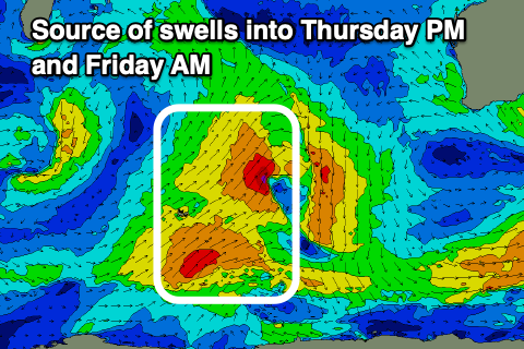
There'll be a mix of localised swell on the build Wednesday with more distant, mid-period W/SW-SW energy from the earlier stages of the trough in the Indian Ocean yesterday and a polar front today due to fill in Thursday.
Looking at Wednesday though and building sets to a weak 6ft are due across the South West later in the day, 2ft to the north with Thursday seeing building sets to 8ft in the South West, 2-3ft in Mandurah and 2ft+ across Perth.
Unfortunately strong SW winds will persist across the South West, S/SE early in Perth and Mandurah while we might see light E winds on Friday morning across Margs as the swell starts to ease from a similar size to Thursday afternoon (6-8ft South West).
 This window of light winds and a NE breeze on Saturday morning will be brief, with strengthening onshore winds due to kick back in again from Saturday afternoon as the next mid-latitude storm approaches.
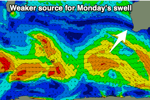
This storm will have polar origins but offer no real strength, with surf to 6ft+ due across the South West and 2ft+ waves further north in Mandurah, 2ft across Perth on Monday afternoon but with strong SW tending S/SW winds. Perth and Mandurah should see a window of early S/SE winds but with a little less size early in the morning.
Depending on the movement of the low, we'll either see conditions improve slowly through the middle of next week, or a lag, with onshore winds and average surf until later in the week. More on this in the coming updates.
Comments
wednesday update?
Here it is: https://www.swellnet.com/reports/forecaster-notes/western-australia/2022...
Go into your profile and click the tick box to get notifications of the West Oz Forecaster Notes and that should help in not missing any updates.