Improving surf into the end of the week

Western Australia Surf Forecast by Craig Brokensha (issued Wednesday October 5th)
Best Days: Perth and Mandurah tomorrow morning, Friday morning all locations, early Saturday Margs and Mandurah, Tuesday morning Perth and Mandurah
Features of the Forecast (tl;dr)
- Stronger W/SW and SW swells Thu, peaking into the mid-late PM with fresh SW tending S/SW winds (offshore Perth/Mandurah in the AM)
- Easing SW swell Fri with E-E/SE winds ahead of sea breezes
- Easing surf Sat with light, early E/NE tending fresher NW winds into the PM around Margs, SW further north
- Smaller Sun with fresh W/SW-SW winds (possibly variable early Perth and Mandurah)
- Moderate-large sized mid-period SW swell Mon with strong SW winds
- Easing surf Tue with lingering SW winds in Margs, cleaner Perth and Mandurah
Recap
Early clean conditions yesterday but a small, leftover swell with deteriorating conditions into the late morning and early afternoon.
Today a trough has brought a strong onshore change with some weak, building windswell. The Margs cams are back and running as well, shown below.

Literal dog's breakfast today
This week and next (Oct 6 - 9)
Today's localised, strong SW winds are attached to a weak frontal system, with a secondary front due to move in this evening and tomorrow, maintaining poor, gusty SW tending S/SW winds across the South West. Perth and Mandurah will be nice and clean with a light SE offshore in the latter and E across the former.
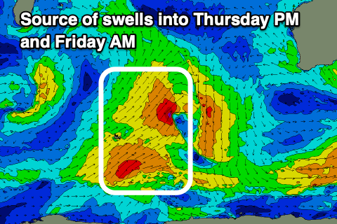 Swell wise, stronger pulses of mid-period W/SW and SW swell are due to fill in and peak tomorrow afternoon. Sets to 8ft are due in the South West through the afternoon but with those poor winds, 2-3ft in Mandurah and 2ft+ across Perth though smaller and peakier in the morning (mostly 2ft) when cleaner.
Friday still looks great across all locations with a high due to move in behind tomorrow's front, swinging winds E/SE in the morning ahead of W/SW sea breezes.
There should be plenty of size left in the mix with easing 6-8ft waves in the South West, 2-3ft across Mandurah and 2ft+ in Perth, smaller Sunday and with early E/NE winds ahead of the next front and strengthening afternoon NW winds in the South West. Perth and Mandurah will see SW sea breezes.
Sunday looks to be a lay day as the next approaching frontal system brings fresh W/SW-SW winds along with a further drop in size from Saturday. Perth and Mandurah may see a window of early variable winds though with no real size.
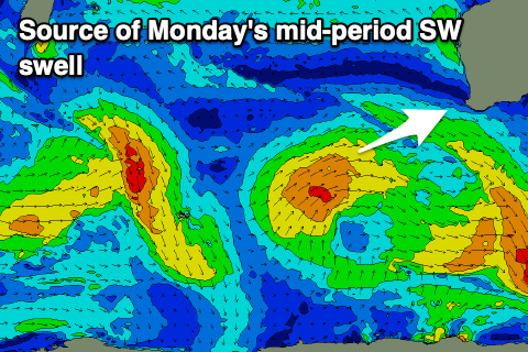 This front will actually be attached to a weak low, with a slow moving fetch of strong W/SW winds expected to generate a moderate-large, mid-period SW swell for Monday, peaking into the afternoon. 6ft+ waves are due in the South West, 2ft+ in Mandurah and 2ft across Perth but with strong SW winds.
Tuesday will become cleaner in Perth and Mandurah as the swell eases, with onshore SW winds lingering across the South West.
Longer term it doesn't look to be until later in the week that winds go offshore again for the South West with a couple of moderate sized + swells. More on this Friday.